Gazetteer of New Zealand Names - 3 November 2011
Gazetteer of New Zealand Names - 3 November 2011
Gazetteer of New Zealand Names - 3 November 2011
Create successful ePaper yourself
Turn your PDF publications into a flip-book with our unique Google optimized e-Paper software.
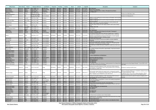
Official Name Name Status Feature Statutory Reference Land District Projection Northing Easting Datum Latitude Longitude Description Comment<br />
Maharakeke Approved Settlement 1941 (HON) p.15 Hawke's Bay NZTM2000 5564100 1893800 NZGD2000 40 01 20 S 176 26 34 E Not "Marakeke"<br />
Mahenotapuku Approved Island 1940 (HON) p.15 North Auckland NZTM2000 6108000 1718900 NZGD2000 35 09 50 S 174 18 20 E North-west <strong>of</strong> Cape Brett<br />
Mahers Stream Approved Stream 1969 (8) p.240 Wellington NZTM2000 5445100 1779100 NZGD2000 41 07 32 S 175 08 01 E Tributary <strong>of</strong> Mangaroa River. In Block II, Rimutaka Survey District<br />
Mahiaruhe Stream Approved Stream 1940 (HON) p.15 Hawke's Bay NZTM2000 5652400 1934500 NZGD2000 39 12 48 S 176 52 26 E For "Mahiaruha"<br />
Mahināpua<br />
Creek/Tūwharewhare<br />
Approved Creek<br />
Ngāi Tahu Claims<br />
Settlement Act 1998<br />
Westland NZTM2000 5267700 1432400 NZGD2000 42 43 30 S 170 57 10 E Alteration from Mahināpua Creek<br />
Mahipatua Pa Approved Pa<br />
Te Uri o Hau Claims<br />
Settlement Act 2002<br />
North Auckland NZTM2000 5981700 1698700 NZGD2000 36 18 17 S 174 05 58 E Alteration from Mahipatua Pa<br />
Mahitahi Approved Locality 1950 (70) p.1989 Westland NZTM2000 5166700 1324100 NZGD2000 43 36 06 S 169 34 54 E<br />
Maitahi is correct spelling but to avoid confusion with Maitahi, North Auckland,<br />
this form is retained<br />
Mahitahi Post Office Approved Post Office 1950 (70) p.1989 Westland NZTM2000 5161600 1325800 NZGD2000 43 38 53 S 169 36 00 E<br />
Maitahi is correct spelling but to avoid confusion with Maitahi, North Auckland,<br />
this form is retained<br />
Mahitahi River Approved River 1950 (70) p.1989 Westland NZTM2000 5161600 1325700 NZGD2000 43 38 53 S 169 35 56 E<br />
Maitahi (1930 Hon p. 15) is correct spelling but to avoid confusion with<br />
Maitahi, North Auckland, this form is retained<br />
Mahoe Stream Approved Stream 1969 (8) p.240 Southland NZTM2000 4974700 1121650 NZGD2000 45 13 06 S 166 54 27 E<br />
Secretary Island; Flows from main ridge to western coast, south <strong>of</strong> Rocky<br />
Point<br />
Mahora Approved Trig Station 1944 (HON) p.15 North Auckland NZTM2000 6019900 1669300 NZGD2000 35 57 46 S 173 46 07 E Geodetic code: 1361<br />
Mahura Railway Station Approved<br />
Railway<br />
Station<br />
1928 (HON) p.15 North Auckland NZTM2000 6019900 1669300 NZGD2000 35 57 46 S 173 46 07 E Near Huntly<br />
Maikukutea Approved Block 1941 (HON) p.15 Gisborne NZTM2000 5785500 2045800 NZGD2000 37 58 07 S 178 04 26 E Not "Meakokutea"<br />
Maimai Creek Approved Stream 1971 (13) p.259 Westland NZTM2000 5169400 1339900 NZGD2000 43 34 59 S 169 46 42 E Tributary <strong>of</strong> Karangarua River flowing from the peak, "Karangarua"<br />
Maioha Stream Approved Stream 1989 (120) p.3005 North Auckland NZTM2000 5917400 1734600 NZGD2000 36 52 47 S 174 30 37 E Tributary <strong>of</strong> Waitakere River<br />
The ironsands mining area at the north head, Waikato River. Traditional<br />
Maioro Approved Area 2006 (63) p.1513 North Auckland NZTM2000 5864200 1752600 NZGD2000 37 21 23 S 174 43 23 E<br />
ancestral name applying to an area covering Waiuku Forest, and formerly<br />
referred to as the ironsands mining area. Not named on current mapping<br />
(Replacing 26/02/1970 10:297). Not Maioro Sands<br />
Mairangi Bay Approved Bay 1932 (HON) p.15 North Auckland NZTM2000 5932700 1757200 NZGD2000 36 44 18 S 174 45 38 E Formerly part <strong>of</strong> Murray Bay<br />
Mairangi Bay Approved Suburb 2007 (138) p.3623 North Auckland NZTM2000 5932400 1756100 NZGD2000 36 44 29 S 174 44 54 E<br />
North Shore City Suburb centred around NZMG coordinate 2666600E<br />
6494200N<br />
Maire Bay Approved Bay 1970 (10) p.297 North Auckland NZTM2000 5932900 1756700 NZGD2000 36 44 12 S 174 45 18 E Larger bay on south coast, north-east <strong>of</strong> Coppermine Point<br />
Maitai Bay Approved Bay 1994 (133) p.4349 North Auckland NZTM2000 6146400 1637500 NZGD2000 34 49 26 S 173 24 36 E<br />
Bay between Maitai Point and Omahuri. Change from Ohungahunga Bay<br />
(1943 Hon p. 22). Matai Bay GR 490083 deleted<br />
Maitai Point Approved Point 1995 (69) p.1847 North Auckland NZTM2000 6146000 1637800 NZGD2000 34 49 39 S 173 24 48 E<br />
Point NE side <strong>of</strong> Karikari Peninsula. Change from Jolliffe Point (1943 Hon p.<br />
12)<br />
Major Jones Pool Approved River Feature 1987 (163) p.4458 Wellington NZTM2000 5679880 1843610 NZGD2000 38 59 46 S 175 48 47 E<br />
Majorie Falls Approved Waterfall 1967 (4) p.120 Southland NZTM2000 4988900 1147300 NZGD2000 45 06 29 S 167 14 43 E<br />
In a northern tributary <strong>of</strong> Irene River, approximately 1 mile from the head <strong>of</strong><br />
Emelius Arm<br />
Makahakaha Stream Approved Stream 1941 (HON) p.15 Gisborne NZTM2000 5729500 2047200 NZGD2000 38 28 14 S 178 07 30 E Not Makahaka<br />
Makahakaha Stream Approved Stream 1941 (HON) p.15 Wellington NZTM2000 5448200 1821600 NZGD2000 41 05 14 S 175 38 18 E Not Makahaka<br />
Makahi Approved Block 1941 (HON) p.15 Gisborne NZTM2000 5771200 2065300 NZGD2000 38 05 14 S 178 18 15 E Not "Mohaki"<br />
Makahikatoa Stream Approved Stream 1941 (HON) p.15 Gisborne NZTM2000 5823400 2052700 NZGD2000 37 37 30 S 178 07 42 E<br />
Makahikatoa Stream Approved Stream 1941 (HON) p.15 Gisborne NZTM2000 5823200 2053000 NZGD2000 37 37 36 S 178 07 55 E In place <strong>of</strong> Makakikotoa and Matahikatoa<br />
Makahikatoa Stream Approved Stream 1941 (HON) p.15 Gisborne NZTM2000 5823300 2052300 NZGD2000 37 37 34 S 178 07 26 E<br />
Makaka Bay Approved Bay 1988 (206) p.5173 North Auckland NZTM2000 5900200 1735600 NZGD2000 37 02 05 S 174 31 29 E North side <strong>of</strong> Manukau Entrance<br />
Makaka Creek Approved Stream 1969 (8) p.240 Wellington NZTM2000 5463000 1799600 NZGD2000 40 57 35 S 175 22 18 E Block II, Waiohine Survey District<br />
Makakapango Stream Approved Stream 1941 (HON) p.15 Gisborne NZTM2000 5791700 2050400 NZGD2000 37 54 39 S 178 07 20 E Not "Makakapanga"<br />
Makarewa River Approved River 1930 (HON) p.15 Southland NZTM2000 4862600 1247900 NZGD2000 46 17 55 S 168 25 41 E Not "Makerewa"<br />
Makarewa Township Approved Town 1930 (HON) p.15 Southland NZTM2000 4858600 1242100 NZGD2000 46 19 53 S 168 20 59 E Not "Makerewa"<br />
Mākaro / Ward Island Approved Island 2009 (161) p.3887 Wellington NZTM2000 5426900 1756700 NZGD2000 41 17 39 S 174 52 17 E<br />
Makarora Approved Locality 2010 (173) p.4271 Otago NZTM2000 5095400 1299100 NZGD2000 44 13 57 S 169 13 56 E<br />
Makarora Gorge Approved Gorge 1966 (1) p.18 Otago NZTM2000 5107200 1307800 NZGD2000 44 07 48 S 169 20 51 E<br />
In Wellington Harbour (Port Nicholson). Spelling alteration from Makaro/Ward<br />
Island (macron and spaces to be added).<br />
Settlement along State Highway 6, 9.5km north <strong>of</strong> the northern shores <strong>of</strong><br />
Lake Wanaka, at the gateway to Mount Aspiring National Park. NZTopo50<br />
BZ12-Makarora, GR 991 954.<br />
Replacing previous <strong>New</strong> <strong>Zealand</strong> Gazette, 12 June 1997, No. 60,<br />
page 1403.<br />
Assigning an existing recorded name.<br />
Makaroa corrected to Makarora on 11/03/2010. Entered in error into<br />
Narrow gorge, steeply sided with irregular terrain, running east to west for<br />
the original spreadsheet in 2008.<br />
approximately 1km, and following the Makarora River. NZTopo50 BZ13-Haast<br />
Corrigendum 2010 (115) p.3108 to replace description: "Block V,<br />
Pass / Tioripatea, start: GR 086 073 to end: GR 073 075.<br />
Haast Survey District. Near the source <strong>of</strong> the Makarora River."<br />
Makarora Township Approved Locality 2010 (173) p.4271 Otago NZTM2000 5087600 1296600 NZGD2000 44 18 05 S 169 11 47 E<br />
Settlement along State Highway 6, 1.6km north <strong>of</strong> the northern shores <strong>of</strong><br />
Lake Wanaka. NZTopo50 BZ12-Makarora, GR 966 876.<br />
Makatote Stream Approved Stream 1941 (HON) p.15 Gisborne NZTM2000 5788700 2062100 NZGD2000 37 55 55 S 178 15 24 E Not "Makatatota"<br />
Maketu Stream Approved Stream 1960 (7) p.139 North Auckland NZTM2000 5887800 1777000 NZGD2000 37 08 22 S 174 59 34 E<br />
Flows south-westerly through Block V; thence north-westerly through Block<br />
VIII into Hingaia Stream<br />
Makiekie Creek Approved Stream 1941 (HON) p.15 Hawke's Bay NZTM2000 5662000 1898000 NZGD2000 39 08 25 S 176 26 52 E Not "Makiakia"<br />
Makirikiri Stream Approved Stream 1987 (62) p.1964 Nelson NZTM2000 5354700 1474300 NZGD2000 41 56 59 S 171 29 00 E Stream flowing through Hole in the Hill, into the Nile River<br />
Makirikiri Tarns Approved Pond 1995 (69) p.1847 Wellington NZTM2000 5610100 1871000 NZGD2000 39 36 58 S 176 09 25 E<br />
A wetland area near the headwaters <strong>of</strong> the Waiokotore Stream, north west<br />
Ruahine Range<br />
Makokomuka Stream Approved Stream 1941 (HON) p.15 Gisborne NZTM2000 5763000 2061800 NZGD2000 38 09 45 S 178 16 11 E In place <strong>of</strong> Makokomuku and Mokokomuka<br />
Makokomuka Stream Approved Stream 1941 (HON) p.15 Gisborne NZTM2000 5763300 2062700 NZGD2000 38 09 34 S 178 16 47 E Not "Makokomuku"<br />
Makorori Point Approved Point 1941 (HON) p.16 Gisborne NZTM2000 5707900 2044200 NZGD2000 38 39 58 S 178 06 16 E Not "Makarori"<br />
Makoura Stream Approved Stream 1950 (70) p.1989 Wellington NZTM2000 5491800 1863400 NZGD2000 40 40 57 S 176 07 00 E<br />
Makumete Stream Approved Stream 1941 (HON) p.16 Gisborne NZTM2000 5776500 2061500 NZGD2000 38 02 30 S 178 15 27 E Not "Makomete"<br />
Makuriwao Stream Approved Stream 1941 (HON) p.16 Gisborne NZTM2000 5747800 2018100 NZGD2000 38 19 14 S 177 46 54 E Not "Makarue"<br />
Malam Gully Approved Valley 1989 (120) p.3005 North Auckland NZTM2000 5912200 1743500 NZGD2000 36 55 31 S 174 36 40 E<br />
Malaspina Approved Mountain 1953 (67) p.1920<br />
Canterbury &<br />
Westland<br />
NZTM2000 5171000 1369500 NZGD2000 43 34 42 S 170 08 43 E On Main Divide immediately south <strong>of</strong> Clarke Saddle<br />
Malaspina Reach Approved Bay 1964 (79) p.2365 Southland NZTM2000 4962400 1130800 NZGD2000 45 20 05 S 167 00 42 E<br />
Doubtful Sound. To be applied to that portion <strong>of</strong> the Sound from Flurry Head<br />
(Bauza Island) to Kellard Point<br />
Malaspina Sound Approved Bay 1939 (HON) p.16 Southland NZTM2000 4961400 1130400 NZGD2000 45 20 36 S 167 00 21 E Formerly Smith Sound<br />
Malcher Peak Approved Peak 1978 (13) p.422 Canterbury NZTM2000 5167700 1378100 NZGD2000 43 36 38 S 170 15 01 E A peak between Novara Park and Mt. Johnson on the Malte Brun Range<br />
Malcolm Col Approved Col 1943 (HON) p.16 Westland NZTM2000 5203200 1421900 NZGD2000 43 18 11 S 170 48 15 E Head <strong>of</strong> Frances Glacier<br />
<strong>New</strong> <strong>Zealand</strong> <strong>Names</strong><br />
Assigning a new name for a place not named on mapping, but in<br />
local use.<br />
<strong>New</strong> <strong>Zealand</strong> <strong>Gazetteer</strong> <strong>of</strong> Official Geographic <strong>Names</strong> (8 <strong>November</strong> <strong>2011</strong>)<br />
<strong>New</strong> <strong>Zealand</strong> Geographic Board Ngā Pou Taunaha o Aotearoa Page 50 <strong>of</strong> 120


