

Gazetteer of New Zealand Names - 3 November 2011
Gazetteer of New Zealand Names - 3 November 2011
Gazetteer of New Zealand Names - 3 November 2011

You also want an ePaper? Increase the reach of your titles
YUMPU automatically turns print PDFs into web optimized ePapers that Google loves.
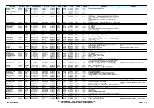
Official Name Name Status Feature Statutory Reference Land District Projection Northing Easting Datum Latitude Longitude Description Comment<br />
Mangapakeha Taipo Approved Rock Feature 1981 (58) p.1326 Wellington NZTM2000 5466200 1853500 NZGD2000 40 54 58 S 176 00 37 E Rocky pinnacle outcrop to east <strong>of</strong> Tinui<br />
Mangapehi Approved Block 1941 (HON) p.17 Taranaki NZTM2000 5735100 1800000 NZGD2000 38 30 36 S 175 17 38 E<br />
Mangapehi Railway Station Approved<br />
Railway<br />
Station<br />
1941 (HON) p.17 Taranaki NZTM2000 5735300 1800400 NZGD2000 38 30 29 S 175 17 54 E<br />
Mangapehi Stream Approved Stream 1941 (HON) p.17 Taranaki NZTM2000 5733700 1802000 NZGD2000 38 31 20 S 175 19 02 E<br />
Mangapiko Hill Approved Hill 1943 (HON) p.17 North Auckland NZTM2000 6119600 1669900 NZGD2000 35 03 50 S 173 45 60 E<br />
Mangapokia (1941 Hon p. 17) is the correct spelling but Mangapokio is<br />
Mangapokio Stream Approved Stream 1958 (73) p.1731 Wellington NZTM2000 5454100 1859100 NZGD2000 41 01 23 S 176 04 54 E<br />
adopted by virtue <strong>of</strong> long usage and also to avoid confusion with Mangapokia<br />
Stream, another tributary <strong>of</strong> the Whareama River in Block II, Rewa Survey<br />
District<br />
Mangapouri Stream Approved Stream 1976 (110) p.2453 South Auckland NZTM2000 5808300 1848800 NZGD2000 37 50 20 S 175 49 38 E<br />
A tributary <strong>of</strong> Waihou River. Instead <strong>of</strong> "Te Raha Stream" (26/11/1953<br />
67:1920)<br />
Mangapukatea Stream Approved Stream 1976 (110) p.2453 South Auckland NZTM2000 5824300 1848000 NZGD2000 37 41 42 S 175 48 46 E A tributary <strong>of</strong> Waihou River. Instead <strong>of</strong> "Brooke Stream" (26/11/1953 67:1920)<br />
Mangapunipuni Stream Approved Stream 1950 (4) p.39 Wellington NZTM2000 5599900 1757600 NZGD2000 39 44 10 S 174 50 21 E Instead <strong>of</strong> Mangapuni<br />
Mangarangiora Stream Approved Stream 1941 (HON) p.17 Gisborne NZTM2000 5819200 2059700 NZGD2000 37 39 33 S 178 12 36 E Not "Mangatangiora"<br />
Mangarata Stream Approved Stream 1941 (HON) p.17 Gisborne NZTM2000 5793500 2041500 NZGD2000 37 53 56 S 178 01 13 E Not "Mangatata"<br />
Mangareia Road Approved Road 1941 (HON) p.17 Wellington NZTM2000 5481800 1840100 NZGD2000 40 46 47 S 175 50 43 E Not "Mangarai"<br />
Mangarewa Stream Approved Stream 2007 (4) p.120 South Auckland NZTM2000 5837800 1822000 NZGD2000 37 34 48 S 175 30 51 E<br />
Stream flowing generally northerly into Piako River, north <strong>of</strong> Morrinsville. Not<br />
named on current mapping<br />
Mangaroa Approved Trig Station 1930 (HON) p.17 Wellington NZTM2000 5446180 1776370 NZGD2000 41 06 60 S 175 06 03 E Trig above Mangaroa Hill Road, geodetic code: 7504<br />
Mangaroa Pa Approved Pa 1943 (HON) p.17 North Auckland NZTM2000 6096300 1714700 NZGD2000 35 16 12 S 174 15 40 E<br />
Mangaroa Post Office Approved Post Office 1930 (HON) p.17 Wellington NZTM2000 5445720 1777450 NZGD2000 41 07 14 S 175 06 49 E<br />
Mangaroa Railway Station Approved<br />
Railway<br />
Station<br />
1930 (HON) p.17 Wellington NZTM2000 5445720 1777450 NZGD2000 41 07 14 S 175 06 49 E Railway station on old Wairarapa Railway Line alignment<br />
Mangaroa Stream Approved Stream 1954 (80) p.2088 North Auckland NZTM2000 6130600 1653600 NZGD2000 34 57 57 S 173 35 14 E<br />
Rises south <strong>of</strong> Puketutu Trig. Stations and flows generally south-westerly into<br />
Mangonui Harbour. Also <strong>of</strong>ficial by 1943 Hon p. 17. Instead <strong>of</strong> Maunoaroa<br />
Mangaroa Stream Approved Stream 1930 (HON) p.17 Wellington NZTM2000 5446450 1777200 NZGD2000 41 06 50 S 175 06 38 E Tributary <strong>of</strong> the Hutt River<br />
Mangaruaki Stream Approved Stream 1941 (HON) p.17 Gisborne NZTM2000 5730900 2032500 NZGD2000 38 27 55 S 177 57 22 E Not "Mangarueke"<br />
Mangatakauare Stream Approved Stream 1983 (18) p.409 Gisborne NZTM2000 5816700 <strong>2011</strong>900 NZGD2000 37 42 16 S 177 40 17 E Correct spelling for name <strong>of</strong> stream<br />
Mangatakoto Road Approved Road 1941 (HON) p.17 Wellington NZTM2000 5500200 1823000 NZGD2000 40 37 08 S 175 38 11 E Not "Mangatakato"<br />
Mangatara Stream Approved Stream 2008 (177) p.4620 North Auckland NZTM2000 6020180 1670270 NZGD2000 35 57 37 S 173 46 45 E<br />
Stream located west <strong>of</strong> Dargaville, and flowing eastward into Kaihu River,<br />
source P07 809821, confluence P07 871835<br />
Not named on map. Subject to Te Roroa Claims Settlement Act<br />
2008.<br />
Mangatarere Approved Trig Station 1969 (8) p.240 Wellington NZTM2000 5463800 1812200 NZGD2000 40 56 58 S 175 31 16 E Block II, Tiffin Survey District<br />
Mangatawa Approved Hill 1980 (66) p.1752 South Auckland NZTM2000 5822600 1885900 NZGD2000 37 41 57 S 176 14 34 E For the hill in the Tauranga district. Reinstates Maungatawa (28/10/1976 110:2453)<br />
Mangatawai Stream Approved Stream 1943 (HON) p.17 North Auckland NZTM2000 6081100 1679600 NZGD2000 35 24 37 S 173 52 36 E Flowing into Waiparera Stream<br />
Mangaterere Stream Approved Stream 1949 (22) p.858 Wellington NZTM2000 5456400 1810700 NZGD2000 41 00 59 S 175 30 21 E<br />
Mangatete Stream Approved Stream 1969 (8) p.240 Wellington NZTM2000 5433500 1794700 NZGD2000 41 13 35 S 175 19 23 E Block XI, Wairarapa Survey District<br />
Mangati Bay Approved Bay 1984 (1) p.24 North Auckland NZTM2000 5985400 1812400 NZGD2000 36 15 11 S 175 21 51 E Confirmation <strong>of</strong> correct position for name<br />
Mangatoetoe Stream Approved Stream 1941 (HON) p.17 Gisborne NZTM2000 5814500 2084600 NZGD2000 37 41 19 S 178 29 39 E Not "Mangatoitoi"<br />
Mangatoetoe Stream Approved Stream 1991 (53) p.1213 North Auckland NZTM2000 5920500 1737000 NZGD2000 36 51 05 S 174 32 12 E Name change from Dilworth Stream<br />
Mangatoetoenui Glacier Approved Glacier 1937 (HON) p.17 Wellington NZTM2000 5650100 1822800 NZGD2000 39 16 11 S 175 34 58 E On Mount Ruapehu. Formerly Waikato<br />
Mangatokerau River Approved River 1941 (HON) p.17 Gisborne NZTM2000 5749600 2058600 NZGD2000 38 17 04 S 178 14 31 E Not "Hikuwai"<br />
Mangatumaru Stream Approved Stream 1941 (HON) p.17 Gisborne NZTM2000 5708800 1999100 NZGD2000 38 40 46 S 177 35 14 E Not "Maungataumaru"<br />
Mangawai Stream Approved Stream 1953 (67) p.1920 South Auckland NZTM2000 5800300 1845300 NZGD2000 37 54 42 S 175 47 25 E Flows from Lots 8 and 8A, D.P. 7128, through Lot 9 into Waihou River<br />
Mangawawe Stream Approved Stream <strong>2011</strong> (168) p.4696 South Auckland NZTM2000 5791500 1786500 NZGD2000 38 00 18 S 175 07 27 E<br />
A small stream, 8km long, flowing easterly then north-easterly into Waipa<br />
River, located just west and north-west <strong>of</strong> Pirongia. NZTopo50 BE33-<br />
Pirongia, from source GR 865 915 to confluence GR 916 947 (NZTM:<br />
5794700N 1791600E; NZGD2000: 37 58 30.449 S 175 10 53.158 E)<br />
Spelling alteration from Mangawawa Stream (recorded name).<br />
Mangaweka Approved Trig Station 1950 (70) p.1989 Wellington NZTM2000 5587900 1864000 NZGD2000 39 49 04 S 176 05 04 E Instead <strong>of</strong> Kawhatau (1944 Hon p. 13)<br />
Mangawhai Approved Locality 1951 (55) p.1019 North Auckland NZTM2000 6001200 1741100 NZGD2000 36 07 25 S 174 34 05 E Formerly known as Mangawai. Also <strong>of</strong>ficial by 1930-1939 Hon p. 17.<br />
Mangawhai Approved Trig Station 1951 (55) p.1019 North Auckland NZTM2000 6001200 1741100 NZGD2000 36 07 25 S 174 34 05 E Formerly known as Mangawai. Also <strong>of</strong>ficial by 1930-1939 Hon p. 17.<br />
Mangawhai Harbour Approved Harbour 1951 (55) p.1019 North Auckland NZTM2000 6003800 1743200 NZGD2000 36 05 60 S 174 35 27 E Formerly known as Mangawai. Also <strong>of</strong>ficial by 1930-1939 Hon p. 17.<br />
Mangawhai Parish Approved Parish 1951 (55) p.1019 North Auckland NZTM2000 6001000 1741200 NZGD2000 36 07 32 S 174 34 09 E Formerly known as Mangawai. Also <strong>of</strong>ficial by 1930-1939 Hon p. 17.<br />
Mangawhai Post Office Approved Post Office 1951 (55) p.1019 North Auckland NZTM2000 6001000 1741200 NZGD2000 36 07 32 S 174 34 09 E Formerly known as Mangawai<br />
Mangawhai River Approved River 1951 (55) p.1019 North Auckland NZTM2000 6016500 1715800 NZGD2000 35 59 21 S 174 17 05 E Formerly known as Mangawai. Also <strong>of</strong>ficial by 1930-1939 Hon p. 17.<br />
Mangawhara Stream Approved Stream 1975 (62) p.1632 South Auckland NZTM2000 5777800 1811100 NZGD2000 38 07 23 S 175 24 30 E A tributary <strong>of</strong> Mangatutu Stream. Instead <strong>of</strong> "Mangawhaia Stream"<br />
Mangawhengu Stream Approved Stream 1975 (62) p.1632 South Auckland NZTM2000 5839700 1839800 NZGD2000 37 33 31 S 175 42 53 E<br />
A tributary <strong>of</strong> Waihou River. Instead <strong>of</strong> "Mangaawhenga" or Mangauhenga<br />
Stream"<br />
Mangawhero Approved Trig Station 1944 (HON) p.17 North Auckland NZTM2000 6073800 1648400 NZGD2000 35 28 41 S 173 32 01 E<br />
Mangawhitikau Stream Approved Stream 1973 (15) p.365 South Auckland NZTM2000 5739000 1746700 NZGD2000 38 29 07 S 174 40 55 E Southern tributary <strong>of</strong> the Waikawau River<br />
Mangemange Stream Approved Stream<br />
Ngati Ruanui Claims<br />
Settlement Act 2003<br />
Taranaki NZTM2000 5629900 1715000 NZGD2000 39 28 22 S 174 20 13 E Alteration from Mangimangi Stream<br />
Mangemangeroa Creek Approved Stream 1992 (78) p.1514 North Auckland NZTM2000 5913000 1773800 NZGD2000 36 54 47 S 174 57 04 E Creek S <strong>of</strong> Howick flowing into Tamaki Strait<br />
Mangere Inlet Approved Bay 1982 (76) p.2163 North Auckland NZTM2000 5910300 1761500 NZGD2000 36 56 22 S 174 48 49 E Name for inlet to east <strong>of</strong> the Mangere Bridge<br />
Corrigendum: 31/01/1985 18:404 (amending reference to correct<br />
position)<br />
Mangerton Ridge Approved Ridge 1972 (18) p.379 Nelson NZTM2000 5351800 1595900 NZGD2000 41 59 09 S 172 57 02 E<br />
Mountain Ridge to the west <strong>of</strong> Coldwater Creek (a tributary <strong>of</strong> Wairau River),<br />
leading to the Raglan Range<br />
Mangohane Plateau Approved Plateau 1995 (69) p.1847 Wellington NZTM2000 5613100 1869300 NZGD2000 39 35 22 S 176 08 09 E<br />
A tussock grassland plateau <strong>of</strong> approximately 30 sq km, between Ohutu<br />
Ridge and Otupae Range, north west Ruahine Range<br />
Mangonui Harbour Approved Harbour 1930 (HON) p.17 North Auckland NZTM2000 6128100 1650200 NZGD2000 34 59 18 S 173 33 00 E Not "Mongonui"<br />
Mangoparerua Approved Locality 1932 (HON) p.17 North Auckland NZTM2000 5925000 1772500 NZGD2000 36 48 18 S 174 56 01 E On Motuihe Island<br />
Mangorewa River Approved River 1949 (22) p.858 South Auckland NZTM2000 5791800 1875200 NZGD2000 37 58 47 S 176 07 60 E Paraiti formerly used as alternative name<br />
Mangos Creek Approved Stream 1958 (73) p.1731 Canterbury NZTM2000 5229300 1487800 NZGD2000 43 04 51 S 171 37 18 E Rises on Black Range and flows westerly into Harper River near Windy Creek<br />
Maniakaroa Post Office Approved Post Office 1949 (22) p.858 South Auckland NZTM2000 5731300 1820700 NZGD2000 38 32 22 S 175 31 56 E<br />
Maniatoto County Approved County 1928 (HON) p.17 Otago NZTM2000 4997600 1371000 NZGD2000 45 08 17 S 170 05 15 E Not "Maniototo" Position to be determined<br />
Maniopotos Pool Approved River Feature 1990 (191) p.4192 South Auckland NZTM2000 5688160 1851460 NZGD2000 38 55 10 S 175 54 02 E Fishing pool on Tauranga Taupo River<br />
Maniototo Approved Locality 1960 (61) p.1515 Otago NZTM2000 4999300 1366300 NZGD2000 45 07 16 S 170 01 43 E In Central Otago. Instead <strong>of</strong> Maniatoto Reinstates Maniototo instead <strong>of</strong> Maniatoto (22/12/1954 80:2088)<br />
<strong>New</strong> <strong>Zealand</strong> <strong>Names</strong><br />
<strong>New</strong> <strong>Zealand</strong> <strong>Gazetteer</strong> <strong>of</strong> Official Geographic <strong>Names</strong> (8 <strong>November</strong> <strong>2011</strong>)<br />
<strong>New</strong> <strong>Zealand</strong> Geographic Board Ngā Pou Taunaha o Aotearoa Page 52 <strong>of</strong> 120


