

Gazetteer of New Zealand Names - 3 November 2011
Gazetteer of New Zealand Names - 3 November 2011
Gazetteer of New Zealand Names - 3 November 2011

You also want an ePaper? Increase the reach of your titles
YUMPU automatically turns print PDFs into web optimized ePapers that Google loves.
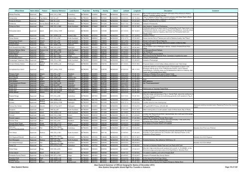
Official Name Name Status Feature Statutory Reference Land District Projection Northing Easting Datum Latitude Longitude Description Comment<br />
Pōhatu/Flea Bay Approved Bay 2003 (73) p.1896 Canterbury NZTM2000 5142000 1600900 NZGD2000 43 52 30 S 173 00 40 E<br />
Bay located approximately 5 km east north-east <strong>of</strong> the entrance to Akaroa<br />
Harbour. Currently named Flea Bay<br />
Pohatuhaha Approved Trig Station 1953 (3) p.87 Hawke's Bay NZTM2000 5605000 1879900 NZGD2000 39 39 32 S 176 15 45 E<br />
Trig. Q. Instead <strong>of</strong> Parks Peak, to avoid confusion with Parks Peak in Block<br />
III, Umutoi Survey District, Wellington Land District<br />
Pohaturiki Stream Approved Stream 1969 (8) p.240 Wellington NZTM2000 5442100 1809300 NZGD2000 41 08 44 S 175 29 39 E Block II, Huangarua Survey District<br />
Pohaturoa Approved Survey District 1950 (4) p.39 Westland NZTM2000 5299300 1512200 NZGD2000 42 27 13 S 171 55 56 E Instead <strong>of</strong> Pohaturoha<br />
Pohaturoa Rock Approved Rock 1950 (70) p.1989 South Auckland NZTM2000 5770400 1885100 NZGD2000 38 10 09 S 176 15 16 E Near Atiamuri. Instead <strong>of</strong> Powhateroa<br />
Confirmed name for an island west <strong>of</strong> Taukihepa/Big South Cape Island in the<br />
Pohowaitai Island Approved Island 2001 (149) p.3705 Southland NZTM2000 4754100 1170300 NZGD2000 47 13 33 S 167 19 24 E<br />
Titi/Muttonbird Islands, south-west <strong>of</strong> Stewart Island/Rakiura. Currently shown<br />
as Pohowaitai Island on mapping. Also known as Pohowaita Island and<br />
Wedge Island<br />
Pohue Approved Locality 1941 (HON) p.26 Hawke's Bay NZTM2000 5672700 1961900 NZGD2000 39 01 12 S 177 10 47 E Instead <strong>of</strong> "Pohui"<br />
Pohue Stream Approved Stream 1973 (15) p.365 South Auckland NZTM2000 5899500 1823600 NZGD2000 37 01 27 S 175 30 49 E Drains into the Firth <strong>of</strong> Thames just north <strong>of</strong> Waimou locality. Not "Puhoi"<br />
Pohutukawa Stream Approved Stream 2004 (33) p.751 North Auckland NZTM2000 5992900 1788900 NZGD2000 36 11 25 S 175 06 03 E Stream north-east <strong>of</strong> Mount Ngarahu<br />
Poikeke Island Approved Island 1973 (15) p.365 South Auckland NZTM2000 5921400 1849500 NZGD2000 36 49 13 S 175 47 50 E The islet just west <strong>of</strong> Motueka Island lying easterly <strong>of</strong> Mercury Bay<br />
Poinga Stream Approved Stream 1941 (HON) p.26 Gisborne NZTM2000 5698800 1971700 NZGD2000 38 46 52 S 177 16 43 E Not "Painga"<br />
Point Howard Post Office Approved Post Office 1962 (73) p.2021 Wellington NZTM2000 5431500 1760100 NZGD2000 41 15 07 S 174 54 39 E<br />
On the eastern side <strong>of</strong> Wellington Harbour. Instead <strong>of</strong> Howard Point Post<br />
Office<br />
Pokairoa Railway Siding Approved Railway Line 1954 (80) p.2088 South Auckland NZTM2000 5754300 1927600 NZGD2000 38 17 59 S 176 44 46 E On Murupara Branch Railway<br />
Pokohinu Point Approved Point 1941 (HON) p.26 Gisborne NZTM2000 5805400 2006700 NZGD2000 37 48 30 S 177 37 08 E Not "Pokahinu"<br />
Polhill Stream Approved Stream 1969 (8) p.240 Canterbury NZTM2000 5187800 1446600 NZGD2000 43 26 49 S 171 06 15 E Block III, Heron Survey District<br />
Polnoon Burn Approved Stream 1987 (62) p.1964 Otago NZTM2000 5038600 1261100 NZGD2000 44 43 33 S 168 43 14 E Burn flowing into the Shotover River. Correction <strong>of</strong> position for name<br />
Pomarangai Stream Approved Stream 1950 (70) p.1989 South Auckland NZTM2000 5752500 1762100 NZGD2000 38 21 40 S 174 51 19 E Instead <strong>of</strong> Pomarangei<br />
Pomarangai Telephone Office Approved<br />
Telephone<br />
Office<br />
1950 (70) p.1989 South Auckland NZTM2000 5752900 1757800 NZGD2000 38 21 29 S 174 48 22 E Instead <strong>of</strong> Pomarangei<br />
Pomare Railway Station Approved<br />
Railway<br />
Station<br />
1945 (HON) p.26 Wellington NZTM2000 5440600 1764700 NZGD2000 41 10 09 S 174 57 48 E Proposed station on Hutt Valley railway extension near Taita Gorge<br />
Confirmed name for a small island south <strong>of</strong> Rukawahakura Island in the<br />
Pomatakiarehua Island Approved Island 2001 (149) p.3705 Southland NZTM2000 4771500 1235700 NZGD2000 47 06 33 S 168 11 53 E<br />
Breaksea Islands group <strong>of</strong> the Titi/Muttonbird Islands, east <strong>of</strong> Stewart<br />
Island/Rakiura. Currently shown as Pomatakiarehua Island on mapping. Also<br />
known as Pohomatakiarehua Island<br />
Pompey Creek Approved Stream 1963 (76) p.1921 Westland NZTM2000 5222900 1418700 NZGD2000 43 07 30 S 170 46 16 E Tributary <strong>of</strong> Waitaha River east <strong>of</strong> Caesar Creek<br />
Ponganui Bay Approved Bay 1983 (18) p.409 Nelson NZTM2000 5468700 1667800 NZGD2000 40 55 48 S 173 48 19 E Correction <strong>of</strong> spelling from that as shown on NZMS1<br />
Ponui Stream Approved Stream 1945 (HON) p.26 Hawke's Bay NZTM2000 5659600 1956600 NZGD2000 39 08 23 S 177 07 32 E<br />
Pony Knob Approved Peak 1974 (11) p.233 Canterbury NZTM2000 5170800 1470500 NZGD2000 43 36 16 S 171 23 43 E Peak<br />
Pony Stream Approved Stream 1970 (10) p.297 Canterbury NZTM2000 5187400 1471300 NZGD2000 43 27 19 S 171 24 33 E Map reference<br />
Popaingawariwari Stream Approved Stream 1943 (HON) p.26 Gisborne NZTM2000 5772900 2059700 NZGD2000 38 04 29 S 178 14 22 E Not "Popaingawareware"<br />
Poplar Gully Approved Valley 1968 (9) p.268 Canterbury NZTM2000 5073000 1379700 NZGD2000 44 27 46 S 170 13 50 E<br />
Poplar Pool Approved River Feature 1987 (163) p.4458 Wellington NZTM2000 5684700 1841830 NZGD2000 38 57 12 S 175 47 27 E<br />
Poplar Pool Approved River Feature 1990 (191) p.4192 South Auckland NZTM2000 5688850 1851730 NZGD2000 38 54 47 S 175 54 12 E Fishing pool on Tauranga Taupo River<br />
Poplar Run Approved River Feature 1987 (163) p.4458 Wellington NZTM2000 5684860 1841570 NZGD2000 38 57 07 S 175 47 16 E<br />
Poplar Stream Approved Stream 1991 (32) p.687 Canterbury NZTM2000 5059600 1412800 NZGD2000 44 35 33 S 170 38 29 E Flows into Hakataramea River<br />
Mountain range commencing at Trig. L. Garnet Peak, above the confluence <strong>of</strong><br />
Poplars Range Approved Range 1973 (15) p.365 Canterbury NZTM2000 5291400 1556600 NZGD2000 42 31 43 S 172 28 18 E the Boyle and Lewis Rivers and extending generally north-easterly to Trig. Z,<br />
Mount St. Andrew<br />
Poraiti Approved Locality 1941 (HON) p.26 Hawke's Bay NZTM2000 5621700 1929800 NZGD2000 39 29 28 S 176 50 05 E Not "Poraite"<br />
Porewa Approved<br />
Railway<br />
Junction<br />
1984 (204) p.4798 Wellington NZTM2000 5567400 1812400 NZGD2000 40 01 01 S 175 29 20 E Locality name for new crossing loop<br />
Porirua City Centre Approved Suburb 2010 (173) p.4271 Wellington NZTM2000 5444800 1754500 NZGD2000 41 08 00 S 174 50 27 E NZTopo50 BP31-Porirua, GR 545 448.<br />
Altering an existing recorded name. Replacing Porirua City (recorded<br />
name).<br />
Poroporo Approved Beach 1953 (3) p.87 South Auckland NZTM2000 5789300 1947800 NZGD2000 37 58 38 S 176 57 34 E Māori landing place on south-western coast <strong>of</strong> White Island, Bay <strong>of</strong> Plenty<br />
Poroporo Island Approved Island 1940 (HON) p.26 North Auckland NZTM2000 6101000 1711000 NZGD2000 35 13 40 S 174 13 11 E<br />
Pororari Approved Locality 2003 (73) p.1896 Nelson NZTM2000 5339100 1463300 NZGD2000 42 05 18 S 171 20 50 E<br />
Locality near Perpendicular Point, approximately 3km north-east <strong>of</strong> Punakaiki.<br />
Currently named Porarari<br />
Pororari Lagoon Approved Lagoon 1992 (78) p.1513 Nelson NZTM2000 5337700 1462600 NZGD2000 42 06 03 S 171 20 18 E Lagoon NE Punakaiki at Pororari River mouth<br />
Pororari River Approved River 1972 (18) p.379 Westland NZTM2000 5337200 1462200 NZGD2000 42 06 19 S 171 20 00 E<br />
The river which enters the Tasman Sea approximately 1 mile north <strong>of</strong> the<br />
Punakaika River mouth. Instead <strong>of</strong> "Porarari"<br />
Pororari River Gorge Approved Gorge 1992 (78) p.1513 Nelson NZTM2000 5337100 1462700 NZGD2000 42 06 22 S 171 20 22 E River gorge on Pororari River E <strong>of</strong> Punakaiki<br />
Porotekoihamo Stream Approved Stream 1943 (HON) p.26 North Auckland NZTM2000 6095700 1669600 NZGD2000 35 16 46 S 173 45 55 E<br />
Port Levy<br />
(Potiriwi)/Koukourarata<br />
Approved Port<br />
Ngāi Tahu Claims<br />
Settlement Act 1998<br />
Canterbury NZTM2000 5170300 1587000 NZGD2000 43 37 13 S 172 50 20 E Alteration from Port Levy (Potiriwi)<br />
Port Ohope Approved Harbour 1963 (76) p.1921 South Auckland NZTM2000 5788100 1961100 NZGD2000 37 58 59 S 177 06 40 E<br />
Locality being the area comprising the peninsula extending from the western<br />
boundary <strong>of</strong> part subdivision B 2 <strong>of</strong> Section 246, Waimana Parish, to the<br />
entrance to Ohiwa Harbour<br />
Port Pegasus/Pikihatiti Approved Port<br />
Ngāi Tahu Claims<br />
Settlement Act 1998<br />
Southland NZTM2000 4757200 1198400 NZGD2000 47 12 57 S 167 41 44 E Alteration from Port Pegasus<br />
Port Whangarei Approved Harbour 1964 (15) p.464 North Auckland NZTM2000 6042400 1721900 NZGD2000 35 45 18 S 174 20 54 E Formerly Kioreroa. Also <strong>of</strong>ficial by 1938 Hon p. 42<br />
Port William/Potirepo Approved Port<br />
Ngāi Tahu Claims<br />
Settlement Act 1998<br />
Southland NZTM2000 4800300 1226300 NZGD2000 46 50 45 S 168 05 54 E Alteration from Port William<br />
Porter Col Approved Col 1974 (100) p.2163 Canterbury NZTM2000 5167700 1369300 NZGD2000 43 36 29 S 170 08 29 E The high col between Middle Peak and Low Peak at Mt Cook<br />
Porter Ridge Approved Ridge 1972 (18) p.379 Nelson NZTM2000 5393200 1603500 NZGD2000 41 36 46 S 173 02 31 E<br />
Mountain ridge extending south westerly from a point, S. 27/406886, on the<br />
Richmond range and lying to west <strong>of</strong> the Right Branch, Motueka River<br />
Porters Beach Approved Beach 1969 (8) p.240 Nelson NZTM2000 5464200 1524400 NZGD2000 40 58 12 S 172 06 05 E On western coastline, just north <strong>of</strong> Heaphy Bluff<br />
Portobello Survey District Approved Survey District 1953 (67) p.1920 Otago NZTM2000 4921900 1419300 NZGD2000 45 49 58 S 170 40 24 E Instead <strong>of</strong> Portobello Bay Survey District<br />
Poseidon Peak Approved Peak 1938 (HON) p.26 Otago NZTM2000 5052800 1221600 NZGD2000 44 34 43 S 168 14 02 E At the head <strong>of</strong> the Park Pass Glacier<br />
Possibility Col Approved Col 1938 (HON) p.26 Otago NZTM2000 5063500 1228900 NZGD2000 44 29 11 S 168 19 59 E Between Betty Peak and Mount Gates<br />
Possum Stream Approved Stream 1982 (76) p.2163 Marlborough NZTM2000 5380100 1604500 NZGD2000 41 43 51 S 173 03 15 E Name for stream flowing from Ragland Range to Wairau River<br />
<strong>New</strong> <strong>Zealand</strong> <strong>Names</strong><br />
<strong>New</strong> <strong>Zealand</strong> <strong>Gazetteer</strong> <strong>of</strong> Official Geographic <strong>Names</strong> (8 <strong>November</strong> <strong>2011</strong>)<br />
<strong>New</strong> <strong>Zealand</strong> Geographic Board Ngā Pou Taunaha o Aotearoa Page 78 <strong>of</strong> 120


