

Gazetteer of New Zealand Names - 3 November 2011
Gazetteer of New Zealand Names - 3 November 2011
Gazetteer of New Zealand Names - 3 November 2011

You also want an ePaper? Increase the reach of your titles
YUMPU automatically turns print PDFs into web optimized ePapers that Google loves.
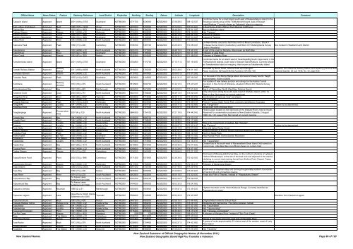
Official Name Name Status Feature Statutory Reference Land District Projection Northing Easting Datum Latitude Longitude Description<br />
Confirmed name for a small island south-east <strong>of</strong> Rukawahakura Island in the<br />
Comment<br />
Takawini Island Approved Island 2001 (149) p.3705 Southland NZTM2000 4771700 1236300 NZGD2000 47 06 28 S 168 12 22 E Breaksea Islands group <strong>of</strong> the Titi/Muttonbird Island, east <strong>of</strong> Stewart<br />
Island/Rakiura. Currently shown as Takiwiwini Island on mapping<br />
Taki-a-Maru (Fish Reef) Approved Reef 1985 (155) p.3636 Otago NZTM2000 4970200 1435300 NZGD2000 45 24 08 S 170 53 44 E A Reef Some 4-5km <strong>of</strong>fshore from Moeraki Lighthouse<br />
Takirau Bay Approved Bay 1979 (42) p.1553 North Auckland NZTM2000 5924200 1780200 NZGD2000 36 48 39 S 175 01 13 E Bay on Waiheke Island<br />
Takirau Stream Approved Stream 1941 (HON) p.32 Gisborne NZTM2000 5734200 2065600 NZGD2000 38 25 09 S 178 19 55 E Not "Takerau"<br />
Takitimu Forest Approved Forest 1950 (70) p.1989 Southland NZTM2000 4922800 1206200 NZGD2000 45 44 10 S 167 56 17 E Instead <strong>of</strong> Takitimo<br />
Takitimu Mountains Approved Range 1950 (70) p.1989 Southland NZTM2000 4931000 1199300 NZGD2000 45 39 31 S 167 51 24 E Instead <strong>of</strong> Takitimo<br />
Takou River Approved River 1943 (HON) p.32 North Auckland NZTM2000 6115600 1684900 NZGD2000 35 05 56 S 173 55 53 E<br />
On Main Divide, one and a half miles north <strong>of</strong> Mount Livinstone. Block II<br />
Takrouna Peak Approved Peak 1956 (17) p.406 Canterbury NZTM2000 5186700 1395100 NZGD2000 43 26 40 S 170 28 04 E Torlesse Survey District (Canterbury) and Block XVI Waitangitaona Survey<br />
District (Westland)<br />
Also located in Westland Land District<br />
Takutairaroa Approved Bay 1932 (HON) p.32 North Auckland NZTM2000 5925100 1773300 NZGD2000 36 48 15 S 174 56 33 E A part <strong>of</strong> the coast on Motuihe. Also known as North Bay<br />
Talbot River Approved River 1979 (42) p.1553 Southland NZTM2000 5030500 1195400 NZGD2000 44 45 52 S 167 53 15 E Tributary <strong>of</strong> Joes River<br />
Talus Creek Approved Stream 1953 (67) p.1920 Nelson NZTM2000 5332300 1516000 NZGD2000 42 09 25 S 171 58 60 E Tributary <strong>of</strong> Waitahu River<br />
Confirmed name for an island west <strong>of</strong> Taukihepa/Big South Cape Island in the<br />
Tamaitemioka Island Approved Island 2001 (149) p.3705 Southland NZTM2000 4754800 1170700 NZGD2000 47 13 11 S 167 19 45 E Titi/Muttonbird Islands, south-west <strong>of</strong> Stewart Island/Rakiura. Currently shown<br />
as Tamaitemioka Island on mapping. Also known as Takaitemioka Island<br />
Tamaki Railway Station Approved<br />
Railway<br />
Station<br />
<strong>2011</strong> (168) p.4698 North Auckland NZTM2000 5915600 1765200 NZGD2000 36 53 28 S 174 51 14 E<br />
Bounded by Morrin Road, Jellicoe Road and Pilkington<br />
Road, Auckland, NZTopo50 BA32-Auckland, GR 652 156.<br />
Alteration from Marama Railway Station and replacing previous <strong>New</strong><br />
<strong>Zealand</strong> Gazette, 29 July 1948, No. 42, page 939.<br />
Tamatatui Stream Approved Stream 1943 (HON) p.32 North Auckland NZTM2000 6115700 1647800 NZGD2000 35 06 01 S 173 31 28 E<br />
Tamatea Peak Approved Peak 1976 (110) p.2453 Southland NZTM2000 4923600 1145800 NZGD2000 45 41 31 S 167 09 59 E<br />
For the peak in the Merrie Range above and west <strong>of</strong> Dusky Sound. Height<br />
approximately 1634m (5360ft)<br />
Tamihana Approved<br />
Railway<br />
Junction<br />
1972 (18) p.379 South Auckland NZTM2000 5819900 1840700 NZGD2000 37 44 12 S 175 43 54 E<br />
For location <strong>of</strong> new railway junction and sidings for the Kaimai Tunnel<br />
deviation in the vicinity <strong>of</strong> Waharoa, situated in Block XIII, Wairere Survey<br />
District<br />
Tamuakawawe Bay Approved Bay 1991 (32) p.687 Marlborough NZTM2000 5450000 1672400 NZGD2000 41 05 53 S 173 51 44 E Bay S <strong>of</strong> Tiaroa Bay, North West Bay, Pelorus Sound<br />
Tanerore Cove Approved Cove 2004 (33) p.751 North Auckland NZTM2000 5923100 1782600 NZGD2000 36 49 13 S 175 02 50 E<br />
Very small cove along the south-west coast <strong>of</strong> Waiheke Island, within Te<br />
Akau o Hine. Not named on current map/chart<br />
Tangahoe River Approved River 1986 (89) p.2487 Taranaki NZTM2000 5609900 1715200 NZGD2000 39 39 11 S 174 20 34 E Confirmation <strong>of</strong> name as 'river' not stream<br />
Tangaihe Bay Approved Bay 1941 (HON) p.32 Gisborne NZTM2000 5830600 2066300 NZGD2000 37 33 13 S 178 16 38 E Not "Taongeiho"<br />
Tangata Maunga Approved Peak 1987 (163) p.4458 Wellington NZTM2000 5452200 1823900 NZGD2000 41 03 02 S 175 39 51 E Peak in Tararua State Forest Park, presently identified as Taungata<br />
Tangatieke Approved Locality 1941 (HON) p.32 Hawke's Bay NZTM2000 5660200 1907700 NZGD2000 39 09 11 S 176 33 38 E Not "Tangarieke" Position to be determined<br />
Tangihau Point Approved Point 1988 (206) p.5173 North Auckland NZTM2000 5917200 1727500 NZGD2000 36 52 57 S 174 25 51 E Small point north <strong>of</strong> Erangi Point<br />
Tangitanginga Approved<br />
Conservation<br />
Area<br />
2007 (4) p.120 North Auckland NZTM2000 5864300 1754100 NZGD2000 37 21 19 S 174 44 24 E<br />
Historic place located on the right bank <strong>of</strong> the Waikato River, near its mouth.<br />
Reserved for conservation purposes by <strong>New</strong> <strong>Zealand</strong> Gazette, 2 August<br />
1990, No. 132, page 2742. Not named on current mapping<br />
Tangitu Bay Approved Bay 1943 (HON) p.32 North Auckland NZTM2000 6108200 1695700 NZGD2000 35 09 52 S 174 03 03 E<br />
Tangitu Point Approved Point 1940 (HON) p.32 North Auckland NZTM2000 6097900 1708600 NZGD2000 35 15 22 S 174 11 38 E<br />
Tangoio Approved Locality 1930 (HON) p.32 Hawke's Bay NZTM2000 5639700 1937400 NZGD2000 39 19 35 S 176 54 50 E This is the correct form <strong>of</strong> spelling. Not "Tongoio"<br />
Tanguru Approved Locality 1941 (HON) p.32 Hawke's Bay NZTM2000 5660500 1903200 NZGD2000 39 09 07 S 176 30 31 E Not "Tanguro" Position to be determined<br />
Tank Gully Approved Valley 1945 (HON) p.32 Canterbury NZTM2000 5182900 1427400 NZGD2000 43 29 13 S 170 51 56 E One mile below Rocky Creek<br />
Tannery Stream Approved Stream 1975 (62) p.1632 Hawke's Bay NZTM2000 5617100 1933700 NZGD2000 39 31 51 S 176 52 56 E Eastern tributary <strong>of</strong> Purimu Stream between Napier and Taradale<br />
Tantalus Peak Approved Peak 1938 (HON) p.32 Otago NZTM2000 5056500 1221400 NZGD2000 44 32 43 S 168 14 02 E North <strong>of</strong> Niobe Peak<br />
Taoka Icefall Approved Ice Fall 1939 (HON) p.32 Southland NZTM2000 5041500 1206300 NZGD2000 44 40 18 S 168 01 59 E Near Karetai Peak, Central Darran Mountains<br />
Tapapanui Approved Trig Station 1944 (HON) p.32 Gisborne NZTM2000 5724700 2028800 NZGD2000 38 31 22 S 177 55 04 E<br />
Taparahaia Approved Locality 1943 (HON) p.32 North Auckland NZTM2000 6078400 1715900 NZGD2000 35 25 52 S 174 16 37 E Not "Taparahahe"<br />
Tapatu Bay Approved Bay 2007 (58) p.1514 North Auckland NZTM2000 6219800 1519400 NZGD2000 34 09 35 S 172 07 32 E<br />
Coastal bay at the south-west <strong>of</strong> Manawatāwhi/Great Island. Not named on<br />
current map. Little Bear Bay (not <strong>of</strong>ficial) shown on current chart<br />
Tapeka Point Approved Point 1940 (HON) p.32 North Auckland NZTM2000 6099600 1702000 NZGD2000 35 14 29 S 174 07 16 E<br />
Tapley Stream Approved Stream 1974 (11) p.233 Canterbury NZTM2000 5226200 1547400 NZGD2000 43 06 54 S 172 21 12 E<br />
Point east <strong>of</strong> Motukauatiiti/Corsair Bay, on the northern shoreline <strong>of</strong> Lyttelyon<br />
Tapoa/Erskine Point Approved Point 2003 (73) p.1896 Canterbury NZTM2000 5171300 1575900 NZGD2000 43 36 39 S 172 42 05 E<br />
Harbour/Whakaraupō, at the site <strong>of</strong> the boat club and adjacent to the marina.<br />
Updating to current dual naming format from Erskine Point (Tapoa). Tapoa<br />
Point <strong>of</strong>ficial by 31/03/1949 45:858<br />
Tapokopoko Stream Approved Stream 1944 (HON) p.32 Wellington NZTM2000 5417600 1766800 NZGD2000 41 22 33 S 174 59 41 E Tributary <strong>of</strong> Mukamuka Stream<br />
Tapp Stream Approved Stream 1989 (120) p.3005 North Auckland NZTM2000 5901000 1733100 NZGD2000 37 01 40 S 174 29 47 E<br />
Tapu Bay Approved Bay 1956 (17) p.406 Nelson NZTM2000 5455500 1600800 NZGD2000 41 03 06 S 173 00 34 E<br />
South-west <strong>of</strong> Stephens Bay and forming the generally southern boundaries<br />
<strong>of</strong> Section 96 and a foreshore reserve<br />
Tapu River Approved River 1974 (11) p.233 South Auckland NZTM2000 5903500 1822500 NZGD2000 36 59 18 S 175 30 00 E Flows into Firth <strong>of</strong> Thames. Instead <strong>of</strong> "Waipatukahu Stream"<br />
Tapuaeharuru Bay Approved Bay<br />
Te Arawa Lakes<br />
Settlement Act 2006<br />
South Auckland NZTM2000 5783700 1905700 NZGD2000 38 02 34 S 176 29 00 E<br />
Tapuaekura Bay Approved Bay<br />
Te Arawa Lakes<br />
Settlement Act 2006<br />
South Auckland NZTM2000 5784000 1899300 NZGD2000 38 02 32 S 176 24 38 E<br />
Tapuae-o-Uenuku Approved Mountain 1988 (2) p.31 Marlborough NZTM2000 5350400 1654800 NZGD2000 41 59 47 S 173 39 42 E<br />
Highest mountain on the Inland Kaikoura Range. Currently identified as<br />
Tapuaenuku on maps<br />
Tapuarau Lagoon Approved Lake<br />
Ngaa Rauru Kiitahi Claims<br />
Settlement Act 2005<br />
Taranaki NZTM2000 5588400 1743500 NZGD2000 39 50 32 S 174 40 38 E Alteration from Hawkens Lagoon<br />
Tapuareroutuutu Approved Rock 1983 (18) p.409 Nelson NZTM2000 5467900 1662800 NZGD2000 40 56 15 S 173 44 46 E Original Maori name for Chicot Rock<br />
Tapuata Railway Siding Approved Railway Line 1930 (HON) p.32 Hawke's Bay NZTM2000 5543400 1862200 NZGD2000 40 13 08 S 176 04 53 E Woodville and Dannevirke. This name replaces Tamaki<br />
Tapuihikitia Approved Locality 1941 (HON) p.32 Gisborne NZTM2000 5734400 2022400 NZGD2000 38 26 19 S 177 50 19 E Not "Tapuihikitea"<br />
Taputeranga Approved Locality 1941 (HON) p.32 Hawke's Bay NZTM2000 5624000 1930500 NZGD2000 39 28 13 S 176 50 30 E Not "Tapu-te-rangi"<br />
Tapuwaeorongokako Approved Point 1941 (HON) p.33 Gisborne NZTM2000 5715200 2052900 NZGD2000 38 35 46 S 178 11 57 E Not "Tapuwae-o-rangokoko"<br />
Tar Pot Creek Approved Stream 1975 (62) p.1632 Westland NZTM2000 5081700 1254700 NZGD2000 44 20 09 S 168 40 07 E A tributary <strong>of</strong> Waipara River. Instead <strong>of</strong> "Bun Tuck Creek"<br />
Tara Approved Trig Station 1944 (HON) p.33 Canterbury NZTM2000 5188100 1515600 NZGD2000 43 27 19 S 171 57 24 E<br />
Tara Haoa Range Approved Range 1994 (42) p.1574 Canterbury NZTM2000 5151800 1448500 NZGD2000 43 46 17 S 171 07 03 E Range <strong>of</strong> mountains along the west side <strong>of</strong> Rangitata River<br />
Tara Rocks Approved Rock 1972 (18) p.379 North Auckland NZTM2000 6026800 1754400 NZGD2000 35 53 27 S 174 42 38 E<br />
A group <strong>of</strong> rocks approximately 23 chains west <strong>of</strong> the western coast <strong>of</strong> Lady<br />
Alice Island<br />
Taraire Stream Approved Stream 1943 (HON) p.33 North Auckland NZTM2000 6115200 1677300 NZGD2000 35 06 11 S 173 50 53 E<br />
Tarakeha Approved Trig Station 1941 (HON) p.33 Gisborne NZTM2000 5787900 1989200 NZGD2000 37 58 23 S 177 25 49 E Not "Tarakeho"<br />
<strong>New</strong> <strong>Zealand</strong> <strong>Names</strong><br />
<strong>New</strong> <strong>Zealand</strong> <strong>Gazetteer</strong> <strong>of</strong> Official Geographic <strong>Names</strong> (8 <strong>November</strong> <strong>2011</strong>)<br />
<strong>New</strong> <strong>Zealand</strong> Geographic Board Ngā Pou Taunaha o Aotearoa Page 96 <strong>of</strong> 120


