

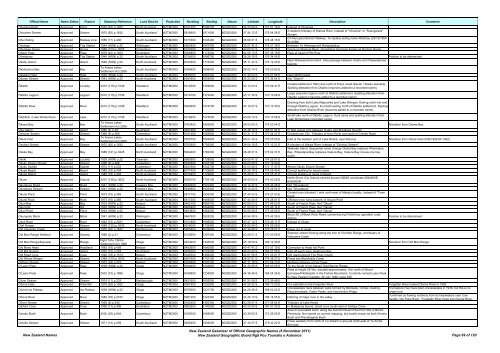
Gazetteer of New Zealand Names - 3 November 2011
Gazetteer of New Zealand Names - 3 November 2011
Gazetteer of New Zealand Names - 3 November 2011

Create successful ePaper yourself
Turn your PDF publications into a flip-book with our unique Google optimized e-Paper software.
Official Name Name Status Feature Statutory Reference Land District Projection Northing Easting Datum Latitude Longitude Description Comment<br />
Ohotutea Point Approved Point 1953 (67) p.1920 North Auckland NZTM2000 6191500 1586700 NZGD2000 34 25 04 S 172 51 19 E Instead <strong>of</strong> Ohututea<br />
Ohourere Stream Approved Stream 1975 (62) p.1632 South Auckland NZTM2000 5818900 1871600 NZGD2000 37 44 13 S 176 04 56 E<br />
A western tributary <strong>of</strong> Wairoa River. Instead <strong>of</strong> "Ohouere" or "Ruangarara"<br />
Stream<br />
Ohui Siding Approved Railway Line 1956 (17) p.406 South Auckland NZTM2000 5771600 1933400 NZGD2000 38 08 31 S 176 48 15 E<br />
On Murupara Branch Railway. To replace siding name Waiohau (22/12/1954<br />
80:2088)<br />
Ohuinga Approved Trig Station 1944 (HON) p.22 Wellington NZTM2000 5582900 1867500 NZGD2000 39 51 42 S 176 07 38 E Between Te Hekenga and Rangioteatua<br />
Ohuriawa Gorge Approved Gorge 1989 (120) p.3005 Canterbury NZTM2000 5232900 1563700 NZGD2000 43 03 21 S 172 33 15 E Gorge on Waipara River. Sometimes has been known as Doctors Gorge.<br />
Oilskin Pass Approved Pass 1979 (42) p.1553 Southland NZTM2000 5009800 1173000 NZGD2000 44 56 13 S 167 35 18 E Pass at head <strong>of</strong> Pitt River<br />
Oiraraorao Approved Trig Station 1944 (HON) p.22 South Auckland NZTM2000 5734500 1896700 NZGD2000 38 29 19 S 176 24 06 E Position to be determined<br />
Okahu Island Approved Island 1936 (HON) p.22 North Auckland NZTM2000 6104500 1710000 NZGD2000 35 11 47 S 174 12 30 E<br />
Near Waewaetorea Island. Also passage between Okahu and Waewaetorea<br />
Islands<br />
Ōkahutoroa Bay Approved Bay<br />
Te Arawa Lakes<br />
Settlement Act 2006<br />
South Auckland NZTM2000 5784600 1898400 NZGD2000 38 02 14 S 176 23 60 E<br />
Okaparu Reef Approved Reef 1939 (HON) p.22 South Auckland NZTM2000 5835000 1897200 NZGD2000 37 35 03 S 176 21 56 E Near Motiti Island<br />
Okarari Stream Approved Stream 1943 (HON) p.22 North Auckland NZTM2000 6083400 1654600 NZGD2000 35 23 29 S 173 36 04 E Not "Okariri"<br />
Ōkārito Approved Locality 2010 (115) p.3108 Westland NZTM2000 5210500 1369600 NZGD2000 43 13 23 S 170 09 47 E<br />
Ōkārito Lagoon Approved Lagoon 2010 (115) p.3108 Westland NZTM2000 5214150 1374000 NZGD2000 43 11 30 S 170 13 06 E<br />
Ōkārito River Approved River 2010 (115) p.3108 Westland NZTM2000 5209300 1374700 NZGD2000 43 14 07 S 170 13 30 E<br />
Coastal settlement 18km due north <strong>of</strong> Franz Josef Glacier / Waiau township.<br />
Spelling alteration from Okarito (macrons added to a recorded name).<br />
Large estuarine lagoon north <strong>of</strong> Ōkārito settlement. Spelling alteration from<br />
Okarito Lagoon (macrons added to a recorded name).<br />
Draining from both Lake Mapourika and Lake Wahapo, flowing north into and<br />
through Ōkārito Lagoon, its mouth exiting north <strong>of</strong> Ōkārito settlement. Spelling<br />
alteration from Okarito River (macrons added to a recorded name).<br />
Ōkāritoiti / Lake Windermere Approved Lake 2010 (115) p.3108 Westland NZTM2000 5218400 1375000 NZGD2000 43 09 13 S 170 13 58 E<br />
Small lake north <strong>of</strong> Ōkārito Lagoon. Dual name and spelling alteration from<br />
Lake Windemere (recorded name).<br />
Ōkawa Bay Approved Bay<br />
Te Arawa Lakes<br />
Settlement Act 2006<br />
South Auckland NZTM2000 5783400 1892600 NZGD2000 38 02 60 S 176 20 04 E Alteration from Okawa Bay<br />
Oke Island Approved Island 1950 (4) p.39 Southland NZTM2000 4927900 1120800 NZGD2000 45 38 12 S 166 51 04 E In Wet Jacket Arm between Dusky and Breaksea Sounds<br />
Okeover Stream Approved Stream 1968 (9) p.268 Canterbury NZTM2000 5181200 1565800 NZGD2000 43 31 17 S 172 34 37 E Christchurch City. Tributary <strong>of</strong> Avon River just south <strong>of</strong> Creyke Road<br />
Ōkere Inlet Approved Bay<br />
Te Arawa Lakes<br />
Settlement Act 2006<br />
South Auckland NZTM2000 5785700 1893800 NZGD2000 38 01 44 S 176 20 50 E Inlet at the western end <strong>of</strong> Lake Rotoiti, near Rotorua Alteration from Okere Inlet (3/06/1999 64:1492)<br />
Okohau Stream Approved Stream 1975 (62) p.1632 South Auckland NZTM2000 5783900 1793500 NZGD2000 38 04 19 S 175 12 21 E A tributary <strong>of</strong> Waipa River. Instead <strong>of</strong> "Okuhau Stream"<br />
Waiheke Island. Sequential name change Okoka Bay replaces Wharetana<br />
Okoka Bay Approved Bay 1988 (141) p.3245 North Auckland NZTM2000 5924400 1782300 NZGD2000 36 48 31 S 175 02 37 E Bay, Wharetana Bay replaces Oakura Bay, Oakura Bay moves one bay<br />
south.<br />
Okoki Approved Locality 1939 (HON) p.22 Taranaki NZTM2000 5680900 1728600 NZGD2000 39 00 41 S 174 29 07 E<br />
Okuku Downs Stream Approved Stream 1968 (9) p.268 Canterbury NZTM2000 5232600 1545100 NZGD2000 43 03 26 S 172 19 33 E<br />
Okuku Saddle Approved Saddle 1974 (11) p.233 Canterbury NZTM2000 5231600 1542700 NZGD2000 43 03 58 S 172 17 47 E Above Okuku Downs Stream<br />
Okupe Beach Approved Beach 1985 (18) p.404 North Auckland NZTM2000 6077400 1729600 NZGD2000 35 26 18 S 174 25 40 E Correct spelling for beach name<br />
Okupe Island Approved Island 1985 (18) p.404 North Auckland NZTM2000 6076400 1729600 NZGD2000 35 26 51 S 174 25 41 E Correct spelling <strong>of</strong> name <strong>of</strong> Island<br />
Okura Approved Suburb 2007 (138) p.3623 North Auckland NZTM2000 5939100 1754100 NZGD2000 36 40 53 S 174 43 29 E<br />
North Shore City Suburb centred around NZMG coordinate 2664600E<br />
6500900N<br />
Okurakura Road Approved Road 1941 (HON) p.22 Hawke's Bay NZTM2000 5649300 1920400 NZGD2000 39 14 47 S 176 42 45 E Not "Ohurakura"<br />
Okurakura Stream Approved Stream 1941 (HON) p.22 Hawke's Bay NZTM2000 5649900 1926400 NZGD2000 39 14 20 S 176 46 54 E Not "Ohurakura"<br />
Okurei Point Approved Point 1973 (15) p.365 South Auckland NZTM2000 5817100 1905300 NZGD2000 37 44 33 S 176 27 53 E<br />
Coastal point situated 1 mile north-east <strong>of</strong> Maketu locality. Instead <strong>of</strong> "Town<br />
Point"<br />
Okurei Rock Approved Rock 1973 (15) p.365 South Auckland NZTM2000 5817200 1905500 NZGD2000 37 44 30 S 176 28 01 E Offshore rock lying easterly <strong>of</strong> Okurei Point<br />
Okuri Bay Approved Bay 1933 (HON) p.22 Nelson NZTM2000 5462100 1665700 NZGD2000 40 59 23 S 173 46 52 E South <strong>of</strong> French Pass. Not "Okure"<br />
Okuri Hill Approved Hill 1933 (HON) p.22 Nelson NZTM2000 5460900 1664800 NZGD2000 41 00 02 S 173 46 14 E South <strong>of</strong> French Pass. Not "Okure"<br />
Okuri Point Approved Point 1933 (HON) p.22 Nelson NZTM2000 5463800 1664500 NZGD2000 40 58 28 S 173 45 60 E South <strong>of</strong> French Pass. Not "Okure"<br />
Okurupatu Block Approved Block 1941 (HON) p.22 Wellington NZTM2000 5467600 1828200 NZGD2000 40 54 39 S 175 42 35 E<br />
Block SE <strong>of</strong> Black Rock Road, containing trig Pukehinau (geodetic code:<br />
A3CQ)<br />
Position to be determined<br />
Okuti River Approved River 1962 (73) p.2021 Canterbury NZTM2000 5151800 1585500 NZGD2000 43 47 12 S 172 49 11 E Instead <strong>of</strong> Okute<br />
Olaf Stream Approved Stream 1989 (120) p.3005 North Auckland NZTM2000 5916000 1732400 NZGD2000 36 53 34 S 174 29 09 E<br />
Old Claverley Creek Approved Stream 1975 (62) p.1632 Marlborough NZTM2000 5285400 1639600 NZGD2000 42 34 58 S 173 28 57 E Flows out to coast<br />
Old Man Range Wetland Approved Swamp 1988 (2) p.31 Canterbury NZTM2000 5125900 1387400 NZGD2000 43 59 21 S 170 20 56 E<br />
Swampy stream flowing along the foor <strong>of</strong> Old Man Range, at tributary <strong>of</strong><br />
Irishmans Creek<br />
Old Man Range/Kopuwai Approved Range<br />
Ngāi Tahu Claims<br />
Settlement Act 1998<br />
Otago NZTM2000 4973200 1303000 NZGD2000 45 19 54 S 169 12 35 E Alteration from Old Man Range<br />
Old Mans Head Approved Headland 1983 (18) p.409 Nelson NZTM2000 5483600 1680600 NZGD2000 40 47 41 S 173 57 19 E Correction to Head not Point<br />
Old Mill Nugget Approved Island 1970 (10) p.297 Southland NZTM2000 4795000 1229200 NZGD2000 46 53 42 S 168 07 55 E Islet <strong>of</strong>f west coast, Halfmoon Bay<br />
Old Road Cove Approved Cove 1992 (78) p.1513 Nelson NZTM2000 5345300 1466200 NZGD2000 42 01 59 S 171 23 01 E Old road tunnel S Fox River mouth<br />
Old Whare Stream Approved Stream 1989 (120) p.3005 North Auckland NZTM2000 5907900 1743100 NZGD2000 36 57 51 S 174 36 27 E Flows into Big Muddy Creek<br />
Oldham Stream Approved Stream 1972 (18) p.379 Nelson NZTM2000 5329400 1592200 NZGD2000 42 11 15 S 172 54 20 E Northern tributary <strong>of</strong> Cat Creek<br />
O'Leary Pass Approved Pass 1938 (HON) p.22 Otago NZTM2000 5059400 1203800 NZGD2000 44 30 35 S 168 00 56 E To the South <strong>of</strong> Ian Massif, Dart Barrier Range<br />
Peak at height 2570m, situated approximately 1km north <strong>of</strong> Mount<br />
O'Leary Peak Approved Peak 2003 (73) p.1896 Otago NZTM2000 5049800 1235800 NZGD2000 44 36 46 S 168 24 36 E Earnslaw/Pikitakatahi in the Forbes Mountains. Currently named Leary Peak<br />
by <strong>New</strong> <strong>Zealand</strong> Gazette, 29 July 1948, page 939<br />
Oliver Stream Approved Stream 1974 (11) p.233 Marlborough NZTM2000 5421900 1655500 NZGD2000 41 21 09 S 173 39 48 E<br />
Olivine Falls Approved Waterfall 1975 (62) p.1632 Otago NZTM2000 5067900 1220000 NZGD2000 44 26 32 S 168 13 29 E For waterfall on the Forgotten River Forgotten River named Olivine River in 1982<br />
Olivine Ice Plateau Approved Ice Plateau 1938 (HON) p.22 Otago NZTM2000 5070000 1231700 NZGD2000 44 25 46 S 168 22 22 E<br />
Crevasseless neve between walls formed by Blockade, Climax, Destiny,<br />
Passchendaele, Gable Peaks, and Intervention Ridge<br />
The feature may have been crevasseless in 1938, but this is no<br />
longer true<br />
Olivine River Approved River 1982 (76) p.2163 Otago NZTM2000 5061200 1222300 NZGD2000 44 30 13 S 168 14 55 E Defining <strong>of</strong> major river in the valley<br />
Confirmed as flowing northerly from its headwaters near Cow<br />
Saddle, into Pyke River. Forgotten River flows into Olivine River.<br />
Olliver Stream Approved Stream 1969 (8) p.240 Canterbury NZTM2000 5182400 1450300 NZGD2000 43 29 47 S 171 08 54 E Tributary <strong>of</strong> Lake Heron<br />
Olphert Cove Approved Cove 1956 (17) p.406 Southland NZTM2000 4953200 1140500 NZGD2000 45 25 24 S 167 07 35 E In Malaspina Sound. Small cove south-east <strong>of</strong> Solitary Cone<br />
Area <strong>of</strong> covenated bush, along the Summit Road <strong>of</strong> the Port Hills <strong>of</strong> Banks<br />
Omahu Bush Approved Bush 2000 (35) p.804 Canterbury NZTM2000 5165300 1569000 NZGD2000 43 39 53 S 172 36 56 E Peninsula. Not named on current mapping, but locally known as both Omahu<br />
Bush and Prendergasts Bush<br />
Omahu Stream Approved Stream 1971 (13) p.259 South Auckland NZTM2000 5845400 1839200 NZGD2000 37 30 27 S 175 42 22 E<br />
Flows westerly from north <strong>of</strong> Tui stream in are just north-east <strong>of</strong> Te Aroha<br />
Borough<br />
<strong>New</strong> <strong>Zealand</strong> <strong>Names</strong><br />
<strong>New</strong> <strong>Zealand</strong> <strong>Gazetteer</strong> <strong>of</strong> Official Geographic <strong>Names</strong> (8 <strong>November</strong> <strong>2011</strong>)<br />
<strong>New</strong> <strong>Zealand</strong> Geographic Board Ngā Pou Taunaha o Aotearoa Page 69 <strong>of</strong> 120


