

Gazetteer of New Zealand Names - 3 November 2011
Gazetteer of New Zealand Names - 3 November 2011
Gazetteer of New Zealand Names - 3 November 2011

Create successful ePaper yourself
Turn your PDF publications into a flip-book with our unique Google optimized e-Paper software.
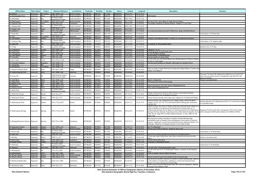
Official Name Name Status Feature Statutory Reference Land District Projection Northing Easting Datum Latitude Longitude Description Comment<br />
Te Rokotai Approved Trig Station 1945 (HON) p.35 North Auckland NZTM2000 5961200 1711500 NZGD2000 36 29 17 S 174 14 41 E<br />
Te Rotoharakeke Point Approved Point 1988 (93) p.2239 South Auckland NZTM2000 5830300 1900700 NZGD2000 37 37 31 S 176 24 26 E Motiti Island<br />
Te Rotoiti Bay Approved Bay<br />
Te Arawa Lakes<br />
Settlement Act 2006<br />
South Auckland NZTM2000 5784500 1913300 NZGD2000 38 01 59 S 176 34 10 E<br />
Te Rotomanoao Approved Trig Station 1974 (100) p.2163 North Auckland NZTM2000 6105400 1661300 NZGD2000 35 11 33 S 173 40 24 E For site <strong>of</strong> Trig. 125 in Block IX, Kaeo Survey District<br />
Te Ruahine Point Approved Point 1972 (18) p.379 Canterbury NZTM2000 5140600 1597500 NZGD2000 43 53 16 S 172 58 08 E The eastern headland <strong>of</strong> Akaroa Harbour. Instead <strong>of</strong> "Truini Point"<br />
Te Ruapeka Bay Approved Bay<br />
Te Arawa Lakes<br />
Settlement Act 2006<br />
South Auckland NZTM2000 5775100 1884500 NZGD2000 38 07 38 S 176 14 44 E<br />
Te Ruatahi Islet Approved Island 1943 (HON) p.35 North Auckland NZTM2000 6075300 1730000 NZGD2000 35 27 26 S 174 25 57 E<br />
Te Ruatarore Approved Bay 1971 (13) p.259 Marlborough NZTM2000 5448300 1704700 NZGD2000 41 06 35 S 174 14 49 E For small bay located just south <strong>of</strong> Ship Cove, Queen Charlotte Sound<br />
Te Ruato Bay Approved Bay<br />
Te Arawa Lakes<br />
Settlement Act 2006<br />
South Auckland NZTM2000 5782400 1901100 NZGD2000 38 03 22 S 176 25 54 E Confirmation <strong>of</strong> Te Ruato Bay<br />
Te Tahi Approved Trig Station 1944 (HON) p.35 Gisborne NZTM2000 5695100 1983500 NZGD2000 38 48 34 S 177 24 58 E<br />
Te Tahi Stream Approved Stream 1970 (10) p.297 South Auckland NZTM2000 5787300 1787400 NZGD2000 38 02 34 S 175 08 08 E Tributary <strong>of</strong> the Mangati Stream, in Block VII, Pirongia Survey District<br />
Te Tapahoro Bay Approved Bay<br />
Te Arawa Lakes<br />
Settlement Act 2006<br />
South Auckland NZTM2000 5767700 1906100 NZGD2000 38 11 12 S 176 29 41 E Confirmation <strong>of</strong> Te Tapahoro Bay<br />
Te Tawa Hill Approved Hill 1940 (HON) p.36 North Auckland NZTM2000 6100600 1714400 NZGD2000 35 13 52 S 174 15 26 E On Section 2F Hauai Rawhiti Block<br />
Te Tī Bay Approved Bay<br />
Te Arawa Lakes<br />
Settlement Act 2006<br />
South Auckland NZTM2000 5786300 1896200 NZGD2000 38 01 21 S 176 22 27 E Alteration from Te Ti Bay<br />
Te Ti Mangonui Approved Locality 1943 (HON) p.36 North Auckland NZTM2000 6110500 1691600 NZGD2000 35 08 39 S 174 00 20 E Instead <strong>of</strong> "Te Tii"<br />
Te Titoki Point Approved Point 2004 (33) p.751 North Auckland NZTM2000 5989500 1784200 NZGD2000 36 13 19 S 175 02 58 E Prominent point on south-west coast<br />
Te Toiokawharu Approved Hill 1941 (HON) p.36 North Auckland NZTM2000 5905700 1736700 NZGD2000 36 59 06 S 174 32 10 E On the Waitakere Ranges<br />
Te Toka Stream Approved Stream 1973 (15) p.365 South Auckland NZTM2000 5900000 1833500 NZGD2000 37 01 02 S 175 37 29 E Small tributary <strong>of</strong> Waiwawa River<br />
Te Toroa Bay Approved Bay 1985 (18) p.404 North Auckland NZTM2000 6100100 1717800 NZGD2000 35 14 07 S 174 17 41 E Correct spelling <strong>of</strong> name <strong>of</strong> Bay<br />
Te Tuhi Track Approved Track 1974 (100) p.2163 South Auckland NZTM2000 5816600 1856100 NZGD2000 37 45 44 S 175 54 26 E<br />
For the track over the Kaimai Range from Whakamarama to Okauia. Instead<br />
<strong>of</strong> "Tui" or "Tuhi Track"<br />
Te Tumurae Headland Approved Headland 1932 (HON) p.36 North Auckland NZTM2000 5925500 1772700 NZGD2000 36 48 02 S 174 56 09 E Northernmost headland on Motuihe. Also known as Cemetery Point<br />
Te Uenga Bay Approved Bay 1940 (HON) p.36 North Auckland NZTM2000 6097700 1712900 NZGD2000 35 15 27 S 174 14 28 E<br />
Te Umukukupa Approved Trig Station 1943 (HON) p.36 North Auckland NZTM2000 6131800 1663700 NZGD2000 34 57 16 S 173 41 52 E<br />
Te Umukuri (Wellers Rock) Approved Rock 1987 (62) p.1964 Otago NZTM2000 4925800 1422300 NZGD2000 45 47 55 S 170 42 48 E<br />
Rock on coast <strong>of</strong> Otago Peninsula, fronting onto Otago Harbour. Current map<br />
shows "Te-U-Mukuri"<br />
Te Upokoohinepaki Point Approved Point 1941 (HON) p.36 Gisborne NZTM2000 5798400 2079500 NZGD2000 37 50 09 S 178 26 50 E<br />
Te Urenui Pā Approved Pā<br />
Ngāti Mutanga Claims<br />
Settlement Act 2006<br />
Taranaki NZTM2000 5683100 1720900 NZGD2000 38 59 35 S 174 23 46 E<br />
The name 'Te Urenui Pā' replaces the reference to “Te Urinui Pā”,<br />
which was incorrectly shown on topographic map 260-Q19, grid<br />
reference 325445<br />
Te Uwhi Block Approved Block 1943 (HON) p.36 North Auckland NZTM2000 6090900 1706500 NZGD2000 35 19 10 S 174 10 18 E Block II, Russell SD Position to be determined<br />
Te Waha Point Approved Point 1989 (62) p.1435 North Auckland NZTM2000 5911400 1729300 NZGD2000 36 56 05 S 174 27 07 E Prominent point north <strong>of</strong> Piha locality<br />
Te Wahapu Inlet Approved Bay 1940 (HON) p.36 North Auckland NZTM2000 6094100 1702100 NZGD2000 35 17 28 S 174 07 22 E<br />
Te Waharoa Approved Bay 1988 (206) p.5173 North Auckland NZTM2000 5918200 1727500 NZGD2000 36 52 25 S 174 25 50 E Name change from 'The Gut'. North <strong>of</strong> Raetahinga Point<br />
Te Waharoa Point Approved Point 1988 (206) p.5173 North Auckland NZTM2000 5918200 1727500 NZGD2000 36 52 25 S 174 25 50 E Point north <strong>of</strong> Raetahinga Point<br />
Te Waiiti Point Approved Point<br />
Te Arawa Lakes<br />
Settlement Act 2006<br />
South Auckland NZTM2000 5782600 1904600 NZGD2000 38 03 11 S 176 28 17 E<br />
Te Waikohare Range Approved Range 2004 (33) p.751 North Auckland NZTM2000 5990300 1785400 NZGD2000 36 12 52 S 175 03 45 E<br />
Range running south-west from Mount Hauturu and located between<br />
Waipawa Stream and Te Waikohare Stream<br />
Te Waikohare Stream Approved Stream 2004 (33) p.751 North Auckland NZTM2000 5990600 1785900 NZGD2000 36 12 42 S 175 04 05 E Stream flowing towards south-west coast, adjacent to Te Waikohare Range<br />
Te Waikoropupū River Approved Stream 2010 (173) p.4271 Nelson NZTM2000 5479200 1582600 NZGD2000 40 50 17 S 172 47 37 E<br />
Te Waikoropupū Springs Approved Springs 2010 (115) p.3108 Nelson NZTM2000 5478100 1580500 NZGD2000 40 50 52 S 172 46 07 E<br />
Te Waipapa/Diamond Harbour Approved Harbour 2003 (73) p.1896 Canterbury NZTM2000 5169700 1578200 NZGD2000 43 37 31 S 172 43 47 E<br />
Flowing easterly into Takaka River from Walker Ridge. NZTopo50 BP24-<br />
Takaka, source: GR 734 772 to NZTopo50 BN24-Collingwood, confluence:<br />
GR 826 792.<br />
Spelling alteration from Waikoropupu River (“Te” and macron added<br />
to a recorded name).<br />
Natural springs, 3km west <strong>of</strong> Takaka, within Pupu Springs Scenic Reserve (a<br />
name proposed to be altered by the Department <strong>of</strong> Conservation to Te<br />
Waikoropupū Springs Scenic Reserve). Spelling alteration from Waikoropupu Replaces ID 6154 and ID 583. Corrigendum 2010 (120) p.3228,<br />
Springs and Pupu Springs. Replacing previous <strong>New</strong> <strong>Zealand</strong> Gazette, 29 July which changed the NZTopo50 reference from BP24 to PN24.<br />
1948, No. 42, page 939, and <strong>New</strong> <strong>Zealand</strong> Gazette, 12 June 1980, No. 66,<br />
page 1752.<br />
Bay along the southern shoreline <strong>of</strong> Lyttelton Harbour/Whakaraupō,<br />
immediately west <strong>of</strong> Stoddart Point and adjacent to the locality <strong>of</strong> Diamond<br />
Harbour. Updating to current dual naming format from Diamond Harbour (Te<br />
Waipapa). Replaces Te Waipapa Harbour (31/03/1949 22:858)<br />
Te Waipuhake Stream Approved Stream 1941 (HON) p.36 Gisborne NZTM2000 5819800 2077400 NZGD2000 37 38 41 S 178 24 34 E Not "Te Waipuhaki"<br />
Te Wairere Stream Approved Stream 2004 (33) p.751 North Auckland NZTM2000 5992500 1785400 NZGD2000 36 11 40 S 175 03 43 E Stream west <strong>of</strong> Mount Hauturu, flowing to west coast<br />
Te Wairoa Bay Approved Bay<br />
Te Arawa Lakes<br />
Settlement Act 2006<br />
South Auckland NZTM2000 5784500 1911000 NZGD2000 38 02 02 S 176 32 36 E Confirmation <strong>of</strong> Te Wairoa Bay<br />
Te Waite Bay Approved Bay 1970 (10) p.297 North Auckland NZTM2000 6057000 1739400 NZGD2000 35 37 15 S 174 32 21 E Next to the southern headland at entrance to Tutukaka Harbour<br />
Te Weheka Approved Beach 1966 (1) p.18 Southland NZTM2000 4752400 1177300 NZGD2000 47 14 44 S 167 24 49 E<br />
On the east coast <strong>of</strong> Big South Cape Island. Muttonbirding block landing<br />
place<br />
Position to be determined<br />
Te Wera Peak Approved Peak 1939 (HON) p.36 Southland NZTM2000 5043000 1207800 NZGD2000 44 39 33 S 168 03 11 E Central Darran Mountains<br />
Te Weraiti Stream Approved Stream 1975 (62) p.1632 South Auckland NZTM2000 5809300 1851400 NZGD2000 37 49 45 S 175 51 23 E A tributary <strong>of</strong> Mangakara Stream<br />
Te Weta Bay Approved Bay<br />
Te Arawa Lakes<br />
Settlement Act 2006<br />
South Auckland NZTM2000 5784900 1894100 NZGD2000 38 02 09 S 176 21 03 E Confirmation <strong>of</strong> Te Weta Bay<br />
Te Wetenga Approved High Point 1980 (66) p.1752 Wellington NZTM2000 5662300 1863100 NZGD2000 39 08 56 S 176 02 40 E For high point in Kaimanawa State Forest<br />
Te Whakapatiki Approved Hill 1973 (15) p.365 South Auckland NZTM2000 5738800 1754200 NZGD2000 38 29 09 S 174 46 05 E<br />
For hill at the sourve <strong>of</strong> Te Whakapatiki Stream, a tributary <strong>of</strong> the Awakino<br />
River<br />
Te Whakarekaiwi Approved Point 1987 (62) p.1964 Otago NZTM2000 4924000 1424900 NZGD2000 45 48 55 S 170 44 46 E Point on eastern coast <strong>of</strong> Otago Peninsula<br />
Te Wharau Stream Approved Stream 1989 (120) p.3005 North Auckland NZTM2000 5922400 1732200 NZGD2000 36 50 06 S 174 28 57 E<br />
Te Wharau Stream Approved Stream 1988 (206) p.5173 Canterbury NZTM2000 5166300 1574900 NZGD2000 43 39 21 S 172 41 19 E Stream flowing through Orton Bradley Park to Charteris Bay<br />
Bay along the southern shoreline <strong>of</strong> Lyttelton Harbour/Whakaraupō, adjacent<br />
Te Wharau/Charteris Bay Approved Bay 2003 (73) p.1896 Canterbury NZTM2000 5167300 1575400 NZGD2000 43 38 49 S 172 41 42 E to the locality <strong>of</strong> Charteris Bay. Updating to current dual naming format.<br />
Shown on current mapping as Charteris Bay<br />
Te Wharepouri Mark Approved Place 2004 (33) p.751 Wellington NZTM2000 5471700 1873200 NZGD2000 40 51 37 S 176 14 29 E<br />
Historic place along the Wairarapa coast, 5km north <strong>of</strong> Castlepoint. Spelling<br />
correction from Waipori's Mark<br />
<strong>New</strong> <strong>Zealand</strong> <strong>Names</strong><br />
<strong>New</strong> <strong>Zealand</strong> <strong>Gazetteer</strong> <strong>of</strong> Official Geographic <strong>Names</strong> (8 <strong>November</strong> <strong>2011</strong>)<br />
<strong>New</strong> <strong>Zealand</strong> Geographic Board Ngā Pou Taunaha o Aotearoa Page 102 <strong>of</strong> 120


