Stefan Wirtz Vom Fachbereich VI (Geographie/Geowissenschaften ...
Stefan Wirtz Vom Fachbereich VI (Geographie/Geowissenschaften ...
Stefan Wirtz Vom Fachbereich VI (Geographie/Geowissenschaften ...

Create successful ePaper yourself
Turn your PDF publications into a flip-book with our unique Google optimized e-Paper software.
Experimentelle Rinnenerosionsforschung vs. Modellkonzepte – Quantifizierung der hydraulischen und erosiven Wirksamkeit von Rinnen<br />
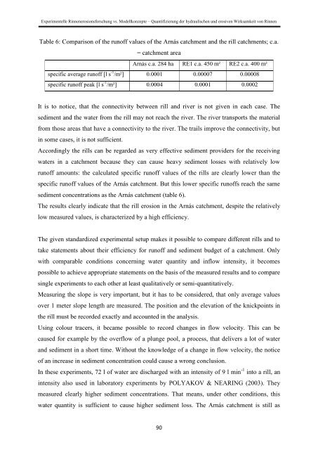
Table 6: Comparison of the runoff values of the Arnás catchment and the rill catchments; c.a.<br />
= catchment area<br />
Arnás c.a. 284 ha RE1 c.a. 450 m² RE2 c.a. 400 m²<br />
specific average runoff [l s -1 /m²] 0.0001 0.00007 0.00008<br />
specific runoff peak [l s -1 /m²] 0.0004 0.0001 0.0002<br />
It is to notice, that the connectivity between rill and river is not given in each case. The<br />
sediment and the water from the rill may not reach the river. The river transports the material<br />
from those areas that have a connectivity to the river. The trails improve the connectivity, but<br />
in some cases, it is not sufficient.<br />
Accordingly the rills can be regarded as very effective sediment providers for the receiving<br />
waters in a catchment because they can cause heavy sediment losses with relatively low<br />
runoff amounts: the calculated specific runoff values of the rills are clearly lower than the<br />
specific runoff values of the Arnás catchment. But this lower specific runoffs reach the same<br />
sediment concentrations as the Arnás catchment (table 6).<br />
The results clearly indicate that the rill erosion in the Arnás catchment, despite the relatively<br />
low measured values, is characterized by a high efficiency.<br />
The given standardized experimental setup makes it possible to compare different rills and to<br />
take statements about their efficiency for runoff and sediment budget of a catchment. Only<br />
with comparable conditions concerning water quantity and inflow intensity, it becomes<br />
possible to achieve appropriate statements on the basis of the measured results and to compare<br />
single experiments to each other at least qualitatively or semi-quantitatively.<br />
Measuring the slope is very important, but it has to be considered, that only average values<br />
over 1 meter slope length are measured. The position and the elevation of the knickpoints in<br />
the rill must be recorded exactly and accounted in the analysis.<br />
Using colour tracers, it became possible to record changes in flow velocity. This can be<br />
caused for example by the overflow of a plunge pool, a process, that delivers a lot of water<br />
and sediment in a short time. Without the knowledge of a change in flow velocity, the notice<br />
of an increase in sediment concentration could cause a wrong conclusion.<br />
In these experiments, 72 l of water are discharged with an intensity of 9 l min -1 into a rill, an<br />
intensity also used in laboratory experiments by POLYAKOV & NEARING (2003). They<br />
measured clearly higher sediment concentrations. That means, under other conditions, this<br />
water quantity is sufficient to cause higher sediment loss. The Arnás catchment is still as<br />
90