Innovation in Global Power - Parsons Brinckerhoff
Innovation in Global Power - Parsons Brinckerhoff
Innovation in Global Power - Parsons Brinckerhoff

Create successful ePaper yourself
Turn your PDF publications into a flip-book with our unique Google optimized e-Paper software.
Hydropower – New Technologies, New Considerations<br />
http://www.pbworld.com/news_events/publications/network/<br />
Dam Safety: State-of-the-Art Methodology<br />
Demonstrates that Costly Remediation is<br />
Not Needed<br />
By Jay Greska, Boston, Massachusetts, 1-617-960-5021, greska@pbworld.com; and Bryce Mochrie, 1-617-960-4971, mochrie@pbworld.com.<br />
Updated federal regulations<br />
require owners of hydroelectric<br />
dams <strong>in</strong> the USA to<br />
evaluate the safety of their<br />
facilities under all potential<br />
failure modes. In the case<br />
of one of the Tapoco Project<br />
dams where there was<br />
concern about potential<br />
scour, the authors based<br />
their <strong>in</strong>vestigation on<br />
recent research that<br />
applies specifically to jet<br />
streams, versus gradually<br />
varied flow. This approach<br />
was used successfully on this<br />
project and is applicable to<br />
other scour impact areas<br />
subjected to free fall<strong>in</strong>g water.<br />
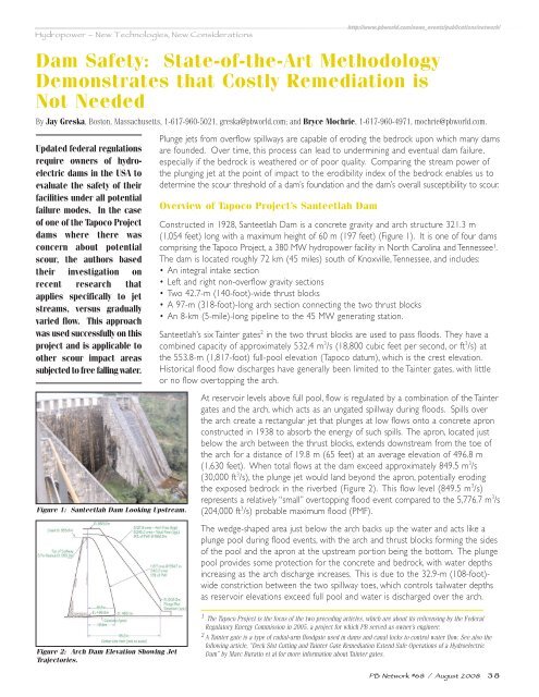
Figure 1: Santeetlah Dam Look<strong>in</strong>g Upstream.<br />
Plunge jets from overflow spillways are capable of erod<strong>in</strong>g the bedrock upon which many dams<br />
are founded. Over time, this process can lead to underm<strong>in</strong><strong>in</strong>g and eventual dam failure,<br />
especially if the bedrock is weathered or of poor quality. Compar<strong>in</strong>g the stream power of<br />
the plung<strong>in</strong>g jet at the po<strong>in</strong>t of impact to the erodibility <strong>in</strong>dex of the bedrock enables us to<br />
determ<strong>in</strong>e the scour threshold of a dam’s foundation and the dam’s overall susceptibility to scour.<br />
Overview of Tapoco Project’s Santeetlah Dam<br />
Constructed <strong>in</strong> 1928, Santeetlah Dam is a concrete gravity and arch structure 321.3 m<br />
(1,054 feet) long with a maximum height of 60 m (197 feet) (Figure 1). It is one of four dams<br />
compris<strong>in</strong>g the Tapoco Project, a 380 MW hydropower facility <strong>in</strong> North Carol<strong>in</strong>a and Tennessee 1 .<br />
The dam is located roughly 72 km (45 miles) south of Knoxville,Tennessee, and <strong>in</strong>cludes:<br />
• An <strong>in</strong>tegral <strong>in</strong>take section<br />
• Left and right non-overflow gravity sections<br />
• Two 42.7-m (140-foot)-wide thrust blocks<br />
• A 97-m (318-foot)-long arch section connect<strong>in</strong>g the two thrust blocks<br />
• An 8-km (5-mile)-long pipel<strong>in</strong>e to the 45 MW generat<strong>in</strong>g station.<br />
Santeetlah’s six Ta<strong>in</strong>ter gates 2 <strong>in</strong> the two thrust blocks are used to pass floods. They have a<br />
comb<strong>in</strong>ed capacity of approximately 532.4 m 3 /s (18,800 cubic feet per second, or ft 3 /s) at<br />
the 553.8-m (1,817-foot) full-pool elevation (Tapoco datum), which is the crest elevation.<br />
Historical flood flow discharges have generally been limited to the Ta<strong>in</strong>ter gates, with little<br />
or no flow overtopp<strong>in</strong>g the arch.<br />
At reservoir levels above full pool, flow is regulated by a comb<strong>in</strong>ation of the Ta<strong>in</strong>ter<br />
gates and the arch, which acts as an ungated spillway dur<strong>in</strong>g floods. Spills over<br />
the arch create a rectangular jet that plunges at low flows onto a concrete apron<br />
constructed <strong>in</strong> 1938 to absorb the energy of such spills. The apron, located just<br />
below the arch between the thrust blocks, extends downstream from the toe of<br />
the arch for a distance of 19.8 m (65 feet) at an average elevation of 496.8 m<br />
(1,630 feet). When total flows at the dam exceed approximately 849.5 m 3 /s<br />
(30,000 ft 3 /s), the plunge jet would land beyond the apron, potentially erod<strong>in</strong>g<br />
the exposed bedrock <strong>in</strong> the riverbed (Figure 2). This flow level (849.5 m 3 /s)<br />
represents a relatively “small” overtopp<strong>in</strong>g flood event compared to the 5,776.7 m 3 /s<br />
(204,000 ft 3 /s) probable maximum flood (PMF).<br />
The wedge-shaped area just below the arch backs up the water and acts like a<br />
plunge pool dur<strong>in</strong>g flood events, with the arch and thrust blocks form<strong>in</strong>g the sides<br />
of the pool and the apron at the upstream portion be<strong>in</strong>g the bottom. The plunge<br />
pool provides some protection for the concrete and bedrock, with water depths<br />
<strong>in</strong>creas<strong>in</strong>g as the arch discharge <strong>in</strong>creases. This is due to the 32.9-m (108-foot)-<br />
wide constriction between the two spillway toes, which controls tailwater depths<br />
as reservoir elevations exceed full pool and water is discharged over the arch.<br />
Figure 2: Arch Dam Elevation Show<strong>in</strong>g Jet<br />
Trajectories.<br />
1 The Tapoco Project is the focus of the two preced<strong>in</strong>g articles, which are about its relicens<strong>in</strong>g by the Federal<br />
Regulatory Energy Commission <strong>in</strong> 2005, a project for which PB served as owner’s eng<strong>in</strong>eer.<br />
2 A Ta<strong>in</strong>ter gate is a type of radial-arm floodgate used <strong>in</strong> dams and canal locks to control water flow. See also the<br />
follow<strong>in</strong>g article, “Deck Slot Cutt<strong>in</strong>g and Ta<strong>in</strong>ter Gate Remediation Extend Safe Operations of a Hydroelectric<br />
Dam” by Marc Buratto et al for more <strong>in</strong>formation about Ta<strong>in</strong>ter gates.<br />
PB Network #68 / August 2008 38