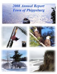
Town of Phippsburg 2012 Annual Report
Town of Phippsburg 2012 Annual Report
Town of Phippsburg 2012 Annual Report

Create successful ePaper yourself
Turn your PDF publications into a flip-book with our unique Google optimized e-Paper software.
84<br />
<strong>2012</strong> ANNUAL REPORT<br />
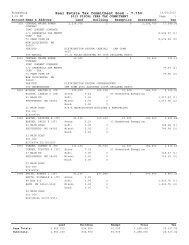
<strong>Town</strong>-Owned Property<br />
Map Lot Acres Identification<br />
7 2 .18 Rt. #209 (Dromore)<br />
7 3 .25 Rt. #209 (Dromore)<br />
7 22 .18 Rt. #209 (Dromore)<br />
7 23 .14 Rt. #209 (Dromore)<br />
8 29 2.1 Center (Totman Library)*<br />
10 18 .27 Parkers Neck (Rising Sun)<br />
10 20 .55 Parkers Neck (Rising Sun/old ferry landing)<br />
11 2 .44 Corner-P.H. Rd. & Sam Day Hill Rd.<br />
11 13 .15 Parker Head Rd.*<br />
11 15 .08 Parker Head Rd.*<br />
11 21 .21 Parker Head Rd.(septic field)<br />
11 22 .23 Parker Head Rd. (formerly DeGolyer)<br />
11 25 .14 Parker Head Rd. (formerly Sutcliffe)<br />
11 28 57.7 Parker Head Rd. (former sludge field)<br />
11 39 .05 Parker Head Rd.<br />
11 45 .14 Parker Head Rd. (<strong>Town</strong> Landing)*<br />
11 52 .06 Parker Head Rd. (Sleeper boat-house lot)<br />
13 48 .25 Cox's Head (former Norton)<br />
16 32 .23 Perkins Farm Lane (former Navy Rake Station)<br />
25 16 .21 Small Point-Alliquippa <strong>Town</strong> Landing<br />
28 3 88.0 Totman Cove and Forest (Sebasco Beach)*<br />
31 60 1.5 Sebasco - "Acre Lot" Landing<br />
34 3-1 40.48 Basin (Waterfront Parcel)**<br />
37 3 1.03 Meadowbrook <strong>Town</strong> Landing*<br />
42 10-1 2.6 Cushman Field<br />
42 11-1 3.63 Basin (Hatch Road Section Two)**<br />
42 22-1 20.04 Basin (School Parcel)**<br />
42 38 5.0 <strong>Town</strong> Hall/Fire Station Lot*<br />
42 39 .50 Hatch Point<br />
43 8 8.59 Sam Day Hill Rd.<br />
43 33 45.58 Transfer Station/Salt Shed<br />
43 35 .80 Sam Day Hill Rd. (former Small)<br />
45 11 59.0 Off Popham Cross Rd.*<br />
45 24 45.0 Off Parker Head Rd.<br />
45 58 20.0 Off Popham Cross Rd.<br />
45 59 125.5 Off Popham Cross Rd.*<br />
45 60 30.0 Off Popham Cross Rd.*<br />
Map 4 Established R/W to <strong>Town</strong> Landing Old Ferry Road<br />
Map 13 Established R/W to <strong>Town</strong> Landing- Cox's Head<br />
Map 27 Established R/W to <strong>Town</strong> Landing Cat Cove-West Point<br />
* - Adjusted acreage for accuracy as per deeds/surveys ** - New properties for <strong>2012</strong>