- Page 1 and 2: Agricultural Drought Indices Procee
- Page 3 and 4: © World Meteorological Organizatio
- Page 5 and 6: Agricultural Drought Indices Procee
- Page 7 and 8: Preface With the world population p
- Page 9 and 10: Segura River Basin: Spanish Pilot R
- Page 11 and 12: Table 3. Segura River Basin resourc
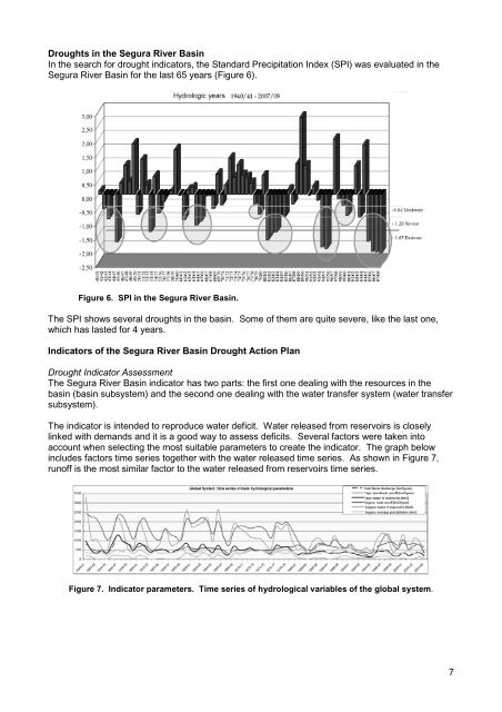
- Page 13: Figure 5. Segura River Basin water
- Page 17 and 18: Table 5. Analysis of drought impact
- Page 19 and 20: Even with this drought action plan
- Page 21 and 22: that complicates water management b
- Page 23 and 24: Understanding the nature of the haz
- Page 25 and 26: Figure 2. U.S. Drought Monitor for
- Page 27 and 28: Summary Drought is a creeping pheno
- Page 29 and 30: Agricultural Drought—WMO Perspect
- Page 31 and 32: c) CAgM-VI (Washington, USA, 1974)
- Page 33 and 34: an unusually large moisture demand.
- Page 35 and 36: the-clock nature of WIGOS, the anal
- Page 37 and 38: and temporal variations in drought
- Page 39 and 40: Support to Regional Institutions WM
- Page 41 and 42: Williams, M.A.J. and R.C. Balling,
- Page 43 and 44: The day after Black Sunday, an Asso
- Page 45 and 46: Meteorological research at these in
- Page 47 and 48: United States is sent to the Secret
- Page 49 and 50: Palmer Drought Severity Index (PDSI
- Page 51 and 52: PDSI as an operational index since
- Page 53 and 54: WAOB, GIS has become an important t
- Page 55 and 56: USDM as the official criteria for F
- Page 57 and 58: Monitoring Drought Risks in India w
- Page 59 and 60: areas recording large incidences of
- Page 61 and 62: The analysis revealed that out of 1
- Page 63 and 64: Figure 3. Aridity anomaly chart of
- Page 65 and 66:
Figure 5. Progression of surface we
- Page 67 and 68:
Agricultural Drought Indices in Cur
- Page 69 and 70:
Meteorological and Agricultural Dro
- Page 71 and 72:
Palmer Drought Severity Index Adapt
- Page 73 and 74:
Accumulated WD and WS April 2010 Ac
- Page 75 and 76:
Soil Water Storage (SWS) September
- Page 77 and 78:
hydrological characteristics, and c
- Page 79 and 80:
Agricultural Drought Indices in Cur
- Page 81 and 82:
application of drought indices has
- Page 83 and 84:
The Value of Crop and Pasture Simul
- Page 85 and 86:
To assist, many agriculturally-spec
- Page 87 and 88:
change in Australia. The PDSI provi
- Page 89 and 90:
Mpelasoka, F.S., M.A. Collier, R. S
- Page 91 and 92:
supply and demand are fully taken i
- Page 93 and 94:
In Germany, the Deutsche Wetterdien
- Page 95 and 96:
creation of a system of European su
- Page 97 and 98:
The second index is extracted from
- Page 99 and 100:
Figure 7. Standardized Soil Water I
- Page 101 and 102:
References Durand, Y., E. Brun, L.
- Page 103 and 104:
Europe around the Iberian Peninsula
- Page 105 and 106:
The incoming rainwater and the atmo
- Page 107 and 108:
Figure 6. Example of SPI map for a
- Page 109 and 110:
The 1991-95 Drought Episode A long-
- Page 111 and 112:
adverse climatic impacts on agricul
- Page 113 and 114:
Agricultural Drought Indices in the
- Page 115 and 116:
efers to deficiencies in surface an
- Page 117 and 118:
Figure 5. Time series of standardiz
- Page 119 and 120:
Limitations of Agricultural Drought
- Page 121 and 122:
Incorporating a Composite Approach
- Page 123 and 124:
Figure 3. Daily gridded SPI by regi
- Page 125 and 126:
The North American Drought Monitor:
- Page 127 and 128:
process (a) emulates natural cycles
- Page 129 and 130:
Summary Given the complexity that d
- Page 131 and 132:
alance models cannot be applied for
- Page 133 and 134:
60 50 40 Error 30 20 Systematic Err
- Page 135 and 136:
In Figure 4, examples of the normal
- Page 137 and 138:
Figure 7. Water balance for Brazil,
- Page 139 and 140:
The soil water balance module in th
- Page 141 and 142:
Water Balance as a Tool for Agricul
- Page 143 and 144:
Conclusions The topics discussed pr
- Page 145 and 146:
Use of Crop Models for Drought Anal
- Page 147 and 148:
The parameters used in crop simulat
- Page 149 and 150:
a model for cassava and potato (Tsu
- Page 151 and 152:
ackground. The system’s most impo
- Page 153 and 154:
management. In research, however, p
- Page 155 and 156:
Smajstrla, A.G. 1990. Technical Man
- Page 157 and 158:
Monitoring Regional Drought Conditi
- Page 159 and 160:
Figure 2 represents the regression
- Page 161 and 162:
Conclusions and Discussion Several
- Page 163 and 164:
Experiences During the Drought Peri
- Page 165 and 166:
During the years 2007 and 2008, for
- Page 167 and 168:
Figure 6. Management simulation mod
- Page 169 and 170:
Figure 9. Irrigation diversions in
- Page 171 and 172:
References Andreu, J., Ferrer Polo,
- Page 173 and 174:
Table 2. MERIS spectral bands MDS N
- Page 175 and 176:
Figure 6. Spanish NSDIE during 2008
- Page 177 and 178:
References Gu, Y., J. F. Brown, J.
- Page 179 and 180:
Agricultural Drought Indices: Summa
- Page 181 and 182:
Table 1. Agricultural drought indic
- Page 183 and 184:
Accumulated Rainfall Deficits In an
- Page 185 and 186:
Heim (2002) notes that as recently
- Page 187 and 188:
each calendar day in the base perio
- Page 189 and 190:
The purpose of the climatic charact
- Page 191 and 192:
to compare moisture conditions at d
- Page 193 and 194:
Table 6. Overview of different drou
- Page 195 and 196:
have been adopted because of the av
- Page 197 and 198:
TCI = 100 (T max - T) / (T max - T
- Page 199 and 200:
Figure 1. The February 8, 2011, US
- Page 201 and 202:
8) There is a universal interest in
- Page 203 and 204:
Mavromatis, T. 2007. Drought index
- Page 205:
Agricultural Drought Indices Procee