

Agricultural Drought Indices - US Department of Agriculture
Agricultural Drought Indices - US Department of Agriculture
Agricultural Drought Indices - US Department of Agriculture

Create successful ePaper yourself
Turn your PDF publications into a flip-book with our unique Google optimized e-Paper software.
in DEWS in countries such as Brazil, China, Hungary, India, Nigeria, South Africa, and the United<br />
States, but also noted the activities <strong>of</strong> regional drought monitoring centers in eastern and southern<br />
Africa and efforts in West Asia and North Africa. Shortcomings <strong>of</strong> current DEWS were noted in the<br />
following areas:<br />
• data networks—inadequate density and data quality <strong>of</strong> meteorological and hydrological<br />
networks and lack <strong>of</strong> data networks on all major climate and water supply parameters;<br />
• data sharing—inadequate data sharing between government agencies and the high cost <strong>of</strong><br />
data limit the application <strong>of</strong> data in drought preparedness, mitigation, and response;<br />
• early warning system products—data and information products are <strong>of</strong>ten not user friendly<br />
and users are <strong>of</strong>ten not trained in the application <strong>of</strong> this information to decision making;<br />
• drought forecasts—unreliable seasonal forecasts and the lack <strong>of</strong> specificity <strong>of</strong> information<br />
provided by forecasts limit the use <strong>of</strong> this information by farmers and others;<br />
• drought monitoring tools—inadequate indices for detecting the early onset and end <strong>of</strong><br />
drought, although the Standardized Precipitation Index (SPI) was cited as an important new<br />
monitoring tool to detect the early emergence <strong>of</strong> drought;<br />
• integrated drought/climate monitoring—drought monitoring systems should be integrated<br />
and based on multiple indicators to fully understand drought magnitude, spatial extent, and<br />
impacts;<br />
• drought impact assessment methodology—lack <strong>of</strong> impact assessment methodology<br />
hinders impact estimates and the activation <strong>of</strong> mitigation and response programs;<br />
• delivery systems—data and information on emerging drought conditions, seasonal<br />
forecasts, and other products are <strong>of</strong>ten not delivered to users in a timely manner;<br />
• global drought early warning system—no historical drought database exists and there is no<br />
global drought assessment product that is based on one or two key indicators, which could<br />
be helpful to international organizations, NGOs, and others.<br />
Participants <strong>of</strong> the expert group meeting on DEWS made several recommendations. Those<br />
recommendations that pertained directly to early warning systems were that these systems should<br />
be considered an integral part <strong>of</strong> drought preparedness and mitigation plans and that priority<br />
should be given to improving existing observation networks and establishing new meteorological,<br />
agricultural, and hydrological networks.<br />
Effective drought monitoring requires the integration <strong>of</strong> a variety <strong>of</strong> indices and indicators. <strong>Indices</strong><br />
commonly used to monitor drought and rainfall conditions include the Standardized Precipitation<br />
Index, deciles, percent <strong>of</strong> normal rainfall/precipitation, the Palmer <strong>Drought</strong> Severity Index, the<br />
Surface Water Supply Index, and the Vegetation Condition Index, among others (see, for example,<br />
the U.S. <strong>Drought</strong> Monitor [http://drought.unl.edu/dm/]). Other indicators <strong>of</strong> drought <strong>of</strong>ten used to<br />
monitor conditions include soil moisture, snowpack, streamflow, groundwater levels, reservoir and<br />
lake levels, vegetation health, and short-, medium-, and long-range forecasts. Remote sensing<br />
<strong>of</strong>fers new and exciting opportunities to monitor drought conditions because <strong>of</strong> higher resolution.<br />
These techniques are especially advantageous in regions lacking adequate weather station<br />
networks.<br />
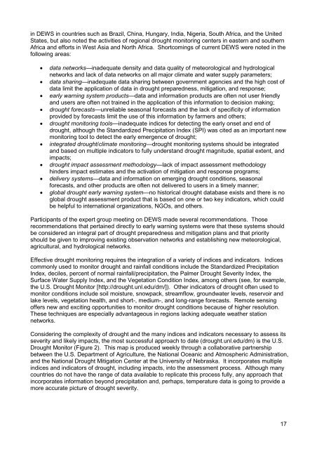
Considering the complexity <strong>of</strong> drought and the many indices and indicators necessary to assess its<br />
severity and likely impacts, the most successful approach to date (drought.unl.edu/dm) is the U.S.<br />
<strong>Drought</strong> Monitor (Figure 2). This map is produced weekly through a collaborative partnership<br />
between the U.S. <strong>Department</strong> <strong>of</strong> <strong>Agriculture</strong>, the National Oceanic and Atmospheric Administration,<br />
and the National <strong>Drought</strong> Mitigation Center at the University <strong>of</strong> Nebraska. It incorporates multiple<br />
indices and indicators <strong>of</strong> drought, including impacts, into the assessment process. Although many<br />
countries do not have the range <strong>of</strong> data available to replicate this process fully, any approach that<br />
incorporates information beyond precipitation and, perhaps, temperature data is going to provide a<br />
more accurate picture <strong>of</strong> drought severity.<br />
17


