

Agricultural Drought Indices - US Department of Agriculture
Agricultural Drought Indices - US Department of Agriculture
Agricultural Drought Indices - US Department of Agriculture

Create successful ePaper yourself
Turn your PDF publications into a flip-book with our unique Google optimized e-Paper software.
y McKee et al. (1993 and 1995). The SPI has undergone rigorous statistical testing (Guttman<br />
1998) and has been shown to be effective in detecting the early emergence <strong>of</strong> drought because it<br />
can be calculated for multiple time scales. This characteristic lends itself well to the initiation <strong>of</strong><br />
mitigation actions to reduce drought impacts.<br />
Another distinguishing feature <strong>of</strong> drought is its duration. <strong>Drought</strong>s usually require a minimum <strong>of</strong> two<br />
to three months to become established but then can continue for months or years. It is quite<br />
common for dryland regions to suffer consecutive drought years, but this may also occur in more<br />
humid climates. The magnitude <strong>of</strong> drought impact is closely related to the timing <strong>of</strong> the onset <strong>of</strong><br />
the precipitation shortage, its intensity, and the duration <strong>of</strong> the event. As droughts extend from one<br />
season to another and from one year to another, potential impacts are magnified since surface and<br />
subsurface water supplies continue to be depleted and a larger number <strong>of</strong> users are affected.<br />
Frequent and multi-year drought events <strong>of</strong>fer no opportunity for natural and managed systems to<br />
recover, a critical problem for fragile arid and semiarid ecosystems.<br />
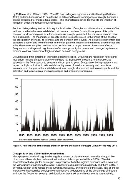
<strong>Drought</strong>s also differ in terms <strong>of</strong> their spatial characteristics. <strong>Drought</strong>s are regional in nature and<br />
may affect millions <strong>of</strong> square kilometers (Figure 1). Because <strong>of</strong> drought’s long duration, its<br />
epicenter shifts from season to season and from year to year. <strong>Drought</strong> monitoring systems must<br />
rely on multiple indicators to adequately identify areas <strong>of</strong> maximum severity and be able to<br />
evaluate how changes in the spatial dimension <strong>of</strong> drought alter current and future impacts and the<br />
activation and termination <strong>of</strong> mitigation actions and emergency programs.<br />
Figure 1. Percent area <strong>of</strong> the United States in severe and extreme drought, January 1895-May 2010.<br />
<strong>Drought</strong> Risk and Vulnerability Assessment<br />
Many people consider drought to be largely a natural or physical event. In reality, drought, like<br />
other natural hazards, has both a natural and a social component (Wilhite 2009). The risk<br />
associated with drought for any region is a product <strong>of</strong> both the region’s exposure to the event and<br />
the vulnerability <strong>of</strong> society to the event. Exposure to drought varies regionally and there is little, if<br />
anything, we can do to reduce the recurrence, frequency, or incidence <strong>of</strong> the event. It is <strong>of</strong> critical<br />
importance that countries develop a comprehensive understanding <strong>of</strong> the climatology <strong>of</strong> drought<br />
and how the frequency, severity, and duration <strong>of</strong> these extreme climatic events vary spatially.<br />
15


