Joint Metoc Handboo - IHMC Ontology and Policy Management
Joint Metoc Handboo - IHMC Ontology and Policy Management
Joint Metoc Handboo - IHMC Ontology and Policy Management
Create successful ePaper yourself
Turn your PDF publications into a flip-book with our unique Google optimized e-Paper software.
7-Navy<br />
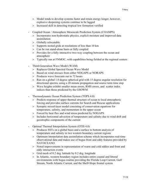
> Model tends to develop systems faster <strong>and</strong> retain energy longer, however,<br />
explosive deepening systems continue to be lagged<br />
> Increased skill in detecting tropical low formation verified<br />
- Coupled Ocean / Atmosphere Mesoscale Prediction System (COAMPS)<br />
> Incorporates non-hydrostatic physics, explicit moisture <strong>and</strong> improved data<br />
assimilation<br />
> Globally relocatable<br />
> Supports nested grids at resolutions of less than 10 km<br />
> Can be run st<strong>and</strong>-alone basis or fully coupled<br />
> Provides for a fully interactive two-way coupling between the ocean <strong>and</strong><br />
atmosphere<br />
> Typically run at FNMOC, with capabilities being fielded at the regional centers<br />
- Third-Generation Wave Model (WAM)<br />
> Replaces Global Spectral Ocean Wave Model<br />
> Based on wind stresses from either NOGAPS or NORAPS<br />
> Produces wave forecasts out to 72 hours<br />
> Run on a global 1.0 degree spherical grid with 15 degree angular resolution for<br />
directional spectra, using a 20 minute propagation <strong>and</strong> source term time step<br />
> Wave heights exhibit smaller mean errors, RMS errors, <strong>and</strong> scatter index<br />
indices than those predicted by the GSOWM<br />
- Thermodynamic Ocean Prediction System (TOPS 4.0)<br />
> Predicts response of upper thermal structure of ocean to local atmospheric<br />
forcing <strong>and</strong> provides surface currents for Search <strong>and</strong> Rescue applications<br />
> Synoptic mixed-layer model consisting of conservation equations for<br />
temperature, salinity, <strong>and</strong> momentum in the upper ocean<br />
> Forced by heat flux <strong>and</strong> wind stress predicted by NOGAPS<br />
> Includes horizontal advection of temperature <strong>and</strong> salinity due to wind drift <strong>and</strong><br />
geostrophic components of the current<br />
- Optimal Thermal Interpolation System (OTIS 4.0)<br />
> Produces SSTs on a global basis <strong>and</strong> a surface to bottom analysis of<br />
temperature <strong>and</strong> salinity in two western boundary current regions<br />
> Optimum interpolation data assimilation scheme which incorporates real-time<br />
observational data <strong>and</strong> makes use of bogus front <strong>and</strong> eddy features provided by<br />
NAVOCEANO<br />
> Noted improvements in representation of warm <strong>and</strong> cold eddies <strong>and</strong> front <strong>and</strong><br />
eddy interaction events<br />
> Grid mesh of 0.2 deg. latitude by 0.2 deg. longitude<br />
> In Atlantic, western boundary region includes entire coastal <strong>and</strong> littoral<br />
environments with bogus routine providing the Florida Loop Current, Gulf<br />
Stream, North Atlantic Current, <strong>and</strong> the Shelf-Slope frontal system<br />
7-13


