(Blue Diamond Road) Corridor Study - Regional Transportation ...
(Blue Diamond Road) Corridor Study - Regional Transportation ...
(Blue Diamond Road) Corridor Study - Regional Transportation ...
Create successful ePaper yourself
Turn your PDF publications into a flip-book with our unique Google optimized e-Paper software.
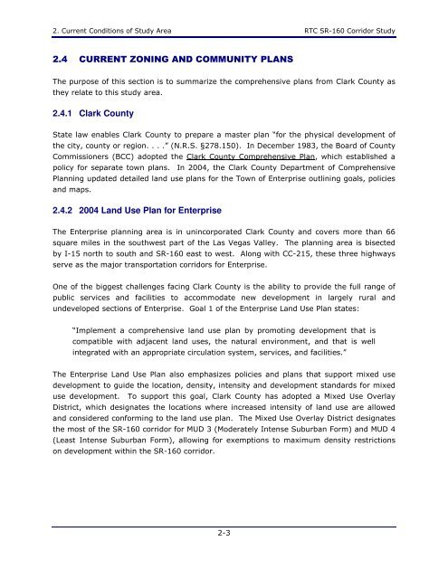
2. Current Conditions of <strong>Study</strong> Area RTC SR-160 <strong>Corridor</strong> <strong>Study</strong><br />
2.4 CURRENT ZONING AND COMMUNITY PLANS<br />
The purpose of this section is to summarize the comprehensive plans from Clark County as<br />
they relate to this study area.<br />
2.4.1 Clark County<br />
State law enables Clark County to prepare a master plan “for the physical development of<br />
the city, county or region. . . .” (N.R.S. §278.150). In December 1983, the Board of County<br />
Commissioners (BCC) adopted the Clark County Comprehensive Plan, which established a<br />
policy for separate town plans. In 2004, the Clark County Department of Comprehensive<br />
Planning updated detailed land use plans for the Town of Enterprise outlining goals, policies<br />
and maps.<br />
2.4.2 2004 Land Use Plan for Enterprise<br />
The Enterprise planning area is in unincorporated Clark County and covers more than 66<br />
square miles in the southwest part of the Las Vegas Valley. The planning area is bisected<br />
by I-15 north to south and SR-160 east to west. Along with CC-215, these three highways<br />
serve as the major transportation corridors for Enterprise.<br />
One of the biggest challenges facing Clark County is the ability to provide the full range of<br />
public services and facilities to accommodate new development in largely rural and<br />
undeveloped sections of Enterprise. Goal 1 of the Enterprise Land Use Plan states:<br />
“Implement a comprehensive land use plan by promoting development that is<br />
compatible with adjacent land uses, the natural environment, and that is well<br />
integrated with an appropriate circulation system, services, and facilities.”<br />
The Enterprise Land Use Plan also emphasizes policies and plans that support mixed use<br />
development to guide the location, density, intensity and development standards for mixed<br />
use development. To support this goal, Clark County has adopted a Mixed Use Overlay<br />
District, which designates the locations where increased intensity of land use are allowed<br />
and considered conforming to the land use plan. The Mixed Use Overlay District designates<br />
the most of the SR-160 corridor for MUD 3 (Moderately Intense Suburban Form) and MUD 4<br />
(Least Intense Suburban Form), allowing for exemptions to maximum density restrictions<br />
on development within the SR-160 corridor.<br />
2-3


