FM 17-98 SCOUT PLATOON
FM 17-98 SCOUT PLATOON
FM 17-98 SCOUT PLATOON

You also want an ePaper? Increase the reach of your titles
YUMPU automatically turns print PDFs into web optimized ePapers that Google loves.
locations during combat operations, and all tactical operations centers (TOC) and command posts (CP)<br />
must carefully track the location of all subordinate elements in relation to all friendly forces.<br />
SECTION 5 — NAVIGATION<br />
MAPS AND OVERLAYS<br />
The most important role of maps and their accompanying overlays is in helping the platoon to understand and<br />
visualize the scheme of maneuver. They are the primary tool the platoon leader uses to organize information<br />
concerning the battlefield and to synchronize his assets once the battle begins. They also provide vehicle commanders<br />
with a visual reference they can consult as needed. The platoon leader must ensure that each vehicle commander has<br />
an updated map with the latest graphic control measures posted on the overlay.<br />
Overlays can be prepared either in traditional fashion or digitally. The platoon leader may receive one or more types of<br />
overlays from the battalion or squadron, covering such areas as maneuver, enemy forces, obstacles, fire support, and<br />
CSS. All of the information is important; the key for the platoon leader is to combine, augment, and declutter the<br />
overlays so the information needed for a specific situation is readily available to the platoon on one simple, combined<br />
overlay.<br />
LAND NAVIGATION<br />
To protect his platoon, the platoon leader must learn to use terrain to his advantage. Land navigation of scout vehicles<br />
requires him to master the technique of terrain association. This entails the ability to identify terrain features on the<br />
ground by the contour intervals depicted on the map. The platoon leader analyzes the terrain using the factors of<br />
OCOKA and identifies major terrain features, contour changes, and man-made structures along his axis of advance.<br />
As the platoon advances, he uses these features to orient the platoon and to associate ground positions with map<br />
locations.<br />
The intellectual concept of battle space is vital to the platoon’s survival during navigation and movement. The platoon<br />
leader must constantly be aware of key terrain and enemy fields of observation and fire that may create danger areas as<br />
the platoon advances. This allows him to modify movement techniques, formations, and routes and to maintain crosstalk<br />
with overwatch elements to ensure the platoon is not surprised by the enemy. (NOTE: Refer to the discussion of<br />
danger areas in Chapter 8 of this manual.)<br />
Navigation under limited visibility conditions is especially challenging. Vehicle thermal sights and night vision<br />
goggles provide assistance, but leaders nonetheless can easily confuse terrain features and become disoriented. The<br />
platoon can employ a variety of techniques and equipment to assist in navigation. These are summarized in the<br />
following paragraphs.<br />
Compass and odometer. This method of navigation entails use of a dismounted compass and the vehicle’s odometer.<br />
Follow these steps:<br />
• Divide the route or operation into legs or parts, each with a unique direction and distance and a checkpoint at<br />
both ends.<br />
• Measure the map distance of each leg or part.<br />
• Determine the magnetic azimuth of each leg or part.<br />
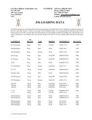
• Develop a chart listing the legs or parts, azimuths, and distances. Write a description of each leg or part. Refer to<br />
Figure 2-12 for an example.<br />
• For each leg or part, move the gun tube to the direction of the magnetic azimuth. Maintain turret stabilization at<br />
all times; do not traverse the turret except at the start of the next leg or part. (NOTE: Use of this technique<br />
places the vehicle crew and the unit at a distinct disadvantage. It reduces the crew’s capability to effectively<br />
scan the surrounding terrain and, in turn, can seriously degrade crew and unit security and situational<br />
awareness.)<br />
• Use the odometer to measure the distance traveled for each leg or part.<br />
• Review the written description of the route to help prevent navigational errors.