- Page 1 and 2: FIELD MANUAL No. 17-98 *FM 17-98 He
- Page 3 and 4: Preface On the ever-changing landsc
- Page 5 and 6: Figure 1-2. HMMWV scout platoon. VE
- Page 7 and 8: Figure 1-4. CFV scout platoon two-s
- Page 9 and 10: Eight-squad organization Figure 1-8
- Page 11 and 12: general have capabilities and limit
- Page 13 and 14: Figure 1-11. HMMWV characteristics.
- Page 15 and 16: tactical and operational considerat
- Page 17 and 18: • Models that depict the enemy’
- Page 19 and 20: Figure 2-4. Example decision suppor
- Page 21 and 22: Figure 2-6. Example R&S tasking mat
- Page 23 and 24: The military decision-making proces
- Page 25 and 26: Step 1 - Receive and analyze the mi
- Page 27 and 28: • Where is the key terrain • Ho
- Page 29 and 30: After the platoon leader has analyz
- Page 31 and 32: leaders have issued their orders, t
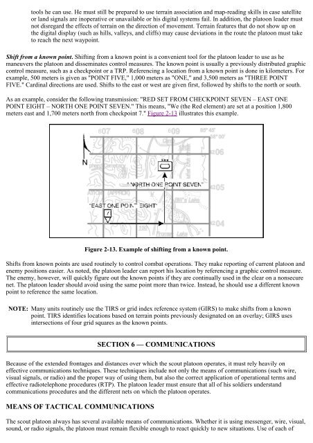
- Page 33 and 34: different colors for friendly and e
- Page 35 and 36: Figure 2-11A. Optimizing battle spa
- Page 37: Figure 2-12. Route chart for compas
- Page 41 and 42: Administrative/logistics. The scout
- Page 43 and 44: • Use a brevity code that reduces
- Page 45 and 46: The scout platoon’s scheme of man
- Page 47 and 48: Figure 3-1. Area reconnaissance usi
- Page 49 and 50: Converging routes method. The patro
- Page 51 and 52: signatures of the vehicle and the l
- Page 53 and 54: In each type of organization, the g
- Page 55 and 56: EXAMPLE OF A ROUTE RECONNAISSANCE F
- Page 57 and 58: Figure 3-8D. Route reconnaissance (
- Page 59 and 60: Figure 3-8H. Route reconnaissance (
- Page 61 and 62: oundaries, an LD, and an LOA or obj
- Page 63 and 64: Figure 3-9D. Zone reconnaissance (c
- Page 65 and 66: Figure 3-9H. Zone reconnaissance (c
- Page 67 and 68: leader feels there may be enemy for
- Page 69 and 70: Figure 3-10D. Area reconnaissance (
- Page 71 and 72: Figure 3-10H. Area reconnaissance (
- Page 73 and 74: troop-leading process (normally a m
- Page 75 and 76: Recommending/executing a course of
- Page 77 and 78: Figure 3-11D. Reconnaissance of a r
- Page 79 and 80: Figure 3-12B. Reconnaissance of an
- Page 81 and 82: Figure 3-12F. Reconnaissance of an
- Page 83 and 84: Figure 3-13A. Infiltration scheme o
- Page 85 and 86: Planning and coordination Figure 3-
- Page 87 and 88: defensive operations, forcing it to
- Page 89 and 90:
CHAPTER 4 Security Operations In se
- Page 91 and 92:
Scouts maintain surveillance from a
- Page 93 and 94:
Redundancy. The platoon leader may
- Page 95 and 96:
most appropriate role for the scout
- Page 97 and 98:
ecause the scouts must move to the
- Page 99 and 100:
Figure 4-9b. Repositioning OPs in d
- Page 101 and 102:
Figure 4-10. Scout and tank team co
- Page 103 and 104:
With his troop commander’s guidan
- Page 105 and 106:
eposition to BP A5. The tank platoo
- Page 107 and 108:
A. OP J maintains contact with the
- Page 109 and 110:
Figure 4-21. Cavalry scout platoon
- Page 111 and 112:
Figure 4-24A. Convoy escort actioni
- Page 113 and 114:
Figure 4-25C. Escort breaking conta
- Page 115 and 116:
The following actions should be tak
- Page 117 and 118:
CHAPTER 5 Other Tactical Operations
- Page 119 and 120:
ACTIONS IN THE ASSEMBLY AREA As soo
- Page 121 and 122:
Checkpoints on a route are used for
- Page 123 and 124:
SECTION 3 — BATTLE HANDOVER AND P
- Page 125 and 126:
movement, movement formation, and e
- Page 127 and 128:
stationary unit is responsible for
- Page 129 and 130:
CHAPTER 6 Combat Support The scout
- Page 131 and 132:
• Scatterable mines. These includ
- Page 133 and 134:
Figure 6-2. Scouts requesting fire
- Page 135 and 136:
The scout platoon leader must be pr
- Page 137 and 138:
Figure 6-8. Attack helicopter batta
- Page 139 and 140:
movement. In addition, the air cava
- Page 141 and 142:
The first action in the handoff pro
- Page 143 and 144:
SECTION 3 — COMBAT ENGINEERS Brig
- Page 145 and 146:
Although passive measures are the f
- Page 147 and 148:
Figure 6-17. Stinger air defense sy
- Page 149 and 150:
sight range of 10,000 meters agains
- Page 151 and 152:
Whatever support the scout platoon
- Page 153 and 154:
should conduct resupply during miss
- Page 155 and 156:
of inspecting, testing, servicing,
- Page 157 and 158:
When a vehicle must be evacuated, t
- Page 159 and 160:
SECTION 5 — PRISONERS EPWs are ex
- Page 161 and 162:
CHAPTER 8 Basic Scout Skills Scouts
- Page 163 and 164:
This type of local security task is
- Page 165 and 166:
• Unobstructed observation of the
- Page 167 and 168:
is located with his vehicle in the
- Page 169 and 170:
Figure 8-7. Sample format and infor
- Page 171 and 172:
In this position, the vehicle comma
- Page 173 and 174:
Figure 8-13. Platoon column formati
- Page 175 and 176:
Figure 8-17. Section vee and wedge
- Page 177 and 178:
BOUNDING OVERWATCH Bounding overwat
- Page 179 and 180:
Figure 8-23. Mounted crest drill. D
- Page 181 and 182:
most vulnerable in wooded areas whe
- Page 183 and 184:
The scouts that are not in contact
- Page 185 and 186:
Maintain contact to support a hasty
- Page 187 and 188:
section/squad leader simply informs
- Page 189 and 190:
Deviation spotting As applied to de
- Page 191 and 192:
Figure 8-27. Bracketing Bracketing
- Page 193 and 194:
CHAPTER 9 Miscellaneous Field Data
- Page 195 and 196:
Figure 9-1. Reconnaissance overlay
- Page 197 and 198:
Figure 9-1. Reconnaissance overlay
- Page 199 and 200:
Figure 9-2. Example of overlay grap
- Page 201 and 202:
• Stretching a string or measurin
- Page 203 and 204:
7 inches = 17.78 centimeters 8 inch
- Page 205 and 206:
the antenna connector on the radio.
- Page 207 and 208:
FOOD AND WATER Water collection Wit
- Page 209 and 210:
Figure 9-7. Enemy weapons, vehicles
- Page 211 and 212:
Figure 9-7. Enemy weapons, vehicles
- Page 213 and 214:
Figure 9-7. Enemy weapons, vehicles
- Page 215 and 216:
Figure 9-7. Enemy weapons, vehicles
- Page 217 and 218:
Figure 9-7. Enemy weapons, vehicles
- Page 219 and 220:
Figure 9-7. Enemy weapons, vehicles
- Page 221 and 222:
Figure 9-7. Enemy weapons, vehicles
- Page 223 and 224:
higher commander’s intent. The sc
- Page 225 and 226:
• Linkup time and location. • P
- Page 227 and 228:
APPENDIX B Nuclear, Biological, and
- Page 229 and 230:
Equipment MOPP level MOPP READY MOP
- Page 231 and 232:
Give the alarm. Have all unmasked s
- Page 233 and 234:
Figure B-1. NBC marking devices. UN
- Page 235 and 236:
contamination remains, so periodic
- Page 237 and 238:
movement in the direction of the co
- Page 239 and 240:
• Once the wing vehicles reach th
- Page 241 and 242:
APPENDIX C Stability and Support Op
- Page 243 and 244:
activities. Examples of these are l
- Page 245 and 246:
Because of the unique requirements
- Page 247 and 248:
US military forces may be tasked fo
- Page 249 and 250:
excellent hasty roadblocks because
- Page 251 and 252:
Figure C-5. Deliberate checkpoint o
- Page 253 and 254:
approaching traffic until it is too
- Page 255 and 256:
Photographic filter Instant cameras
- Page 257 and 258:
• Contact your checkpoint command
- Page 259 and 260:
Figure C-14. Ankle-to-ankle positio
- Page 261 and 262:
CORDON AND SEARCH OPERATIONS When i
- Page 263 and 264:
the armored unit’s mobility, prot
- Page 265 and 266:
APPENDIX D Military Operations on U
- Page 267 and 268:
The friendly commander should try t
- Page 269 and 270:
• It is vulnerable to enemy infan
- Page 271 and 272:
Figure D-3. Gaining a foothold in M
- Page 273 and 274:
Figure D-5. CFV provides support as
- Page 275 and 276:
Figure E-1. Figure E-1. Environment
- Page 277 and 278:
APPENDIX F Risk Management Risk is
- Page 279 and 280:
Moderate (M) Low (L) Expected degra
- Page 281 and 282:
• Thoroughly brief all aspects of
- Page 283 and 284:
APPENDIX G Fratricide Prevention Fr
- Page 285 and 286:
Lapses in individual discipline can
- Page 287 and 288:
target identification before they i
- Page 289 and 290:
Glossary A AA AAR ABF ACE ACR ADA A
- Page 291 and 292:
div DP DPICM DS DST DTD division de
- Page 293 and 294:
I J k ICM ID IEDK IFF IFSAS IPB IR
- Page 295 and 296:
NCO NCOIC NCS NEO NGO NLT NOD nonco
- Page 297 and 298:
RISTA ROE ROI ROUTEREP RP RSI rte R
- Page 299 and 300:
TTP tactics, techniques, and proced
- Page 301 and 302:
ARTEP 17-237-10-MTP Mission Trainin