Orestimba Creek Feasibility Study - Stanislaus County
Orestimba Creek Feasibility Study - Stanislaus County
Orestimba Creek Feasibility Study - Stanislaus County

Create successful ePaper yourself
Turn your PDF publications into a flip-book with our unique Google optimized e-Paper software.
Economics Appendix – Draft Report - <strong>Orestimba</strong> <strong>Creek</strong> <strong>Feasibility</strong> <strong>Study</strong>, <strong>Stanislaus</strong> <strong>County</strong>, California – September 2012<br />
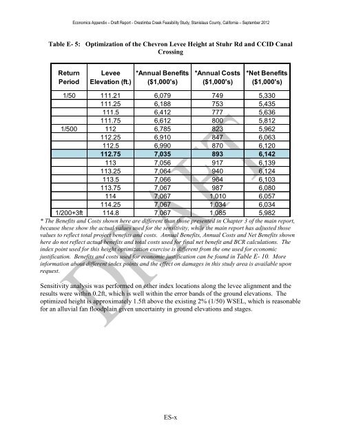
Table E- 5: Optimization of the Chevron Levee Height at Stuhr Rd and CCID Canal<br />
Crossing<br />
Return<br />
Period<br />
Levee<br />
Elevation (ft.)<br />
*Annual Benefits<br />
($1,000's)<br />
*Annual Costs<br />
($1,000's)<br />
*Net Benefits<br />
($1,000's)<br />
1/50 111.21 6,079 749 5,330<br />
111.25 6,188 753 5,435<br />
111.5 6,412 777 5,636<br />
111.75 6,612 800 5,812<br />
1/500 112 6,785 823 5,962<br />
112.25 6,910 847 6,063<br />
112.5 6,990 870 6,120<br />
112.75 7,035 893 6,142<br />
113 7,056 917 6,139<br />
113.25 7,064 940 6,124<br />
113.5 7,066 964 6,103<br />
113.75 7,067 987 6,080<br />
114 7,067 1,010 6,057<br />
114.25 7,067 1,034 6,034<br />
1/200+3ft 114.8 7,067 1,085 5,982<br />
* The Benefits and Costs shown here are different than those presented in Chapter 3 of the main report,<br />
because these show the actual values used for the sensitivity, while the main report has adjusted those<br />
values to reflect total project benefits and costs. Annual Benefits, Annual Costs and Net Benefits shown<br />
here do not reflect actual benefits and total costs used for final net benefit and BCR calculations. The<br />
index point used for this height optimization exercise is different from the one used for economic<br />
justification. Benefits and costs used for economic justification can be found in Table E- 10. More<br />
information about different index points and the effect on damages in this study area is available upon<br />
request.<br />
Sensitivity analysis was performed on other index locations along the levee alignment and the<br />
results were within 0.2ft, which is well within the error bands of the ground elevations. The<br />
optimized height is approximately 1.5ft above the existing 2% (1/50) WSEL, which is reasonable<br />
for an alluvial fan floodplain given uncertainty in ground elevations and stages.<br />
ES-x