

1 Spatial Modelling of the Terrestrial Environment - Georeferencial
1 Spatial Modelling of the Terrestrial Environment - Georeferencial
1 Spatial Modelling of the Terrestrial Environment - Georeferencial

Create successful ePaper yourself
Turn your PDF publications into a flip-book with our unique Google optimized e-Paper software.
94 <strong>Spatial</strong> <strong>Modelling</strong> <strong>of</strong> <strong>the</strong> <strong>Terrestrial</strong> <strong>Environment</strong><br />
processes in fixed grid models (e.g. King and Roig, 1988; Defina et al., 1994; Bates and<br />
Hervouet, 1999; Defina, 2000) using proportionality coefficients based on <strong>the</strong> sub-grid<br />
topography, lack <strong>of</strong> data has usually meant that <strong>the</strong>se coefficients are assumed ra<strong>the</strong>r than<br />
parameterized from actual measurements. Unlike ground survey data, which are frequently<br />
unavailable at even <strong>the</strong> grid resolution, LiDAR data are typically available at a much higher<br />
resolution than most model grids. It is <strong>the</strong>refore possible to use <strong>the</strong> redundant, sub-grid<br />
scale data to directly parameterize <strong>the</strong>se sub-grid scale algorithms and better correct for<br />
wetting and drying effects in two-dimensional Shallow Water models (Bates and Hervouet,<br />
1999; Bates, 2000). Both areas <strong>of</strong> model development are still in <strong>the</strong>ir infancy and fur<strong>the</strong>r<br />
research is required.<br />
5.3.2 <strong>Spatial</strong>ly Distributed Friction Data<br />
The traditional method <strong>of</strong> parameterizing bottom friction in hydraulic models involves<br />
specifying friction factors for floodplain and channel. These are treated as free parameters<br />
to be adjusted to provide <strong>the</strong> best fit between model predictions and observations. As<br />
noted above, use <strong>of</strong> sparse hydrometric data for model calibration means that <strong>the</strong> assigned<br />
parameters are typically spatially and temporally lumped so that one value is used to<br />
represent <strong>the</strong> channel and one to represent <strong>the</strong> floodplain. A more physically-based friction<br />
parameterization can now be obtained using <strong>the</strong> vegetation height data generated from<br />
airborne LiDAR as described in section 5.2.3, which can be used (see Figure 5.3) to specify<br />
an ‘effective’ individual friction factor at each node <strong>of</strong> a computational model (Mason<br />
et al., 2003). A different equation set can be used to model flow resistance at a node<br />
depending on <strong>the</strong> vegetation within <strong>the</strong> node neighbourhood. Thus, for in channel areas<br />
flow resistance is calculated as a function <strong>of</strong> bed material size using <strong>the</strong> relationship <strong>of</strong> Hey<br />
(1979). For short vegetation, such as floodplain grasses and crops, <strong>the</strong> Darcy-Weisbach<br />
friction factor f is modelled using <strong>the</strong> approach <strong>of</strong> Kouwen (1988) described above with <strong>the</strong><br />
term MEI determined using an empirical correlation with vegetation height determined by<br />
Temple (1987). Finally, tall vegetation is treated using <strong>the</strong> method <strong>of</strong> Fathi-Moghadam and<br />
Kouwen (Fathi-Moghadam and Kouwen, 1997; Kouwen and Fathi-Moghadam, 2000). This<br />
calculates <strong>the</strong> hydraulic resistance <strong>of</strong> such vegetation as a linear function <strong>of</strong> velocity. The<br />
surface properties in <strong>the</strong> vicinity <strong>of</strong> each node are <strong>the</strong>n integrated to give a value for f which<br />
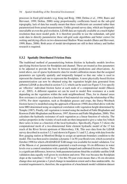
<strong>the</strong>n varies in time as a function <strong>of</strong> <strong>the</strong> local hydraulics. Specifically, Figure 5.3 shows <strong>the</strong><br />
computational mesh <strong>of</strong> a two-dimensional finite element hydraulic model <strong>of</strong> <strong>the</strong> 17 km<br />
reach <strong>of</strong> <strong>the</strong> River Severn upstream <strong>of</strong> Shrewsbury, UK. This uses data from <strong>the</strong> LiDAR<br />
survey described in section 5.2.3 and shown in Figures 5.1 and 5.2, along with data from <strong>the</strong><br />
flow gauging station at Montford Bridge to assign an upstream boundary condition to <strong>the</strong><br />
model. This was <strong>the</strong>n used to simulate a dynamic 1-in 50-year flood event, which occurred in<br />
October 1998 for which a RADARSAT SAR image was available for model validation. Use<br />
<strong>of</strong> <strong>the</strong> Mason et al. parameterization generated a reach-average 16 cm difference in water<br />
levels over a control simulation with a spatially lumped and calibrated friction surface. This<br />
is a significant difference, however, both parameterizations fitted <strong>the</strong> available satellite SAR<br />
validation data equally well given its resolution and error. This was because <strong>the</strong> floodplain<br />
slope at <strong>the</strong> waterline (∼0.03 m m −1 ) for this 50-year event means that a 16-cm elevation<br />
change does not generate a 1 pixel change in inundation extent and is thus undetectable. An<br />
essential requirement is, <strong>the</strong>refore, <strong>the</strong> acquisition <strong>of</strong> a benchmark model validation dataset


