

1 Spatial Modelling of the Terrestrial Environment - Georeferencial
1 Spatial Modelling of the Terrestrial Environment - Georeferencial
1 Spatial Modelling of the Terrestrial Environment - Georeferencial

Create successful ePaper yourself
Turn your PDF publications into a flip-book with our unique Google optimized e-Paper software.
96 <strong>Spatial</strong> <strong>Modelling</strong> <strong>of</strong> <strong>the</strong> <strong>Terrestrial</strong> <strong>Environment</strong><br />
5.3.3 Automatic Mesh Generation<br />
Two-dimensional structured and unstructured grids form <strong>the</strong> basis <strong>of</strong> many flood models.<br />
The automatic mesh generator <strong>of</strong> Horritt (1998) requires <strong>the</strong> meandering position <strong>of</strong> <strong>the</strong> river<br />
channel banks and some (arbitrary) contour to describe <strong>the</strong> extent <strong>of</strong> <strong>the</strong> model domain.<br />
Ra<strong>the</strong>r than digitizing this information from maps, <strong>the</strong> LiDAR segmentation system <strong>of</strong><br />
Cobby et al. (2001) described above can be used to automatically identify any river channel<br />
and provide <strong>the</strong> chainage description <strong>of</strong> its banks in a format that can be used by <strong>the</strong> mesh<br />
generator. Fur<strong>the</strong>rmore, <strong>the</strong> map <strong>of</strong> LiDAR topographic slope is used to define <strong>the</strong> domain<br />
extent contour, so that <strong>the</strong> domain is narrower where steep slopes bound <strong>the</strong> channel than<br />
where <strong>the</strong> floodplain is flat and wide. The number <strong>of</strong> elements in <strong>the</strong> domain is fur<strong>the</strong>r<br />
reduced by using larger elements away from regions <strong>of</strong> high process gradient, for example,<br />
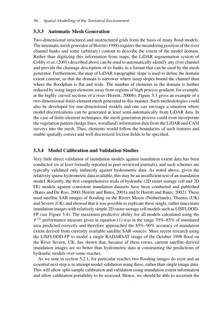
at <strong>the</strong> highly curved sections <strong>of</strong> a river (Horritt, 2000b). Figure 5.3 gives an example <strong>of</strong> a<br />
two-dimensional finite-element mesh generated in this manner. Such methodologies could<br />
also be developed for one-dimensional models and one can envisage a situation where<br />
model discretizations can be generated at least semi-automatically from LiDAR data. In<br />
<strong>the</strong> case <strong>of</strong> finite-element techniques, <strong>the</strong> mesh generation process could even incorporate<br />
<strong>the</strong> vegetation pattern (hedge lines, woodland) information data from <strong>the</strong> LiDAR and CASI<br />
surveys into <strong>the</strong> mesh. Thus, elements would follow <strong>the</strong> boundaries <strong>of</strong> such features and<br />
enable spatially correct and well discretized friction fields to be specified.<br />
5.3.4 Model Calibration and Validation Studies<br />
Very little direct validation <strong>of</strong> inundation models against inundation extent data has been<br />
conducted (or at least formally reported in peer-reviewed journals), and such schemes are<br />
typically validated only indirectly against hydrometric data. As noted above, given <strong>the</strong><br />
relatively sparse hydrometric data available, this may be an insufficient test <strong>of</strong> an inundation<br />
model. Recently, <strong>the</strong> first comprehensive trials <strong>of</strong> hydraulic (2D raster storage cell and 2D<br />
FE) models against consistent inundation datasets have been conducted and published<br />
(Bates and De Roo, 2000; Horritt and Bates, 2001a and b; Horritt and Bates, 2002). These<br />
used satellite SAR images <strong>of</strong> flooding on <strong>the</strong> Rivers Meuse (Ne<strong>the</strong>rlands), Thames (UK)<br />
and Severn (UK) and showed that it was possible to replicate <strong>the</strong>se single, ra<strong>the</strong>r inaccurate<br />
inundation images with relatively simple 2D raster storage cell models such as LISFLOOD-<br />
FP (see Figure 5.4). The maximum predictive ability for all models calculated using <strong>the</strong><br />
F 〈2〉 performance measure given in equation (1) was in <strong>the</strong> range 70%–85% <strong>of</strong> inundated<br />
area predicted correctly and <strong>the</strong>refore approached <strong>the</strong> 85%–90% accuracy <strong>of</strong> inundation<br />
extent derived from currently available satellite SAR sources. More recent research using<br />
<strong>the</strong> LISFLOOD-FP to model a single RADARSAT image <strong>of</strong> <strong>the</strong> October 1998 flood on<br />
<strong>the</strong> River Severn, UK, has shown that, because <strong>of</strong> <strong>the</strong>se errors, current satellite-derived<br />
inundation images are no better than hydrometric data at constraining <strong>the</strong> predictions <strong>of</strong><br />
hydraulic models over some reaches.<br />
As we note in section 5.2.1, for particular reaches two flooding images do exist and an<br />
essential next step is to attempt model validation using <strong>the</strong>se, ra<strong>the</strong>r than single image data.<br />
This will allow split sample calibration and validation using inundation extent information<br />
and allow calibration portability to be assessed. Hence, we should be able to ascertain <strong>the</strong>


