

1 Spatial Modelling of the Terrestrial Environment - Georeferencial
1 Spatial Modelling of the Terrestrial Environment - Georeferencial
1 Spatial Modelling of the Terrestrial Environment - Georeferencial

Create successful ePaper yourself
Turn your PDF publications into a flip-book with our unique Google optimized e-Paper software.
14 <strong>Spatial</strong> <strong>Modelling</strong> <strong>of</strong> <strong>the</strong> <strong>Terrestrial</strong> <strong>Environment</strong><br />
glacial period (Manabe and Stouffer, 1993). The existence <strong>of</strong> <strong>the</strong> Antarctic ice sheet greatly<br />
reduces absorption <strong>of</strong> solar radiation as <strong>the</strong> albedo <strong>of</strong> dry snow is about 0.9 compared to<br />
0.01 for open ocean. This is known as <strong>the</strong> ice-albedo positive feedback, which maintains<br />
lower temperatures through <strong>the</strong> high albedo <strong>of</strong> snow. This feedback mechanism is one <strong>of</strong><br />
<strong>the</strong> reasons why <strong>the</strong> polar regions are believed to be more sensitive to global warming than<br />
lower latitude areas (Hougton, 1996).<br />
The ice sheets interact and influence several components <strong>of</strong> <strong>the</strong> climate system and to<br />
model <strong>the</strong>se interactions accurately, we need to be able to accurately model <strong>the</strong> behaviour<br />
<strong>of</strong> <strong>the</strong> ice sheets. Here, we present an overview <strong>of</strong> this modelling activity and how, accurate<br />
ice sheet topography has been used as an input to, and validation <strong>of</strong>, <strong>the</strong> models.<br />
Satellite remote sensing is <strong>the</strong> tool <strong>of</strong> choice for studying an area as remote, hostile,<br />
expensive to operate in, and as large as <strong>the</strong> Antarctic ice sheet (AIS), which covers an<br />
area <strong>of</strong> some 13 M km 2 (greater than <strong>the</strong> conterminus USA). Although <strong>the</strong> Greenland ice<br />
sheet (GrIS) is about ten times smaller and more accessible, satellite remote sensing still<br />
plays a key role in observing and monitoring its behaviour. As a consequence, two space<br />
agencies have both recently initiated programmes whose primary focus is observations <strong>of</strong><br />
<strong>the</strong> cryosphere (NASA with <strong>the</strong> Ice, Cloud and Land Elevation Satellite (ICESat) and ESA<br />
with CryoSat).<br />
2.1.1 The Relevance <strong>of</strong> Topography<br />
In hydrological modelling, accurate topography is probably <strong>the</strong> most important boundary<br />
condition. In <strong>the</strong> case <strong>of</strong> ice sheets, <strong>the</strong> link is perhaps less obvious but equally important. Ice<br />
sheet topography is an important parameter in numerical modelling for two reasons. First,<br />
it can be used to validate <strong>the</strong> ability <strong>of</strong> a model to reproduce <strong>the</strong> present-day geometry.<br />
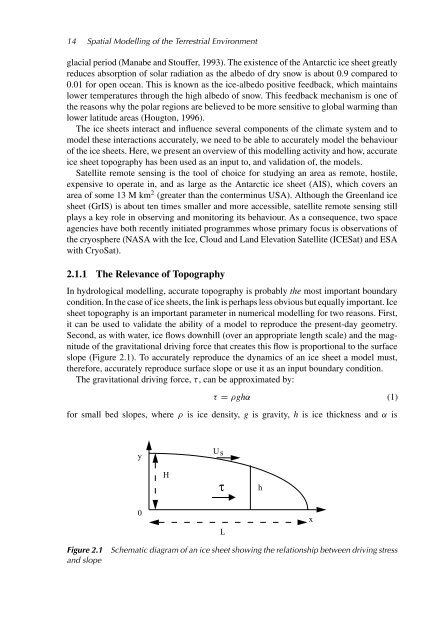
Second, as with water, ice flows downhill (over an appropriate length scale) and <strong>the</strong> magnitude<br />
<strong>of</strong> <strong>the</strong> gravitational driving force that creates this flow is proportional to <strong>the</strong> surface<br />
slope (Figure 2.1). To accurately reproduce <strong>the</strong> dynamics <strong>of</strong> an ice sheet a model must,<br />
<strong>the</strong>refore, accurately reproduce surface slope or use it as an input boundary condition.<br />
The gravitational driving force, τ, can be approximated by:<br />
τ = ρghα (1)<br />
for small bed slopes, where ρ is ice density, g is gravity, h is ice thickness and α is<br />
y<br />
Us<br />
H<br />
τ<br />
h<br />
0<br />
L<br />
x<br />
Figure 2.1<br />
and slope<br />
Schematic diagram <strong>of</strong> an ice sheet showing <strong>the</strong> relationship between driving stress


