- Page 1 and 2:
New Zealand’s Greenhouse Gas Inve
- Page 3 and 4:
Acknowledgements Key contributors M
- Page 5 and 6:
ewetting, are voluntary for the sec
- Page 7 and 8:
(table ES 3.1). This growth in emis
- Page 9 and 10:
Figure ES 4.3 Change in New Zealand
- Page 11 and 12:
Agriculture (chapter 5) 2013 New Ze
- Page 13 and 14:
Waste (chapter 7) The Waste sector
- Page 15 and 16:
in 1.AA.2.C Chemicals. Further deta
- Page 17 and 18:
Executive summary: References IPCC.
- Page 19 and 20:
Chapter 4: Industrial Processes and
- Page 21 and 22:
Chapter 14: Information on changes
- Page 23 and 24:
Table 5.1.1 Trends and relative con
- Page 25 and 26:
Table 6.5.1 New Zealand’s land-us
- Page 27 and 28:
Table 11.1.1 New Zealand’s emissi
- Page 29 and 30:
Figure 3.3.1 Reference and sectoral
- Page 31:
Figure 10.1.8 Effect of recalculati
- Page 34 and 35:
Convention were not enough to ensur
- Page 36 and 37:
i. New Zealand’s annual Inventory
- Page 38 and 39:
Quality control For this submission
- Page 40 and 41:
UNFCCC annual inventory review New
- Page 42 and 43:
Tier 1 methods apply IPCC default e
- Page 44 and 45:
The key categories that were identi
- Page 46 and 47:
Quantitative method used: IPPC Tier
- Page 48 and 49:
(b) IPCC Tier 1 category level asse
- Page 50 and 51:
(a) IPCC Tier 1 category trend asse
- Page 52 and 53:
(b) IPCC Tier 1 category trend asse
- Page 54 and 55:
cent from the trend uncertainty for
- Page 56 and 57:
Trading NZUs for international unit
- Page 58 and 59:
production of methanol has been spl
- Page 60 and 61:
Chapter 1: References Beets PN, Kim
- Page 62 and 63:
UNFCCC 2012a: FCCC/KP/CMP/2011/10/A
- Page 64 and 65:
population of non-dairy cattle, she
- Page 66 and 67:
Under the Climate Change Convention
- Page 68 and 69:
Table 2.2.1 New Zealand’s total (
- Page 70 and 71:
Figure 2.2.4 Change in New Zealand
- Page 72 and 73:
the forest management cap set at 3.
- Page 74 and 75:
Chapter 3: Energy 3.1 Sector overvi
- Page 76 and 77:
Table 3.1.1 Key sources of 1.A fuel
- Page 78 and 79:
improved significantly due to incre
- Page 80 and 81:
pricing information international
- Page 82 and 83:
the survey was conducted by Statist
- Page 84 and 85:
‒ Eleven landfill facilities, tot
- Page 86 and 87:
includes further information on liq
- Page 88 and 89:
Figure 3.3.4 Energy sector quality
- Page 90 and 91:
Figure 3.3.7 Carbon dioxide implied
- Page 92 and 93:
ecause the share of electricity gen
- Page 94 and 95:
Figure 3.3.9 Decision tree to ident
- Page 96 and 97:
Other - Other non-specified - Solid
- Page 98 and 99:
esult of this reallocation, and emi
- Page 100 and 101:
Figure 3.3.12 Splits used for manuf
- Page 102 and 103:
3.3.8 Fuel combustion: Transport (C
- Page 104 and 105:
Figure 3.3.13 Methane emissions fro
- Page 106 and 107:
‒ a is the slope of the line achi
- Page 108 and 109:
purpose-built natural gas (CNG) bus
- Page 110 and 111:
sufficient and robust enough to ens
- Page 112 and 113:
Residential - Liquid Fuels. Key cat
- Page 114 and 115:
Changes in emissions between 2012 a
- Page 116 and 117:
The main source of emissions from t
- Page 118 and 119:
emissions factor (UEF) in place of
- Page 120 and 121:
2000) has an emissions factor that
- Page 122 and 123:
Chapter 3: References Australian Bu
- Page 124 and 125:
Chapter 4: Industrial Processes and
- Page 126 and 127:
Figure 4.1.1 New Zealand’s annual
- Page 128 and 129:
For PFCs in Aluminium production, a
- Page 130 and 131:
In 2013, the Mineral industry categ
- Page 132 and 133:
4.2.3 Uncertainties and time-series
- Page 134 and 135:
Emissions of CO 2 from hydrogen pro
- Page 136 and 137:
use of coal as a reducing agent and
- Page 138 and 139:
Perfluorocarbon emissions (t CO 2 -
- Page 140 and 141:
factors for the Iron and steel prod
- Page 142 and 143:
Table 4.7.1 New Zealand’s halocar
- Page 144 and 145:
commercial equipment is pre-charged
- Page 146 and 147:
agency. The weighted average quanti
- Page 148 and 149:
IPCC, 2000, Tier 1 approach was use
- Page 150 and 151:
Food and drink Emissions of NMVOCs
- Page 152 and 153:
Chapter 5: Agricu ulture 5.1 Sector
- Page 154 and 155:
emissions from manure management co
- Page 156 and 157:
population and the reduction in non
- Page 158 and 159:
performed on a monthly basis. The e
- Page 160 and 161:
egional council boundaries changed.
- Page 162 and 163:
onwards for six livestock improveme
- Page 164 and 165:
The populations of goats, horses an
- Page 166 and 167:
Figure 5.1.6: Agriculture sectoral
- Page 168 and 169:
non-urea synthetic fertiliser using
- Page 170 and 171:
leaders to follow, including the de
- Page 172 and 173:
The model has been updated to inclu
- Page 174 and 175:
Table 5.2.1 Trends and relative con
- Page 176 and 177:
Table 5.2.3 New Zealand’s implied
- Page 178 and 179:
grass-legume pasture, the predomina
- Page 180 and 181:
5.2.6 Source-specific planned impro
- Page 182 and 183:
Table 5.3.2 Distribution of livesto
- Page 184 and 185:
obtained from all New Zealand studi
- Page 186 and 187:
Nitrogen excretion rates for the mi
- Page 188 and 189:
Indirect nitrous oxide from manure
- Page 190 and 191:
the Enteric fermentation section, t
- Page 192 and 193:
(evaporation or sublimation) and su
- Page 194 and 195:
ivers, lakes and estuaries (Clough
- Page 196 and 197:
EF 1(UREA) = proportion of direct N
- Page 198 and 199:
MS T is the proportion of manure ex
- Page 200 and 201:
44 28 44 28 ∙ Where: AG
- Page 202 and 203:
with a peaty layer are included in
- Page 204 and 205:
Frac LEACH-H is the fraction of N a
- Page 206 and 207:
Nitrification inhibitor dicyandiami
- Page 208 and 209:
EF 3(PR&P) has the most influence o
- Page 210 and 211:
However, the authors concluded that
- Page 212 and 213:
5.7.2 Methodological issues The emi
- Page 214 and 215:
5.7.6 Source-specific planned impro
- Page 216 and 217:
5.8.7 Source-specific planned impro
- Page 218 and 219:
Chapter 5: References Some referenc
- Page 220 and 221:
Kelliher FM, Cox N, van der Weerden
- Page 222 and 223:
Thomas S, Wallace D, Beare M. 2014.
- Page 224 and 225:
2012-2013 Between 2012 and 2013, ne
- Page 226 and 227:
New Zealand’s exotic forest plant
- Page 228 and 229:
Table 6.1.4 New Zealand’s emissio
- Page 230 and 231:
Calculation of national emission es
- Page 232 and 233:
Further details on the emission fac
- Page 234 and 235:
land-use areas as at 1 January 1990
- Page 236 and 237:
Land-use subcategory Low producing
- Page 238 and 239:
The potential woody change layers w
- Page 240 and 241:
Figure 6.2.3 Land-use map of New Ze
- Page 242 and 243:
Figure 6.2.4 Identification of post
- Page 244 and 245:
no change: The area has not been de
- Page 246 and 247:
Figure 6.2.6 Land-use map of New Ze
- Page 248 and 249:
Prominent land-use changes between
- Page 250 and 251:
Table 6.2.6 New Zealand’s land-us
- Page 252 and 253:
6.2.4 Methodological change The 201
- Page 254 and 255:
had been detected at the 95 per cen
- Page 256 and 257:
In equation (4), , is the mean so
- Page 258 and 259:
767 samples and the smallest (Other
- Page 260 and 261:
significantly different from the re
- Page 262 and 263:
layer of the Land Environments New
- Page 264 and 265:
(Baisden et al, 2006a, 2006b). This
- Page 266 and 267:
Table 6.4.3 New Zealand’s net car
- Page 268 and 269:
Figure 6.4.2 New Zealand’s net ca
- Page 270 and 271:
Soil carbon changes associated with
- Page 272 and 273:
Figure 6.4.4 Location of New Zealan
- Page 274 and 275:
egenerating forest was driven prima
- Page 276 and 277:
The stand tending model: New Zealan
- Page 278 and 279:
Non-CO 2 emissions for pre-1990 pla
- Page 280 and 281:
(Stephens et al, 2012). In practice
- Page 282 and 283:
period is 2.2 tonnes C ha -1 yr -1
- Page 284 and 285:
Table 6.4.8 Uncertainty in New Zeal
- Page 286 and 287:
measured (Beets et al, 2011a, 2012a
- Page 288 and 289:
Mapping of forest areas will be ite
- Page 290 and 291:
section 6.2. Emissions and removals
- Page 292 and 293:
conversion (GPG-AFOLU, table 5.9, I
- Page 294 and 295:
6.5.6 Category-specific planned imp
- Page 296 and 297:
more information on deforestation,
- Page 298 and 299:
matter prior to conversion is lost)
- Page 300 and 301:
The majority of New Zealand’s hyd
- Page 302 and 303:
Soil carbon Soil carbon stocks in L
- Page 304 and 305:
Table 6.8.2 New Zealand’s carbon
- Page 306 and 307:
An analysis of change in area shows
- Page 308 and 309:
new activity data from the improved
- Page 310 and 311:
6.10.3 Uncertainties and time-serie
- Page 312 and 313:
Uncertainties and time-series consi
- Page 314 and 315:
with the clearing of vegetation pri
- Page 316 and 317:
Chapter 6: References Ausseil A, Ja
- Page 318 and 319:
Contract report prepared for the Mi
- Page 320 and 321:
www.mfe.govt.nz/publications/climat
- Page 322 and 323:
Wakelin SJ, Beets PN. 2013. Emissio
- Page 324 and 325:
Table 7.1.1 New Zealand’s greenho
- Page 326 and 327:
municipal solid waste activity data
- Page 328 and 329:
Table 7.2.1 Landfill emissions in C
- Page 330 and 331:
Methane correction factor and oxida
- Page 332 and 333:
which have been filled by correlati
- Page 334 and 335:
7.2.6 Source-specific planned impro
- Page 336 and 337:
7.4.4 Source-specific QA/QC and ver
- Page 338 and 339:
production, and consequently the ne
- Page 340 and 341:
Summary of parameters used Table 7.
- Page 342 and 343:
Table 7.5.5 Parameter values applie
- Page 344 and 345:
Table 7.5.7 Parameter values applie
- Page 346 and 347:
Chapter 7: References Beca Infrastr
- Page 348 and 349:
Chapter 9: Indirect carbon dioxide
- Page 350 and 351:
Figure 10.1.1 Effect of recalculati
- Page 352 and 353:
Figure 10.1.4 Effect of change to o
- Page 354 and 355:
10.1.3 Agriculture Improvements mad
- Page 356 and 357:
10.1.4 Land use, land-use change an
- Page 358 and 359:
Table 10.1.5 Explanations and justi
- Page 360 and 361:
Table 10.1.8 Recalculations to New
- Page 362 and 363:
Sector CH 4 Energy - Navigation: li
- Page 364 and 365:
Chapter 11: KP-LULUCF 11.1 General
- Page 366 and 367:
Table 11.1.2 New Zealand’s emissi
- Page 368 and 369:
and Forestry, 2002). The two estate
- Page 370 and 371:
The Erosion Control Funding Program
- Page 372 and 373:
2009a). This led to a significant r
- Page 374 and 375:
Transitions to deforestation are ba
- Page 376 and 377:
Harvest of afforestation and refore
- Page 378 and 379:
is assumed that the carbon stock af
- Page 380 and 381:
gross:net accounting for afforestat
- Page 382 and 383:
Table 11.3.2 Recalculations to New
- Page 384 and 385:
period, whichever is later. In prac
- Page 386 and 387:
Figure 11.4.1 Verification of defor
- Page 388 and 389:
Recommends that, in case New Zealan
- Page 390 and 391:
Ministry of Agriculture and Forestr
- Page 392 and 393:
12.2 Summary of the standard electr
- Page 394 and 395:
Table 12.2.2 Copies of the 2014 fir
- Page 396 and 397:
Party NZ Submission Year 2015 Repor
- Page 398 and 399:
Party NZ Submission Year 2015 Repor
- Page 400 and 401:
Table 6 a. Memo item: corrective tr
- Page 402 and 403:
Party NZ Submission Year 2015 Repor
- Page 404 and 405:
Table 3. Expiry, cancellation and r
- Page 406 and 407:
Table 5 a. Summary information on a
- Page 408 and 409:
Party NZ Submission Year 2015 Repor
- Page 410 and 411: Table 12.2.4 Copies of the 2014 sec
- Page 412 and 413: Party NZ Submission Year 2015 Repor
- Page 414 and 415: Party NZ Submission Year 2015 Repor
- Page 416 and 417: Table 5 (c). Summary information on
- Page 418 and 419: Table 6 a. Memo item: corrective tr
- Page 420 and 421: Type of information to be made publ
- Page 422 and 423: Type of information to be made publ
- Page 424 and 425: 12.5 Calculation of the commitment
- Page 426 and 427: Chapter 13: Information on changes
- Page 428 and 429: several earthquakes of 6.5-6.9 magn
- Page 430 and 431: Section subheading measures 15/CMP.
- Page 432 and 433: the issues related to the implement
- Page 434 and 435: A further example is New Zealand’
- Page 436 and 437: 4.2 of the IPCC 2006 Guidelines (IP
- Page 438 and 439: IPCC Tier 1 category level assessme
- Page 440 and 441: IPCC Tier 1 category level assessme
- Page 442 and 443: IPCC Tier 1 category trend assessme
- Page 444 and 445: IPCC Tier 1 category trend assessme
- Page 446 and 447: Annex 2: Uncertainty analysis (tabl
- Page 448 and 449: Table A2.1.1 The uncertainty calcul
- Page 450 and 451: Table A2.1.2 The uncertainty calcul
- Page 452 and 453: Annex 3.1: Detailed methodological
- Page 454 and 455: Livestock category Non-dairy (beef)
- Page 456 and 457: Table A3.1.2.3 Emission factors for
- Page 458 and 459: Table A3.2.1 Uncertainty analysis f
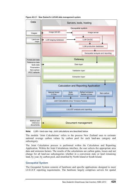
- Page 462 and 463: database storage, management, versi
- Page 464 and 465: Versioning at a number of levels en
- Page 466 and 467: Annex 3: References Some references
- Page 468 and 469: Annex 4: Methodology and data colle
- Page 470 and 471: Table A4.2 Consumption-weighted ave
- Page 472 and 473: Table A4.4 Nitrous oxide emission f
- Page 474 and 475: Table A4.6 Carbon content (per cent
- Page 476 and 477: Diesel N 2 O emission factors (mg/k
- Page 478 and 479: 446 New Zealand’s Greenhouse Gas
- Page 480 and 481: Figure A4.2 New Zealand oil energy
- Page 482: Annex 5: Additional material All su