- Page 1 and 2:
CIVIL AIR PATROLU.S. Air Force Auxi
- Page 3 and 4:
AcknowledgementsMany dedicated pers
- Page 5 and 6:
Suppose you want to conduct a Missi
- Page 7 and 8:
Mission Pilot Course Classroom Sche
- Page 9 and 10:
Table of ContentsList of Acronyms _
- Page 11 and 12:
9. Mission Pilot __________________
- Page 13 and 14:
List of AcronymsA/C AircraftA/P Air
- Page 15 and 16:
SARSARSATSQTRSOSUATPATFRTWEBUSAFUTC
- Page 17 and 18:
Chapter1. Mission Observer Duties1O
- Page 19 and 20:
Once airborne, the observer provide
- Page 21 and 22:
Chapter2. Communications2Airmen use
- Page 23 and 24:
The 720-channel radios are normally
- Page 25 and 26:
adio but failed to select the corre
- Page 27 and 28:
Intercom Mode. A 3-position toggle
- Page 29 and 30:
Controls and normal settings:• Th
- Page 31 and 32:
go. The pilot may repeat this maneu
- Page 33 and 34:
Keeping contact with the ground tea
- Page 35 and 36:
Objective is here.SAR• Aircraft a
- Page 37 and 38:
and are updated as changes occur. T
- Page 39 and 40:
2.3.6 Hazardous In-Flight Weather A
- Page 41 and 42:
Chapter3. Weather3OBJECTIVES:1. Dis
- Page 43 and 44:
This theoretical pattern, however,
- Page 45 and 46:
the mountainside. The stronger the
- Page 47 and 48:
typical C172 significantly increase
- Page 49 and 50:
or visible moisture with temperatur
- Page 51 and 52:
If a flight were made from Pittsbur
- Page 53 and 54:
• Make an immediate landing that
- Page 55 and 56:
thorough weather briefing before fl
- Page 57 and 58:
measurements of the height of the f
- Page 59 and 60:
Chapter4. High Altitude and Terrain
- Page 61 and 62:
Assume an aircraft is taking off fr
- Page 63 and 64:
Density altitude’s effect on twin
- Page 65 and 66:
4.3.2 Sinus blockDuring ascent and
- Page 67 and 68:
Chapter5. Navigation and PositionDe
- Page 69 and 70:
ecause most ground or surface dista
- Page 71 and 72:
5.3 Magnetic variationVariation is
- Page 73 and 74:
Figure 8-3Warning Areas are similar
- Page 75 and 76:
5.5 Electronic Aids to Navigation (
- Page 77 and 78:
Figure 5-6In a crosswind, the pilot
- Page 79 and 80:
To fly away from a station, first t
- Page 81 and 82:
displayed, typically in miles and t
- Page 83 and 84:
Fly between any two pointsThe abili
- Page 85 and 86:
and maintain current charts. It lis
- Page 87 and 88:
careful study of contour lines. An
- Page 89 and 90:
wires exist between the strobe-equi
- Page 91 and 92: Next you must determine the total d
- Page 93 and 94: departure and destination. Your tru
- Page 95 and 96: 37-00NAB30'CD103-00W36-00N30'102-00
- Page 97 and 98: 40-00N40-00N30'39-00N39-00N30'90-00
- Page 99 and 100: Chapter6. Search Planning and Cover
- Page 101 and 102: 6.2 Search PlanningWhen faced with
- Page 103 and 104: • Pilot's previous flying record.
- Page 105 and 106: Per CAPR 60-1, sustained flight bel
- Page 107 and 108: earlier example of the missing red
- Page 109 and 110: ground units is the primary individ
- Page 111 and 112: air can change rapidly and the emer
- Page 113 and 114: At each site, besides sketching or
- Page 115 and 116: Chapter7. Electronic Search Pattern
- Page 117 and 118: activation (e.g., removal/installat
- Page 119 and 120: Track of missing aircraftB½ x S½
- Page 121 and 122: Functional Check - with transmitter
- Page 123 and 124: your heading for a few minutes. The
- Page 125 and 126: Figure 7-4Figure 7-5Upon hearing th
- Page 127 and 128: eturn to the position and altitude
- Page 129 and 130: the signal strength measures 8.0) a
- Page 131 and 132: Figure 7-9The crew receives the bri
- Page 133 and 134: Figure 7-10aOnce you have determine
- Page 135 and 136: 7.10.1 Legal IssuesPer CAPR 60-3 Ch
- Page 137 and 138: Chapter8. Visual Search Patterns8Al
- Page 139 and 140: 8.2 Track line (route) searchThe pl
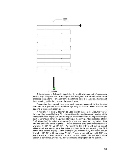
- Page 141: starting at the entry point (northe
- Page 145 and 146: Assume that the aircraft will be fl
- Page 147 and 148: Figure 8-5The GPS is used because t
- Page 149 and 150: • Starting Waypoint (483´ AGL to
- Page 151 and 152: method of keeping records during co
- Page 153 and 154: Chapter9. Mission Pilot9OBJECTIVES:
- Page 155 and 156: 9.2.1 Flying Into and Taxiing on Un
- Page 157 and 158: about fuel status at least once an
- Page 159 and 160: • Per CAPR 60-1, simulated emerge
- Page 161 and 162: constant-rate turns under IFR condi
- Page 163 and 164: The great majority of our imaging m
- Page 165 and 166: Bird’s Eye Imaging PatternFigure
- Page 167 and 168: • Search patterns using the GPS a
- Page 169 and 170: • If equipped with a transponder,
- Page 171 and 172: of the discrepancies make the aircr
- Page 173 and 174: • Cargo tie-down or cargo net (pr
- Page 175 and 176: single-engine aircraft, 100' behind
- Page 177 and 178: Review search assignments and doubl
- Page 179 and 180: available). [Note: Tie-down chains
- Page 181 and 182: Like the rest of the aircrew, the m
- Page 183 and 184: Chapter10. Step Through a Typical M
- Page 185 and 186: 10.1 Leaving Home Base for Mission
- Page 187 and 188: Also fill out your "Inbound" CAPF 1
- Page 189 and 190: Keep the emergency checklist close
- Page 191 and 192: the decision maker the greatest opp
- Page 193 and 194:
about aircraft markings and perform
- Page 195 and 196:
Figure 10-2b195
- Page 197 and 198:
the pilot to the Flight Release Off
- Page 199 and 200:
10.10 Debriefing InformationThe Deb
- Page 201 and 202:
assessment into consideration when
- Page 203 and 204:
Finally, the crew should brief thei
- Page 205 and 206:
Chapter11. Crew Resource Management
- Page 207 and 208:
11.2 Failures and the Error ChainFa
- Page 209 and 210:
Once we have lost situational aware
- Page 211 and 212:
11.7 Identification of ResourcesExt
- Page 213 and 214:
AttachmentAttachment 1AGRIDDINGAppe
- Page 215 and 216:
Attachment 2FLIGHT GUIDEThe Flight
- Page 217 and 218:
31. Formsa. ELT Search Information
- Page 219 and 220:
IndexAaccident chain · 181ADF · 3
- Page 221 and 222:
Imaging · 162Imaging flight patter
- Page 223:
Visual Routes (VR) · 73VOR · 37,