

botswana/namibia - Cour international de Justice
botswana/namibia - Cour international de Justice
botswana/namibia - Cour international de Justice

You also want an ePaper? Increase the reach of your titles
YUMPU automatically turns print PDFs into web optimized ePapers that Google loves.
the River Rovuma in Article I(2) and to the River Aka in Article IV (i) of the 1890<br />
Agreement.<br />
272. The northern channel in the vicinity of Kasikili/Sedudu Island satisfies the treaty makers'<br />
requirement of a 'main channel' through which the Chobe River '<strong>de</strong>scends' to its confluence<br />
with the Zambezi. Flow through the northern channel is continuous in a downstream direction<br />
with a constant level of 925.6 metres, South African Mean Sea Level, measured at the Kasane<br />
Gauging Station through all seasons of the year. (Mean monthly water levels at the Kasane<br />
Gauging Station are shown on Table 3 in Professor Sefe's Second Opinion, pp.28-35 (in<br />
Appendix 2 of this Counter-Memorial).<br />
273. This flow is <strong>de</strong>monstrated in the hydrological surveys and gaugings carried out by the<br />
Department of Water Affairs (Botswana) at seven stations along the Kwando-Linyanti-Chobe<br />
system south of the Caprivi Strip from the Upper Kwando down to Shaile, as shown on the<br />
Map D opposite page 13 of this Counter-Memorial.<br />
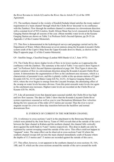
G9 - Satellite Image, Classified Image (Landsat MSS Bands 4,5,6,7, June 1975)<br />
274. The Chobe River shows higher levels of flow in its lower reaches as it approaches the<br />
confluence with the Zambezi. The summary at the end of Table 3 was used to draw Figures 6<br />
and 7 in Professor Sefe's Second Opinion reproduced at page 104. This Figure 6 shows the<br />
spatial variation of flow in a downstream direction along the Kwando-Linyanti-Chobe River<br />
system. It <strong>de</strong>monstrates the augmentation of flow as the catchment area increases, which is a<br />
characteristic of perennial rivers, and this is plainly visible at the up-stream stations of Upper<br />
Kwando (GS No. 6115) and Bates Camp (GS No. 6125). At Sajawa Gauging Station No.<br />
6414, where the river begins to emerge from the Linyanti Swamps, the attenuating effect of<br />
the swamp on water levels becomes obvious. From this point onwards water levels rise again<br />
as the catchment area increases. Highest water levels are recor<strong>de</strong>d on the Chobe River at<br />
Kasane (GS No. 6624).<br />
275. Like all perennial rivers that <strong>de</strong>pend upon seasonal rainfall, the Chobe River has high<br />
and low flow seasons. The data in Table 3 show that the Kwando-Linyanti-Chobe River<br />
system experiences seasonal as well as year to year fluctuations.Minimum flow velocities<br />
during the low season are of the or<strong>de</strong>r of 0.5 metres per second. Thus the river is never<br />
stagnant except for a two or three-day transition between the backflow and normal<br />
downstream flow.<br />
II. EVIDENCE OF CURRENT IN THE NORTHERN CHANNEL<br />
276. A reference to cross-sections 5 and 6 in the attachment to the Botswana Memorial<br />
(which were plotted by the Joint Survey Team of 1985) reveals that at the outsi<strong>de</strong> of the curve<br />
between the Spur channel at Kabuta and the northern channel, the channel falls vertically<br />
down against the north bank to 9 and 7 metres respectively. This drop in <strong>de</strong>pth can only be<br />
explained by current sweeping round the outsi<strong>de</strong> of the curve. This effect could not happen in<br />
"stagnant" water. The same effect can be observed at cross-sections 9 and 10 where the<br />
southern channel sweeps left out into the main channel immediately south of Kasane where<br />
the <strong>de</strong>pths of 13.5 metres and 7.5 metres are recor<strong>de</strong>d against the outsi<strong>de</strong> of this curve.<br />
277. This effect, however, is not apparent in the southern channel at cross-sections 18, 18A,<br />
18B, and 19, which are the cross-sections around the outsi<strong>de</strong> of the curve around the north


