

botswana/namibia - Cour international de Justice
botswana/namibia - Cour international de Justice
botswana/namibia - Cour international de Justice

You also want an ePaper? Increase the reach of your titles
YUMPU automatically turns print PDFs into web optimized ePapers that Google loves.
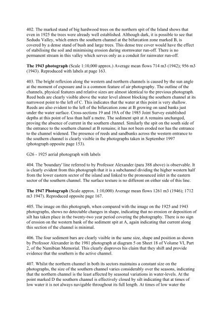
402. The marked stand of big hardwood trees on the northern spit of the Island shows that<br />
even in 1925 the trees were already well established. Although dark, it is possible to see that<br />
Sedudu Valley, which enters the southern channel at the bifurcation zone marked B, is<br />
covered by a <strong>de</strong>nse stand of bush and large trees. This <strong>de</strong>nse tree cover would have the effect<br />
of stabilising the soil and minimising erosion during stormwater run-off. There is no<br />
permanent stream in this valley which serves only as a conduit for rainwater run-off.<br />
The 1943 photograph (Scale 1:10,000 approx.) Average mean flows 714 m3 (1942); 956 m3<br />
(1943). Reproduced with labels at page 163.<br />
403. The bright reflexion along the western and northern channels is caused by the sun angle<br />
at the moment of exposure and is a common feature of air photography. The outline of the<br />
channels, physical features and relative sizes are almost i<strong>de</strong>ntical to the previous photograph.<br />
Reed beds are clearly visible above the water level almost blocking the southern channel at its<br />
narrowest point to the left of C. This indicates that the water at this point is very shallow.<br />
Reeds are also evi<strong>de</strong>nt to the left of the bifurcation zone at B growing on sand banks just<br />
un<strong>de</strong>r the water surface. Cross-sections 19 and 19A of the 1985 Joint Survey established<br />
<strong>de</strong>pths at this point of less than half a metre. The sediment spit at A remains unchanged,<br />
proving the absence of current in the southern channel. Similarly the spit on the south si<strong>de</strong> of<br />
the entrance to the southern channel at B remains; it has not been ero<strong>de</strong>d nor has the entrance<br />
to the channel wi<strong>de</strong>ned. The presence of reeds and sandbanks across the western entrance to<br />
the southern channel is clearly visible in the photographs taken in September 1997<br />
(photograph opposite page 153).<br />
G26 - 1925 aerial photograph with labels<br />
404. The 'boundary' line referred to by Professor Alexan<strong>de</strong>r (para 388 above) is observable. It<br />
is clearly evi<strong>de</strong>nt from this photograph that it is a subchannel dividing the higher western half<br />
from the lower eastern sector of the island and linked to the pronounced inlet in the eastern<br />
sector of the southern channel. The surface texture is no different on either si<strong>de</strong> of this line.<br />
The 1947 Photograph (Scale approx. 1:10,000) Average mean flows 1261 m3 (1946); 1712<br />
m3 1947). Reproduced opposite page 167.<br />
405. The image on this photograph, when compared with the image on the 1925 and 1943<br />
photographs, shows no <strong>de</strong>tectable changes in shape, indicating that no erosion or <strong>de</strong>position of<br />
silt has taken place in the twenty-two year period covering the photography. There is no sign<br />
of erosion on the western bank of the sediment spit at A, again indicating that current along<br />
this section of the channel is minimal.<br />
406. The four sediment bars are clearly visible in the same size, shape and position as shown<br />
by Professor Alexan<strong>de</strong>r in the 1981 photograph at diagram 5 on Sheet 18 of Volume VI, Part<br />
2, of the Namibian Memorial. This clearly disproves his claim that they shift and provi<strong>de</strong><br />
evi<strong>de</strong>nce that the southern is the active channel.<br />
407. Whilst the northern channel in both its sectors maintains a constant size on the<br />
photographs, the size of the southern channel varies consi<strong>de</strong>rably over the seasons, indicating<br />
that the northern channel is the least affected by seasonal variations in water-levels. At the<br />
point marked D the southern channel is effectively closed by silt indicating that at times of<br />
low water it is not always navigable throughout its full length. At times of low water the


