Annual Report 2008-2009 - Department of Transport
Annual Report 2008-2009 - Department of Transport
Annual Report 2008-2009 - Department of Transport

Create successful ePaper yourself
Turn your PDF publications into a flip-book with our unique Google optimized e-Paper software.
44<br />
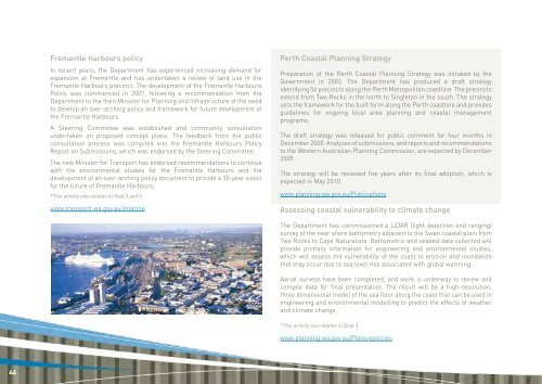
Fremantle Harbours policy<br />
In recent years, the <strong>Department</strong> has experienced increasing demand for<br />
expansion at Fremantle and has undertaken a review <strong>of</strong> land use in the<br />
Fremantle Harbours precinct. The development <strong>of</strong> the Fremantle Harbours<br />
Policy was commenced in 2007, following a recommendation from the<br />
<strong>Department</strong> to the then Minister for Planning and Infrastructure <strong>of</strong> the need<br />
to develop an over-arching policy and framework for future development at<br />
the Fremantle Harbours.<br />
A Steering Committee was established and community consultation<br />
undertaken on proposed concept plans. The feedback from the public<br />
consultation process was compiled into the Fremantle Harbours Policy<br />
<strong>Report</strong> on Submissions, which was endorsed by the Steering Committee.<br />
The new Minister for <strong>Transport</strong> has endorsed recommendations to continue<br />
with the environmental studies for the Fremantle Harbours and the<br />
development <strong>of</strong> an over-arching policy document to provide a 30-year vision<br />
for the future <strong>of</strong> Fremantle Harbours.<br />
*This activity also relates to Goal 3 and 5.<br />
www.transport.wa.gov.au/imarine<br />
Perth Coastal Planning Strategy<br />
Preparation <strong>of</strong> the Perth Coastal Planning Strategy was initiated by the<br />
Government in 2003. The <strong>Department</strong> has produced a draft strategy<br />
identifying 56 precincts along the Perth Metropolitan coastline. The precincts<br />
extend from Two Rocks in the north to Singleton in the south. The strategy<br />
sets the framework for the built form along the Perth coastline and provides<br />
guidelines for ongoing local area planning and coastal management<br />
programs.<br />
The draft strategy was released for public comment for four months in<br />
December <strong>2008</strong>. Analyses <strong>of</strong> submissions, and reports and recommendations<br />
to the Western Australian Planning Commission, are expected by December<br />
<strong>2009</strong>.<br />
The strategy will be reviewed five years after its final adoption, which is<br />
expected in May 2010.<br />
www.planning.wa.gov.au/Publications<br />
Assessing coastal vulnerability to climate change<br />
The <strong>Department</strong> has commissioned a LiDAR (light detection and ranging)<br />
survey <strong>of</strong> the near shore bathymetry adjacent to the Swan coastal plain from<br />
Two Rocks to Cape Naturaliste. Bathymetric and seabed data collected will<br />
provide primary information for engineering and environmental studies,<br />
which will assess the vulnerability <strong>of</strong> the coast to erosion and inundation<br />
that may occur due to sea level rise associated with global warming.<br />
Aerial surveys have been completed, and work is underway to review and<br />
compile data for final presentation. The result will be a high-resolution,<br />
three dimensional model <strong>of</strong> the sea floor along the coast that can be used in<br />
engineering and environmental modelling to predict the effects <strong>of</strong> weather<br />
and climate change.<br />
*This activity also relates to Goal 3<br />
www.planning.wa.gov.au/Plans+policies