

UNESCO
2bj83Dq
2bj83Dq

Create successful ePaper yourself
Turn your PDF publications into a flip-book with our unique Google optimized e-Paper software.
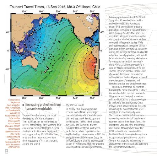
This map shows<br />
the tsunami<br />
travel times after<br />
the 8.3-magnitude<br />
earthquake which<br />
took place on<br />
16 September 2015<br />
in the shallow<br />
depths near the<br />
coast of central<br />
Chile at 22:54 GMT.<br />
The earthquake<br />
triggered activation<br />
of the Pacific<br />
Tsunami Warning<br />
and Mitigation<br />
System established<br />
under the auspices<br />
of IOC-<strong>UNESCO</strong>.<br />
98<br />
<br />
Increasing protection from<br />
tsunamis worldwide<br />
Tsunamis can be among the most<br />
devastating of natural disasters.<br />
Their damage can be minimized by<br />
precise forecasting, early warning and<br />
awareness-raising strategies. Several<br />
strategic activities were organized<br />
and supported by <strong>UNESCO</strong> this year<br />
to strengthen the protection from<br />
the devastating effects of tsunamis<br />
around the world.<br />
© ITIC<br />
The Pacific Ocean<br />
On 22 May 1960, a huge earthquake<br />
occurred south of Chile, generating a<br />
tsunami that battered the South American<br />
coast and later struck Hawaii, Japan and<br />
the Philippines. The final death toll was<br />
over 2,000. The scale of the disaster<br />
highlighted the need for an alert system<br />
for the Pacific, where 75 per cent of the<br />
world’s deadliest tsunamis occur. In 1965 the<br />
Intergovernmental Coordination Group for<br />
the Pacific Tsunami Warning and Mitigation<br />
System (PTWMS) came into being under the<br />
leadership of <strong>UNESCO</strong>’s Intergovernmental<br />
Oceanographic Commission (IOC-<strong>UNESCO</strong>).<br />
Today it has 46 Member States, and has<br />
evolved beyond issuing warnings to<br />
include work on prevention, preparing<br />
populations to respond to tsunami threats,<br />
and technology transfer. It has access to<br />
more than 150 seismic stations around the<br />
world, verifies whether a tsunami has been<br />
generated and estimates its size. While<br />
undeniably successful, the system still has<br />
gaps. Even if it can alert national authorities<br />
quickly, the message must then be relayed to<br />
vulnerable coastal populations, which could<br />
be hit minutes after an earthquake happens.<br />
To commemorate the 50th anniversary<br />
of the PTWMS, a symposium was held in<br />
April on ‘Making the Pacific Ready for the<br />
Tsunami Threat’ in Honolulu (United States<br />
of America). Participants presented the<br />
achievements of the last 50 years, reviewed<br />
the current state of the system, and<br />
identified practical and tangible next steps.<br />
In February, more than 40 countries<br />
bordering the Pacific tested their readiness<br />
in a simulated alert exercise, Pacwave15.<br />
This exercise was designed to evaluate<br />
enhanced forecasting products developed<br />
by the Pacific Tsunami Warning Centre<br />
(PTWC), which provide detailed forecasts<br />
concerning the maximal tsunami wave<br />
amplitude, its direction and power.<br />
The countries chose one of six scenarios<br />
concerning earthquakes off the shores of<br />
southern and northern Japan, Tonga, the<br />
Philippines, Chile and Peru, or Colombia<br />
and Ecuador. Messages were issued by<br />
PTWC in Ewa Beach, Hawaii and the<br />
Northwest Pacific Tsunami Advisory Centre<br />
in Japan to focal points in every country.<br />
The aim was to enable each country to<br />
assess threats with precision and determine<br />
the appropriate level of alerts.