

Planetary Geology pdf - NASA
Planetary Geology pdf - NASA
Planetary Geology pdf - NASA

Create successful ePaper yourself
Turn your PDF publications into a flip-book with our unique Google optimized e-Paper software.
done in groups or by individual students. A further<br />
suggestion for this exercise is to plot all the rover<br />
paths on a single page (or on an overhead projector<br />
viewgraph) and have the class decide on the path<br />
that is best, providing the most interesting scientific<br />
results with the least risk to the rover. Such a discussion<br />
closely simulates planning meetings for<br />
<strong>NASA</strong> missions. For further interdisciplinary application,<br />
rover groups could assign different tasks<br />
within each group: someone to draw a picture of the<br />
rover, someone to draw pictures of what the rover<br />
might see, a science group to plan the rover path, a<br />
ÒreporterÓ to write up a travelogue of what the<br />
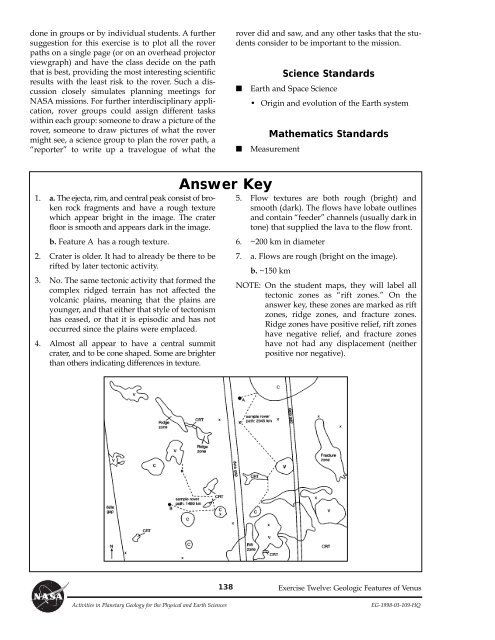
1. a. The ejecta, rim, and central peak consist of broken<br />
rock fragments and have a rough texture<br />
which appear bright in the image. The crater<br />
floor is smooth and appears dark in the image.<br />
b. Feature A has a rough texture.<br />
2. Crater is older. It had to already be there to be<br />
rifted by later tectonic activity.<br />
3. No. The same tectonic activity that formed the<br />
complex ridged terrain has not affected the<br />
volcanic plains, meaning that the plains are<br />
younger, and that either that style of tectonism<br />
has ceased, or that it is episodic and has not<br />
occurred since the plains were emplaced.<br />
4. Almost all appear to have a central summit<br />
crater, and to be cone shaped. Some are brighter<br />
than others indicating differences in texture.<br />
Answer Key<br />
138<br />
rover did and saw, and any other tasks that the students<br />
consider to be important to the mission.<br />
Science Standards<br />
■ Earth and Space Science<br />
¥ Origin and evolution of the Earth system<br />
Mathematics Standards<br />
■ Measurement<br />
5. Flow textures are both rough (bright) and<br />
smooth (dark). The flows have lobate outlines<br />
and contain ÒfeederÓ channels (usually dark in<br />
tone) that supplied the lava to the flow front.<br />
6. ~200 km in diameter<br />
7. a. Flows are rough (bright on the image).<br />
b. ~150 km<br />
NOTE: On the student maps, they will label all<br />
tectonic zones as Òrift zones.Ó On the<br />
answer key, these zones are marked as rift<br />
zones, ridge zones, and fracture zones.<br />
Ridge zones have positive relief, rift zones<br />
have negative relief, and fracture zones<br />
have not had any displacement (neither<br />
positive nor negative).<br />
Exercise Twelve: Geologic Features of Venus<br />
Activities in <strong>Planetary</strong> <strong>Geology</strong> for the Physical and Earth Sciences EG-1998-03-109-HQ


