

Planetary Geology pdf - NASA
Planetary Geology pdf - NASA
Planetary Geology pdf - NASA

You also want an ePaper? Increase the reach of your titles
YUMPU automatically turns print PDFs into web optimized ePapers that Google loves.
1. a. Sketch should show steep sides and a relatively<br />
flat top.<br />
b. The crater is roughly circular, but is irregular<br />
in detail, with multiple scallops.<br />
c. The scalloped outline reflects craters from<br />
multiple eruptions.<br />
d. Gullies have been carved down its flanks<br />
by runoff of rainfall, waves have eroded<br />
the visible base of the volcano, and the<br />
inlet has cut into volcanic material.<br />
e. The flanks have been eroded to form deep<br />
parallel gullies. The easily eroded material<br />
is unlikely to be rock but is probably ash.<br />
f. Rainfall is typically greatest on the windward<br />
side of a high-standing volcano. This<br />
is because air cools as it rises up the mountain's<br />
flanks, promoting condensation and<br />
precipitation of water. The air is relatively<br />
dry as it passes over the other side of the<br />
volcano.<br />
2. a. Wind blows from the southwest (lower<br />
right). The dunes show slip faces on their<br />
northeast sides.<br />
b. A dune in the center of the photo will<br />
migrate towards the northeast (the upper<br />
left of the photo).<br />
c. In the lower right, dunes coalesce into linear<br />
ridges (called Òtransverse dunesÓ).<br />
Crescent shaped (ÒbarchanÓ) dunes form<br />
toward the center, near a dark area blown<br />
free of dunes. Toward the upper left of the<br />
photo, dunes are U-shaped and convex the<br />
opposite way from the dunes in the lower<br />
right.<br />
d. Sand supply, consistency of wind direction,<br />
wind velocity, and the presence of vegetation<br />
all affect dune morphology.<br />
3. a. The sketch should show a tree-like ÒdendriticÓ<br />
pattern of smaller branches that join<br />
into the main trunk stream.<br />
b. South. The downhill direction is indicated<br />
by the direction small streams flow near<br />
their intersection with the larger one. A<br />
ÒYÓ pattern typically results, with the Y<br />
pointing downstream.<br />
c. Material is eroded from the rock cliffs of<br />
the waterfall and washed downstream.<br />
Gradually the cliffs will retreat in the<br />
Answer Key<br />
32<br />
upstream direction, lowering the overall<br />
topography of the region. This process is<br />
termed Òheadward erosion.Ó<br />
d. The ridge is becoming more narrow as<br />
debris is washed down the steep slopes to<br />
either side during rains. Some of this material<br />
is visible in fans near the bases of the<br />
steep slopes. Eventually the more resistant<br />
material atop the ridge will be eroded<br />
through, and the less resistant material<br />
beneath will erode away relatively rapidly.<br />
4. a. Gray. The white layers form ridges but the<br />
gray material is eroded out into valleys. In<br />
some locations, white layers have sheltered<br />
and protected the gray material from erosion.<br />
No river channels are apparent in the<br />
white material; gullies indicate that the<br />
gray material erodes easily.<br />
b. SSW c. N65W<br />
d. 35m e. 220m<br />
f. The stereo view reveals that the strata are<br />
probably not curved, but have a constant<br />
strike, and a constant dip to the southsouthwest.<br />
As the river cut downward, it<br />
exposed portions of the white layers to the<br />
south that are still buried elsewhere.<br />
Therefore, the apparent curvature in the<br />
monoscopic photo is a geometric consequence<br />
of the river having cut into the dipping<br />
strata, exposing the white layer at different<br />
elevations.<br />
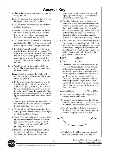
5. a. About 1200m. b. About 240m.<br />
c. Large vertical exaggeration (appears as<br />
deep or deeper than wide).<br />
d. The crater shows a raised rim that stands<br />
above the surrounding plain. The rim rises<br />
30 to 60m above the surrounding plain.<br />
e. Sketch should include bowl shape, rim-torim<br />
width of about 1200m [6cm] depth of<br />
about 200m [1cm], and raised rim.<br />
f. Similarities: Roughly round shape overall,<br />
steep and gullied interior walls, highest<br />
Exercise Three: Geologic Landforms<br />
Seen on Stereoscopic Photos<br />
Activities in <strong>Planetary</strong> <strong>Geology</strong> for the Physical and Earth Sciences EG-1998-03-109-HQ


