

Planetary Geology pdf - NASA
Planetary Geology pdf - NASA
Planetary Geology pdf - NASA

Create successful ePaper yourself
Turn your PDF publications into a flip-book with our unique Google optimized e-Paper software.
1. Answers will vary. At a minimum students<br />
should list the following: Terrain One: dark<br />
plainsÑsmooth (low relief), dark (low albedo),<br />
sparsely cratered, topographically low areas;<br />
Terrain Two: bright highlandsÑrough (high<br />
relief), light (high albedo), heavily cratered,<br />
topographically high areas. Possible additional<br />
terrains include: large young craters with<br />
rayed ejecta and moderate albedo highlands.<br />
2. Answers will vary given terrains selected. For<br />
the terrains listed in question 1, the highlands<br />
are the oldest, the smooth plains are younger,<br />
and rayed craters are the youngest. Students<br />
should see that the rayed craters are superposed<br />
(on top) of the other terrains, and that the<br />
smooth plains cover (embay) the highlands.<br />
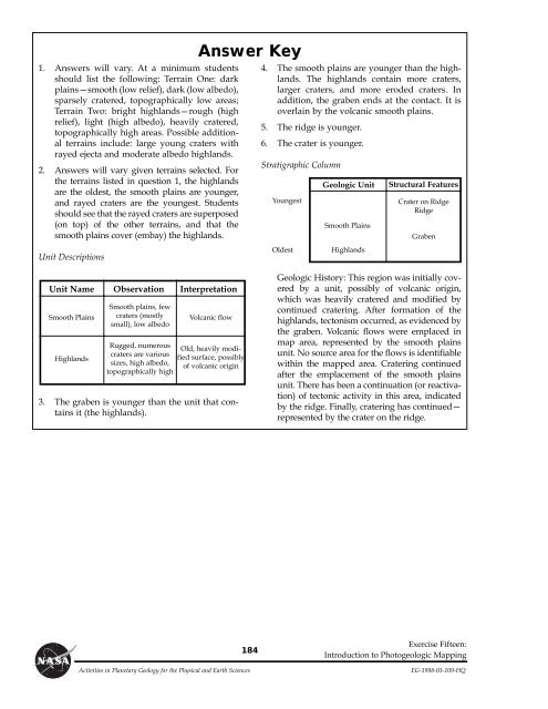
Unit Descriptions<br />
Unit Name<br />
Smooth Plains<br />
Smooth plains, few<br />
craters (mostly<br />
small), low albedo<br />
Volcanic flow<br />
Highlands<br />
Observation Interpretation<br />
Rugged, numerous<br />
craters are various<br />
sizes, high albedo,<br />
topographically high<br />
3. The graben is younger than the unit that contains<br />
it (the highlands).<br />
Answer Key<br />
Old, heavily modified<br />
surface, possibly<br />
of volcanic origin<br />
184<br />
4. The smooth plains are younger than the highlands.<br />
The highlands contain more craters,<br />
larger craters, and more eroded craters. In<br />
addition, the graben ends at the contact. It is<br />
overlain by the volcanic smooth plains.<br />
5. The ridge is younger.<br />
6. The crater is younger.<br />
Stratigraphic Column<br />
Youngest<br />
Oldest<br />
Geologic Unit Structural Features<br />
Smooth Plains<br />
Highlands<br />
Crater on Ridge<br />
Ridge<br />
Graben<br />
Geologic History: This region was initially covered<br />
by a unit, possibly of volcanic origin,<br />
which was heavily cratered and modified by<br />
continued cratering. After formation of the<br />
highlands, tectonism occurred, as evidenced by<br />
the graben. Volcanic flows were emplaced in<br />
map area, represented by the smooth plains<br />
unit. No source area for the flows is identifiable<br />
within the mapped area. Cratering continued<br />
after the emplacement of the smooth plains<br />
unit. There has been a continuation (or reactivation)<br />
of tectonic activity in this area, indicated<br />
by the ridge. Finally, cratering has continuedÑ<br />
represented by the crater on the ridge.<br />
Exercise Fifteen:<br />
Introduction to Photogeologic Mapping<br />
Activities in <strong>Planetary</strong> <strong>Geology</strong> for the Physical and Earth Sciences EG-1998-03-109-HQ


