

Planetary Geology pdf - NASA
Planetary Geology pdf - NASA
Planetary Geology pdf - NASA

Create successful ePaper yourself
Turn your PDF publications into a flip-book with our unique Google optimized e-Paper software.
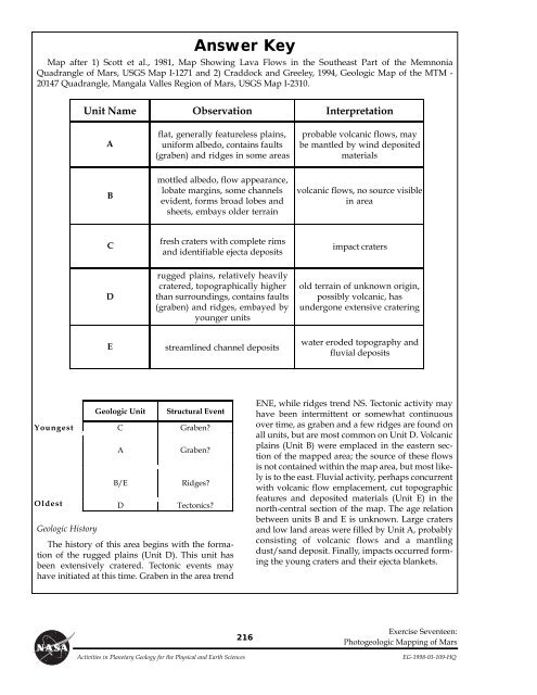
Answer Key<br />
Map after 1) Scott et al., 1981, Map Showing Lava Flows in the Southeast Part of the Memnonia<br />
Quadrangle of Mars, USGS Map I-1271 and 2) Craddock and Greeley, 1994, Geologic Map of the MTM -<br />
20147 Quadrangle, Mangala Valles Region of Mars, USGS Map I-2310.<br />
Geologic History<br />
Unit Name Observation Interpretation<br />
A<br />
B<br />
C<br />
D<br />
flat, generally featureless plains,<br />
uniform albedo, contains faults<br />
(graben) and ridges in some areas<br />
mottled albedo, flow appearance,<br />
lobate margins, some channels<br />
evident, forms broad lobes and<br />
sheets, embays older terrain<br />
fresh craters with complete rims<br />
and identifiable ejecta deposits<br />
rugged plains, relatively heavily<br />
cratered, topographically higher<br />
than surroundings, contains faults<br />
(graben) and ridges, embayed by<br />
younger units<br />
E streamlined channel deposits<br />
Geologic Unit Structural Event<br />
Youngest<br />
C Graben?<br />
A Graben?<br />
B/E Ridges?<br />
Oldest<br />
Oldest D Tectonics?<br />
The history of this area begins with the formation<br />
of the rugged plains (Unit D). This unit has<br />
been extensively cratered. Tectonic events may<br />
have initiated at this time. Graben in the area trend<br />
216<br />
probable volcanic flows, may<br />
be mantled by wind deposited<br />
materials<br />
volcanic flows, no source visible<br />
in area<br />
impact craters<br />
old terrain of unknown origin,<br />
possibly volcanic, has<br />
undergone extensive cratering<br />
water eroded topography and<br />
fluvial deposits<br />
ENE, while ridges trend NS. Tectonic activity may<br />
have been intermittent or somewhat continuous<br />
over time, as graben and a few ridges are found on<br />
all units, but are most common on Unit D. Volcanic<br />
plains (Unit B) were emplaced in the eastern section<br />
of the mapped area; the source of these flows<br />
is not contained within the map area, but most likely<br />
is to the east. Fluvial activity, perhaps concurrent<br />
with volcanic flow emplacement, cut topographic<br />
features and deposited materials (Unit E) in the<br />
north-central section of the map. The age relation<br />
between units B and E is unknown. Large craters<br />
and low land areas were filled by Unit A, probably<br />
consisting of volcanic flows and a mantling<br />
dust/sand deposit. Finally, impacts occurred forming<br />
the young craters and their ejecta blankets.<br />
Exercise Seventeen:<br />
Photogeologic Mapping of Mars<br />
Activities in <strong>Planetary</strong> <strong>Geology</strong> for the Physical and Earth Sciences EG-1998-03-109-HQ


