

Planetary Geology pdf - NASA
Planetary Geology pdf - NASA
Planetary Geology pdf - NASA

Create successful ePaper yourself
Turn your PDF publications into a flip-book with our unique Google optimized e-Paper software.
Exercise<br />
Twelve<br />
Purpose<br />
To learn about geologic features on Venus and the<br />
use of radar images.<br />
Materials<br />
Clear acetate, overhead projector markers, tape,<br />
25cm piece of string<br />
Introduction<br />
Radar is an imaging and detection system that<br />
uses the microwave section (~1mm to ~1m wavelengths)<br />
of the electromagnetic spectrum. By<br />
changing the wavelength used by radar, different<br />
objects can be detected. Radar is an active system in<br />
that the signal energy is transmitted from and<br />
received by the instrument. Our eyes are a passive<br />
system, we only receive reflected energy (as from<br />
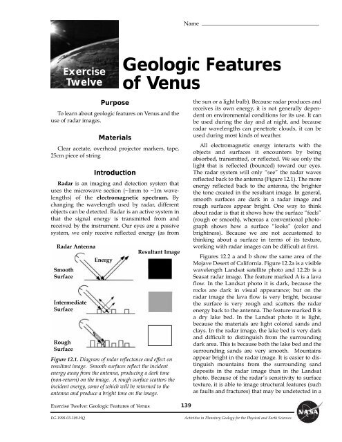
Radar Antenna<br />
Smooth<br />
Surface<br />
Intermediate<br />
Surface<br />
Rough<br />
Surface<br />
Energy<br />
Figure 12.1. Diagram of radar reflectance and effect on<br />
resultant image. Smooth surfaces reflect the incident<br />
energy away from the antenna, producing a dark tone<br />
(non-return) on the image. A rough surface scatters the<br />
incident energy, some of which will be returned to the<br />
antenna and produce a bright tone on the image.<br />
Exercise Twelve: Geologic Features of Venus<br />
Name<br />
Geologic Features<br />
of Venus<br />
Resultant Image<br />
139<br />
the sun or a light bulb). Because radar produces and<br />
receives its own energy, it is not generally dependent<br />
on environmental conditions for its use. It can<br />
be used during the day and at night, and because<br />
radar wavelengths can penetrate clouds, it can be<br />
used during most kinds of weather.<br />
All electromagnetic energy interacts with the<br />
objects and surfaces it encounters by being<br />
absorbed, transmitted, or reflected. We see only the<br />
light that is reflected (bounced) toward our eyes.<br />
The radar system will only ÒseeÓ the radar waves<br />
reflected back to the antenna (Figure 12.1). The more<br />
energy reflected back to the antenna, the brighter<br />
the tone created in the resultant image. In general,<br />
smooth surfaces are dark in a radar image and<br />
rough surfaces appear bright. One way to think<br />
about radar is that it shows how the surface ÒfeelsÓ<br />
(rough or smooth), whereas a conventional photograph<br />
shows how a surface ÒlooksÓ (color and<br />
brightness). Because we are not accustomed to<br />
thinking about a surface in terms of its texture,<br />
working with radar images can be difficult at first.<br />
Figures 12.2 a and b show the same area of the<br />
Mojave Desert of California. Figure 12.2a is a visible<br />
wavelength Landsat satellite photo and 12.2b is a<br />
Seasat radar image. The feature marked A is a lava<br />
flow. In the Landsat photo it is dark, because the<br />
rocks are dark in visual appearance; but on the<br />
radar image the lava flow is very bright, because<br />
the surface is very rough and scatters the radar<br />
energy back to the antenna. The feature marked B is<br />
a dry lake bed. In the Landsat photo it is light,<br />
because the materials are light colored sands and<br />
clays. In the radar image, the lake bed is very dark<br />
and difficult to distinguish from the surrounding<br />
dark area. This is because both the lake bed and the<br />
surrounding sands are very smooth. Mountains<br />
appear bright in the radar image. It is easier to distinguish<br />
mountains from the surrounding sand<br />
deposits in the radar image than in the Landsat<br />
photo. Because of the radarÕs sensitivity to surface<br />
texture, it is able to image structural features (such<br />
as faults and fractures) that may be undetected in a<br />
EG-1998-03-109-HQ Activities in <strong>Planetary</strong> <strong>Geology</strong> for the Physical and Earth Sciences


