

Planetary Geology pdf - NASA
Planetary Geology pdf - NASA
Planetary Geology pdf - NASA

Create successful ePaper yourself
Turn your PDF publications into a flip-book with our unique Google optimized e-Paper software.
So far all the figures have shown features that can be found on Earth as well as on Venus. Figure 12.8 shows<br />
features that may be unique to Venus. Termed ÒcoronaeÓ (the singular is ÒcoronaÓ), these features are identified<br />
by circular sets of fractures. Some form low, circular domes that can have associated volcanic flows (for<br />
example, the flows to the north and northwest of the corona marked A); or the centers may have subsided,<br />
leaving bowl-shaped depressions, which can be filled by lava flows. Radial fractures commonly surround<br />
coronae, giving a ÒbuglikeÓ appearance.<br />
6. What is the diameter of the largest corona in the image?<br />
7. a. Are the flows to the north and northwest of the corona labeled A rough or smooth in texture?<br />
Part B<br />
b. How far from the letter A did the volcanic material flow to the northwest?<br />
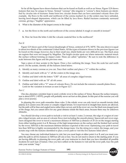
Figure 12.9 shows part of the Carson Quadrangle of Venus, centered at 11¡S, 345¡E. The area shown is equal<br />
to about two-thirds of the continental United States. All the types of features shown in the previous figures can<br />
be found on this image; however, due to their small size, shield fields are very difficult to see. The black areas<br />
are regions that were not imaged by Magellan. The bright circular spots are where meteoritic material struck<br />
the surface without forming an impact crater. These are called Òsplotches.Ó Be sure to note the difference in<br />
scale between this figure and the previous ones.<br />
Tape a piece of clear acetate to the figure. Draw a box outlining the image. Trace the scale bar and north<br />
arrow. On the acetate, identify all the features listed below.<br />
A. Identify as many coronae as you can. Trace their outline and place a ÒCÓ within the outline.<br />
B. Identify and mark with an ÒxÓ all the craters in the image area.<br />
C. Outline and label with the letters ÒCRTÓ all areas of complex ridged terrain.<br />
D. Outline and label with an ÒRÓ all rift zones.<br />
E. Outline and label with a ÒVÓ areas of volcanic flows. Do not include the extensive smooth plains flows.<br />
Look for the variation in texture as seen in Figure 12.7.<br />
Part C<br />
One day, planetary scientists hope to send a robotic rover to the surface of Venus. Because the surface temperature<br />
is about 470¡C (~870¡F), people will probably never set foot on this planet. In this part of the exercise you will<br />
plan a rover journey.<br />
In planning the rover path remember these rules: 1) the robotic rover can only travel on smooth terrain (dark<br />
plains); 2) it cannot cross rift zones or complex ridged terrain; 3) it must travel in straight lines (turns are allowed,<br />
but the path will be lines and angled turns rather than curves); and 4) the rover can cross the black non-imaged parts<br />
of the image, but you cannot drive for any great distance inside the black areas, because there may be unknown<br />
obstacles.<br />
You should develop a rover path to include a visit to at least 1 crater, 2 coronae, the edge of a region of complex<br />
ridged terrain, and an area of volcanic flows (not including the smooth plains). Spacecraft and rover engineers<br />
designed the rover to travel a maximum distance of 3430 km (a distance of 25 cm on the image) starting<br />
from either landing point A or B. Because of the high temperatures on the surface and the limited fuel carried<br />
by the rover, 3430 km is the maximum lifetime-distance expected of the rover. Optimizing your path to travel<br />
less than 3430 km is highly recommended by the design team. Use the string (or a ruler), the image, and your<br />
acetate map with the features identified to plan a rover path to visit the five features listed above.<br />
You may choose any individual feature to visit, but you must begin at either point A or B, and you must complete<br />
the path to all five features in 3430 km (25 cm) or less. You do not need to return to the starting point. If you<br />
are having difficulty in planning the rover path, ask your instructor to check that you have identified all possible<br />
locations for each type of feature. Once you have settled on the features to visit and the rover path, trace the path<br />
onto your acetate Òmap.Ó<br />
Exercise Twelve: Geologic Features of Venus<br />
141<br />
EG-1998-03-109-HQ Activities in <strong>Planetary</strong> <strong>Geology</strong> for the Physical and Earth Sciences


