Create successful ePaper yourself
Turn your PDF publications into a flip-book with our unique Google optimized e-Paper software.
E:units = "s-1" ;<br />
float SINALPHA(Time, south_north, west_east) ;<br />
SINALPHA:description = "Local sine of map rotation" ;<br />
SINALPHA:units = "" ;<br />
float COSALPHA(Time, south_north, west_east) ;<br />
COSALPHA:description = "Local cosine of map rotation" ;<br />
COSALPHA:units = "" ;<br />
float HGT(Time, south_north, west_east) ;<br />
HGT:description = "Terrain Height" ;<br />
HGT:units = "m" ;<br />
float HGT_SHAD(Time, south_north, west_east) ;<br />
HGT_SHAD:description = "Height of orographic shadow" ;<br />
HGT_SHAD:units = "m" ;<br />
float TSK(Time, south_north, west_east) ;<br />
TSK:description = "SURFACE SKIN TEMPERATURE" ;<br />
TSK:units = "K" ;<br />
float P_TOP(Time) ;<br />
P_TOP:description = "PRESSURE TOP OF THE MODEL" ;<br />
P_TOP:units = "Pa" ;<br />
float MAX_MSTFX(Time) ;<br />
MAX_MSTFX:description = "Max map factor in domain" ;<br />
MAX_MSTFX:units = "" ;<br />
float MAX_MSTFY(Time) ;<br />
MAX_MSTFY:description = "Max map factor in domain" ;<br />
MAX_MSTFY:units = "" ;<br />
float RAINC(Time, south_north, west_east) ;<br />
RAINC:description = "ACCUMULATED TOTAL CUMULUS PRECIPITATION" ;<br />
RAINC:units = "mm" ;<br />
float RAINNC(Time, south_north, west_east) ;<br />
RAINNC:description = "ACCUMULATED TOTAL GRID SCALE PRECIPITATION" ;<br />
RAINNC:units = "mm" ;<br />
float PRATEC(Time, south_north, west_east) ;<br />
PRATEC:description = "PRECIP RATE FROM CUMULUS SCHEME" ;<br />
PRATEC:units = "mm s-1" ;<br />
float RAINCV(Time, south_north, west_east) ;<br />
RAINCV:description = "TIME-STEP CUMULUS PRECIPITATION" ;<br />
RAINCV:units = "mm" ;<br />
float SNOWNC(Time, south_north, west_east) ;<br />
SNOWNC:description = "ACCUMULATED TOTAL GRID SCALE SNOW AND ICE" ;<br />
SNOWNC:units = "mm" ;<br />
float GRAUPELNC(Time, south_north, west_east) ;<br />
GRAUPELNC:description = "ACCUMULATED TOTAL GRID SCALE GRAUPEL" ;<br />
GRAUPELNC:units = "mm" ;<br />
float EDT_OUT(Time, south_north, west_east) ;<br />
EDT_OUT:description = "EDT FROM GD SCHEME" ;<br />
EDT_OUT:units = "" ;<br />
float SWDOWN(Time, south_north, west_east) ;<br />
SWDOWN:description = "DOWNWARD SHORT WAVE FLUX AT GROUND SURFACE" ;<br />
SWDOWN:units = "W m-2" ;<br />
float GLW(Time, south_north, west_east) ;<br />
GLW:description = "DOWNWARD LONG WAVE FLUX AT GROUND SURFACE" ;<br />
GLW:units = "W m-2" ;<br />
float OLR(Time, south_north, west_east) ;<br />
OLR:description = "TOA OUTGOING LONG WAVE" ;<br />
OLR:units = "W m-2" ;<br />
float XLAT(Time, south_north, west_east) ;<br />
XLAT:description = "LATITUDE, SOUTH IS NEGATIVE" ;<br />
XLAT:units = "degree_north" ;<br />
float XLONG(Time, south_north, west_east) ;<br />
XLONG:description = "LONGITUDE, WEST IS NEGATIVE" ;<br />
XLONG:units = "degree_east" ;<br />
float XLAT_U(Time, south_north, west_east_stag) ;<br />
XLAT_U:description = "LATITUDE, SOUTH IS NEGATIVE" ;<br />
XLAT_U:units = "degree_north" ;<br />
float XLONG_U(Time, south_north, west_east_stag) ;<br />
XLONG_U:description = "LONGITUDE, WEST IS NEGATIVE" ;<br />
XLONG_U:units = "degree_east" ;<br />
float XLAT_V(Time, south_north_stag, west_east) ;<br />
XLAT_V:description = "LATITUDE, SOUTH IS NEGATIVE" ;<br />
XLAT_V:units = "degree_north" ;<br />
float XLONG_V(Time, south_north_stag, west_east) ;<br />
XLONG_V:description = "LONGITUDE, WEST IS NEGATIVE" ;<br />
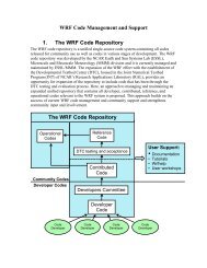
MODEL<br />
<strong>WRF</strong>-<strong>ARW</strong> V3: User’s <strong>Guide</strong> 5-57