Create successful ePaper yourself
Turn your PDF publications into a flip-book with our unique Google optimized e-Paper software.
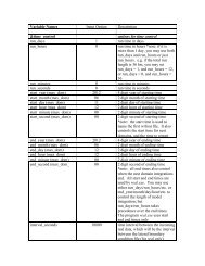
WPS<br />
! 0 = cylindrical equidistant<br />
! 1 = Mercator<br />
! 3 = Lambert conformal conic<br />
! 4 = Gaussian (global only!)<br />
! 5 = Polar stereographic<br />
real :: nlats ! Number of latitudes north of equator<br />
! (for Gaussian grids)<br />
real :: xfcst ! Forecast hour of data<br />
real :: xlvl ! Vertical level of data in 2-d array<br />
real :: startlat, startlon ! Lat/lon of point in array indicated by<br />
! startloc string<br />
real :: deltalat, deltalon ! Grid spacing, degrees<br />
real :: dx, dy ! Grid spacing, km<br />
real :: xlonc ! Standard longitude of projection<br />
real :: truelat1, truelat2 ! True latitudes of projection<br />
real :: earth_radius ! Earth radius, km<br />
real, dimension(nx,ny) :: slab ! The 2-d array holding the data<br />
logical :: is_wind_grid_rel ! Flag indicating whether winds are<br />
! relative to source grid (TRUE) or<br />
! relative to earth (FALSE)<br />
character (len=8) :: startloc ! Which point in array is given by<br />
! startlat/startlon; set either<br />
! to 'SWCORNER' or 'CENTER '<br />
character (len=9) :: field ! Name of the field<br />
character (len=24) :: hdate ! Valid date for data YYYY:MM:DD_HH:00:00<br />
character (len=25) :: units ! Units of data<br />
character (len=32) :: map_source ! Source model / originating center<br />
character (len=46) :: desc ! Short description of data<br />
! 1) WRITE FORMAT VERSION<br />
write(unit=ounit) version<br />
! 2) WRITE METADATA<br />
! Cylindrical equidistant<br />
if (iproj == 0) then<br />
write(unit=ounit) hdate, xfcst, map_source, field, &<br />
units, desc, xlvl, nx, ny, iproj<br />
write(unit=ounit) startloc, startlat, startlon, &<br />
deltalat, deltalon, earth_radius<br />
! Mercator<br />
else if (iproj == 1) then<br />
write(unit=ounit) hdate, xfcst, map_source, field, &<br />
units, desc, xlvl, nx, ny, iproj<br />
write(unit=ounit) startloc, startlat, startlon, dx, dy, &<br />
truelat1, earth_radius<br />
! Lambert conformal<br />
else if (iproj == 3) then<br />
write(unit=ounit) hdate, xfcst, map_source, field, &<br />
units, desc, xlvl, nx, ny, iproj<br />
write(unit=ounit) startloc, startlat, startlon, dx, dy, &<br />
xlonc, truelat1, truelat2, earth_radius<br />
! Gaussian<br />
else if (iproj == 4) then<br />
write(unit=ounit) hdate, xfcst, map_source, field, &<br />
units, desc, xlvl, nx, ny, iproj<br />
write(unit=ounit) startloc, startlat, startlon, &<br />
nlats, deltalon, earth_radius<br />
! Polar stereographic<br />
else if (iproj == 5) then<br />
<strong>WRF</strong>-<strong>ARW</strong> V3: User’s <strong>Guide</strong> 3-31