You also want an ePaper? Increase the reach of your titles
YUMPU automatically turns print PDFs into web optimized ePapers that Google loves.
MODEL<br />
XLONG_V:units = "degree_east" ;<br />
float ALBEDO(Time, south_north, west_east) ;<br />
ALBEDO:description = "ALBEDO" ;<br />
ALBEDO:units = "-" ;<br />
float ALBBCK(Time, south_north, west_east) ;<br />
ALBBCK:description = "BACKGROUND ALBEDO" ;<br />
ALBBCK:units = "" ;<br />
float EMISS(Time, south_north, west_east) ;<br />
EMISS:description = "SURFACE EMISSIVITY" ;<br />
EMISS:units = "" ;<br />
float TMN(Time, south_north, west_east) ;<br />
TMN:description = "SOIL TEMPERATURE AT LOWER BOUNDARY" ;<br />
TMN:units = "K" ;<br />
float XLAND(Time, south_north, west_east) ;<br />
XLAND:description = "LAND MASK (1 FOR LAND, 2 FOR WATER)" ;<br />
XLAND:units = "" ;<br />
float UST(Time, south_north, west_east) ;<br />
UST:description = "U* IN SIMILARITY THEORY" ;<br />
UST:units = "m s-1" ;<br />
float PBLH(Time, south_north, west_east) ;<br />
PBLH:description = "PBL HEIGHT" ;<br />
PBLH:units = "m" ;<br />
float HFX(Time, south_north, west_east) ;<br />
HFX:description = "UPWARD HEAT FLUX AT THE SURFACE" ;<br />
HFX:units = "W m-2" ;<br />
float QFX(Time, south_north, west_east) ;<br />
QFX:description = "UPWARD MOISTURE FLUX AT THE SURFACE" ;<br />
QFX:units = "kg m-2 s-1" ;<br />
float LH(Time, south_north, west_east) ;<br />
LH:description = "LATENT HEAT FLUX AT THE SURFACE" ;<br />
LH:units = "W m-2" ;<br />
float SNOWC(Time, south_north, west_east) ;<br />
SNOWC:description = "FLAG INDICATING SNOW COVERAGE (1 FOR SNOW COVER)" ;<br />
SNOWC:units = "" ;<br />
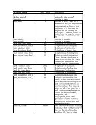
Special <strong>WRF</strong> Output Variables<br />
<strong>WRF</strong> model outputs the state variables defined in the Registry file, and these state<br />
variables are used in the model's prognostic equations. Some of these variables are<br />
perturbation fields. Therefore some definition for reconstructing meteorological variables<br />
is necessary. In particular, the definitions for the following variables are:<br />
total geopotential PH + PHB<br />
total geopotential height in m ( PH + PHB ) / 9.81<br />
total potential temperature in_ K T + 300<br />
total pressure in mb ( P + PB ) * 0.01<br />
wind compoments, grid relative U, V<br />
surface pressure in Pa psfc<br />
surface winds, grid relative U10, V10 (valid at mass points)<br />
surface temperature and mixing ratio T2, Q2<br />
The definition for map projection options:<br />
<strong>WRF</strong>-<strong>ARW</strong> V3: User’s <strong>Guide</strong> 5-58