Create successful ePaper yourself
Turn your PDF publications into a flip-book with our unique Google optimized e-Paper software.
WPS<br />
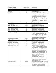
the form field(maskval), where field is the name of the field and maskval is a real value.<br />
Default value is no mask.<br />
13. FILL_MISSING : A real number specifying the value to be assigned to model grid<br />
points that received no interpolated value, for example, because of missing or incomplete<br />
meteorological data. Default value is 1.E20.<br />
14. Z_DIM_NAME : For 3-dimensional meteorological fields, a character string giving<br />
the name of the vertical dimension to be used for the field on output. Default value is<br />
num_metgrid_levels.<br />
15. DERIVED : Either yes or no, indicating whether the field is to be derived from other<br />
interpolated fields, rather than interpolated from an input field. Default value is no.<br />
16. FILL_LEV : The fill_lev keyword, which may be specified multiple times within a<br />
table section, specifies how a level of the field should be filled if that level does not<br />
already exist. A generic value for the keyword takes the form DLEVEL:FIELD(SLEVEL),<br />
where DLEVEL specifies the level in the field to be filled, FIELD specifies the source<br />
field from which to copy levels, and SLEVEL specifies the level within the source field to<br />
use. DLEVEL may either be an integer or the string all. FIELD may either be the name<br />
of another field, the string const, or the string vertical_index. If FIELD is specified as<br />
const, then SLEVEL is a constant value that will be used to fill with; if FIELD is<br />
specified as vertical_index, then (SLEVEL) must not be specified, and the value of the<br />
vertical index of the source field is used; if DLEVEL is 'all', then all levels from the field<br />
specified by the level_template keyword are used to fill the corresponding levels in the<br />
field, one at a time. No default value.<br />
17. LEVEL_TEMPLATE : A character string giving the name of a field from which a list<br />
of vertical levels should be obtained and used as a template. This keyword is used in<br />
conjunction with a fill_lev specification that uses all in the DLEVEL part of its<br />
specification. No default value.<br />
18. MASKED : Either land or water, indicating whether the field is invalid over land or<br />
water, respectively. When a field is masked, or invalid, the static LANDMASK field will<br />
be used to determine which model grid points the field should be interpolated to; invalid<br />
points will be assigned the value given by the FILL_MISSING keyword. Default value is<br />
null (i.e., the field is valid for both land and water points).<br />
19. MISSING_VALUE : A real number giving the value in the input field that is assumed<br />
to represent missing data. No default value.<br />
20. VERTICAL_INTERP_OPTION : A character string specifying the vertical<br />
interpolation method that should be used when vertically interpolating to missing points.<br />
Currently, this option is not implemented. No default value.<br />
<strong>WRF</strong>-<strong>ARW</strong> V3: User’s <strong>Guide</strong> 3-50