You also want an ePaper? Increase the reach of your titles
YUMPU automatically turns print PDFs into web optimized ePapers that Google loves.
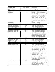
WPS<br />
information specified by the user in the “geogrid” namelist record of the WPS namelist<br />
file, namelist.wps. In addition to computing the latitude, longitude, and map scale factors<br />
at every grid point, geogrid will interpolate soil categories, land use category, terrain<br />
height, annual mean deep soil temperature, monthly vegetation fraction, monthly albedo,<br />
maximum snow albedo, and slope category to the model grids by default. Global data sets<br />
for each of these fields are provided through the <strong>WRF</strong> download page, and, because these<br />
data are time-invariant, they only need to be downloaded once. Several of the data sets<br />
are available in only one resolution, but others are made available in resolutions of 30",<br />
2', 5', and 10'; here, " denotes arc seconds and ' denotes arc minutes. The user need not<br />
download all available resolutions for a data set, although the interpolated fields will<br />
generally be more representative if a resolution of data near to that of the simulation<br />
domain is used. However, users who expect to work with domains having grid spacings<br />
that cover a large range may wish to eventually download all available resolutions of the<br />
static terrestrial data.<br />
Besides interpolating the default terrestrial fields, the geogrid program is general enough<br />
to be able to interpolate most continuous and categorical fields to the simulation domains.<br />
New or additional data sets may be interpolated to the simulation domain through the use<br />
of the table file, GEOGRID.TBL. The GEOGRID.TBL file defines each of the fields that<br />
will be produced by geogrid; it describes the interpolation methods to be used for a field,<br />
as well as the location on the file system where the data set for that field is located.<br />
Output from geogrid is written in the <strong>WRF</strong> I/O API format, and thus, by selecting the<br />
NetCDF I/O format, geogrid can be made to write its output in NetCDF for easy<br />
visualization using external software packages, including ncview, NCL, and the new<br />
release of RIP4.<br />
Program ungrib<br />
The ungrib program reads GRIB files, "degribs" the data, and writes the data in a simple<br />
format, called the intermediate format (see the section on writing data to the intermediate<br />
format for details of the format). The GRIB files contain time-varying meteorological<br />
fields and are typically from another regional or global model, such as NCEP's NAM or<br />
GFS models. The ungrib program can read GRIB Edition 1 and, if compiled with a<br />
"GRIB2" option, GRIB Edition 2 files.<br />
GRIB files typically contain more fields than are needed to initialize <strong>WRF</strong>. Both versions<br />
of the GRIB format use various codes to identify the variables and levels in the GRIB<br />
file. Ungrib uses tables of these codes – called Vtables, for "variable tables" – to define<br />
which fields to extract from the GRIB file and write to the intermediate format. Details<br />
about the codes can be found in the WMO GRIB documentation and in documentation<br />
from the originating center. Vtables for common GRIB model output files are provided<br />
with the ungrib software.<br />
Vtables are provided for NAM 104 and 212 grids, the NAM AWIP format, GFS, the<br />
NCEP/NCAR Reanalysis archived at NCAR, RUC (pressure level data and hybrid<br />
<strong>WRF</strong>-<strong>ARW</strong> V3: User’s <strong>Guide</strong> 3-3