You also want an ePaper? Increase the reach of your titles
YUMPU automatically turns print PDFs into web optimized ePapers that Google loves.
<strong>WRF</strong>-VAR<br />
Before running obsproc.exe, create the required namelist file namelist.obsproc (see<br />
<strong>WRF</strong>DA/var/obsproc/README.namelist, or the section Description of Namelist Variables<br />
for details).<br />
For your reference, an example file named “namelist_obsproc.3dvar.wrfvar-tut”<br />
has already been created in the var/obsproc directory. Thus, proceed as follows.<br />
> cp namelist.obsproc.3dvar.wrfvar-tut namelist.obsproc<br />
Next, edit the namelist file namelist.obsproc by changing the following variables to<br />
accommodate your experiments.<br />
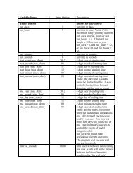
obs_gts_filename='obs.2008020512'<br />
time_window_min = '2008-02-05_11:00:00',: The earliest time edge as ccyy-mm-dd_hh:mn:ss<br />
time_analysis = '2008-02-05_12:00:00', : The analysis time as ccyy-mm-dd_hh:mn:ss<br />
time_window_max = '2008-02-05_13:00:00',: The latest time edge as ccyy-mm-dd_hh:mn:ss<br />
use_for = '3DVAR', ; used for 3D-Var, default<br />
To run OBSPROC, type<br />
> obsproc.exe >&! obsproc.out<br />
Once obsproc.exe has completed successfully, you will see an observation data file,<br />
obs_gts_2008-02-05_12:00:00.3DVAR, in the obsproc directory. This is the input observation<br />
file to <strong>WRF</strong>-Var.<br />
obs_gts_2008-02-05_12:00:00.3DVAR is an ASCII file that contains a header section<br />
(listed below) followed by observations. The meanings and format of observations in the<br />
file are described in the last six lines of the header section.<br />
TOTAL = 9066, MISS. =-888888.,<br />
SYNOP = 757, METAR = 2416, SHIP = 145, BUOY = 250, BOGUS = 0, TEMP =<br />
86,<br />
AMDAR = 19, AIREP = 205, TAMDAR= 0, PILOT = 85, SATEM = 106, SATOB =<br />
2556,<br />
GPSPW = 187, GPSZD = 0, GPSRF = 3, GPSEP = 0, SSMT1 = 0, SSMT2 =<br />
0,<br />
TOVS = 0, QSCAT = 2190, PROFL = 61, AIRSR = 0, OTHER = 0,<br />
PHIC = 40.00, XLONC = -95.00, TRUE1 = 30.00, TRUE2 = 60.00, XIM11 = 1.00, XJM11 =<br />
1.00,<br />
base_temp= 290.00, base_lapse= 50.00, PTOP = 1000., base_pres=100000.,<br />
base_tropo_pres= 20000., base_strat_temp= 215.,<br />
IXC = 60, JXC = 90, IPROJ = 1, IDD = 1, MAXNES= 1,<br />
NESTIX= 60,<br />
NESTJX= 90,<br />
NUMC = 1,<br />
DIS = 60.00,<br />
NESTI = 1,<br />
NESTJ = 1,<br />
INFO = PLATFORM, DATE, NAME, LEVELS, LATITUDE, LONGITUDE, ELEVATION, ID.<br />
SRFC = SLP, PW (DATA,QC,ERROR).<br />
EACH = PRES, SPEED, DIR, HEIGHT, TEMP, DEW PT, HUMID (DATA,QC,ERROR)*LEVELS.<br />
INFO_FMT = (A12,1X,A19,1X,A40,1X,I6,3(F12.3,11X),6X,A40)<br />
SRFC_FMT = (F12.3,I4,F7.2,F12.3,I4,F7.3)<br />
EACH_FMT = (3(F12.3,I4,F7.2),11X,3(F12.3,I4,F7.2),11X,3(F12.3,I4,F7.2))<br />
#------------------------------------------------------------------------------#<br />
…… observations ………<br />
Before running <strong>WRF</strong>-Var, you may like to learn more about various types of data that<br />
will be passed to <strong>WRF</strong>-Var for this case, for example, their geographical distribution, etc.<br />
<strong>WRF</strong>-<strong>ARW</strong> V3: User’s <strong>Guide</strong> 6-9