

GEO Cartagena.pdf - Programa de Naciones Unidas para el Medio ...
GEO Cartagena.pdf - Programa de Naciones Unidas para el Medio ...
GEO Cartagena.pdf - Programa de Naciones Unidas para el Medio ...

Create successful ePaper yourself
Turn your PDF publications into a flip-book with our unique Google optimized e-Paper software.
<strong>GEO</strong> <strong>Cartagena</strong><br />
165<br />
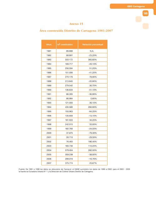
Anexo 15<br />
Área construida Distrito <strong>de</strong> <strong>Cartagena</strong> 1981-2007<br />
Años m 2 construidos Variación porcentual<br />
1981 89.688 N.A.<br />
1982 68.891 -23,20%<br />
1983 333.172 383,60%<br />
1984 169.717 -49,10%<br />
1985 256.594 51,20%<br />
1986 151.006 -41,20%<br />
1987 270.176 78,90%<br />
1988 213.845 -20,90%<br />
1989 279.542 30,70%<br />
1990 136.633 -51,10%<br />
1991 86.265 -36,90%<br />
1992 86.984 0,80%<br />
1993 121.000 39,10%<br />
1994 435.580 260,00%<br />
1995 155.963 -64,20%<br />
1996 135.600 -13,10%<br />
1997 181.933 34,20%<br />
1998 242.015 33,00%<br />
1999 182.760 -24,50%<br />
2000 37.875 -79,30%<br />
2001 26.710 -29,50%<br />
2002 76.483 186,40%<br />
2003 160.730 110,20%<br />
2004 579.404 260,50%<br />
2005 359.238 -38,00%<br />
2006 299.016 -16,76%<br />
2007 375.774 25,67%<br />
Fuente: De 1981 a 1998 los datos se obtuvieron <strong>de</strong> Camacol; <strong>el</strong> DANE suministro los datos <strong>de</strong> 1999 a 2002; <strong>para</strong> <strong>el</strong> 2003 - 2005<br />
la fuente es Curaduría Urbana N° 1 y la Dirección <strong>de</strong> Control Urbano Distrito <strong>de</strong> <strong>Cartagena</strong>.


