Abrir Documento - Mesa de Concertación para la lucha contra la ...
Abrir Documento - Mesa de Concertación para la lucha contra la ...
Abrir Documento - Mesa de Concertación para la lucha contra la ...

You also want an ePaper? Increase the reach of your titles
YUMPU automatically turns print PDFs into web optimized ePapers that Google loves.
P<strong>la</strong>n Estratégico <strong>de</strong> Desarrollo Regional Concertado Cusco al 2012<br />
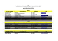
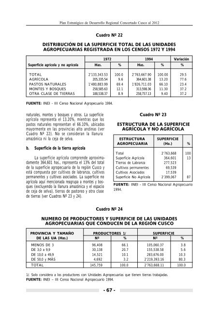
Cuadro Nº 22<br />
DISTRIBUCIÓN DE LA SUPERFICIE TOTAL DE LAS UNIDADES<br />
AGROPECUARIAS REGISTRADA EN LOS CENSOS 1972 Y 1994<br />
1972 1994 Variación<br />
Superficie agríco<strong>la</strong> y no agríco<strong>la</strong> Has. % Has. % %<br />
TOTAL 2’133,343.53 100.0 2’763,667.90 100.00 29.5<br />
AGRÍCOLA 205,335.54 9.6 364,601.38 13.20 77.6<br />
PASTOS NATURALES 1’480,883.99 69.4 1’826,711.03 66.10 23.4<br />
MONTES Y BOSQUES 258,585.63 12.1 313,598.36 11.30 37.2<br />
OTRA CLASE DE TIERRAS 188,538.37 8.9 258,757.13 9.40 37.2<br />
FUENTE: INEI - III Censo Nacional Agropecuario 1994.<br />
naturales, montes y bosques y otros. La superficie<br />
agríco<strong>la</strong> representa el 13.20%, mientras que los<br />
pastos naturales representan el 66.10%, ubicados<br />
mayormente en <strong>la</strong>s provincias alto andinas (ver<br />
Cuadro Nº 22). No se consi<strong>de</strong>ran <strong>la</strong> l<strong>la</strong>nura<br />
amazónica ni <strong>la</strong> ceja <strong>de</strong> selva.<br />
b. Superficie <strong>de</strong> <strong>la</strong> tierra agríco<strong>la</strong><br />
La superficie agríco<strong>la</strong> compren<strong>de</strong> aproximadamente<br />
364,601 has., representa el 13% <strong>de</strong>l total<br />
<strong>de</strong> <strong>la</strong> superficie agropecuaria <strong>de</strong> <strong>la</strong> región Cusco y<br />
está compuesta por cultivos <strong>de</strong> <strong>la</strong>branza, cultivos<br />
permanentes y cultivos asociados. La superficie no<br />
agríco<strong>la</strong> aquí mencionada reagrupa a montes y bosques<br />
(excluyendo <strong>la</strong> l<strong>la</strong>nura amazónica y el espacio<br />
<strong>de</strong> ceja <strong>de</strong> selva), tierras <strong>de</strong> pastoreo y otra c<strong>la</strong>se<br />
<strong>de</strong> tierras (ver Cuadros Nº 23 y 24).<br />
Cuadro Nº 23<br />
ESTRUCTURA DE LA SUPERFICIE<br />
AGRÍCOLA Y NO AGRÍCOLA<br />
ESTRUCTURA SUPERFICIE<br />
AGROPECUARIA (Ha.) %<br />
Total 2’763,668 100<br />
Superficie Agríco<strong>la</strong> 364,601 13<br />
Tierras <strong>de</strong> Labranza 277,523<br />
Cultivos permanentes 69,539<br />
Cultivos Asociados 17,539<br />
Superficie No Agríco<strong>la</strong> 2’399,067 87<br />
FUENTE: INEI - III Censo Nacional Agropecuario<br />
1994.<br />
Cuadro Nº 24<br />
NUMERO DE PRODUCTORES Y SUPERFICIE DE LAS UNIDADES<br />
AGROPECUARIAS QUE CONDUCEN DE LA REGIÓN CUSCO<br />
PROVINCIA Y TAMAÑO PRODUCTORES 1/ SUPERFICIE<br />
DE LAS UA (Has.) Nº % Nº %<br />
MENOS DE 3 96,408 66.1 105,060.37 3.8<br />
DE 3,0 a 9,9 30,138 20.7 155,538.58 5.6<br />
DE 10,0 a 49,9 14,521 10.1 283,676.00 10.3<br />
DE 50,0 y MÁS 4,692 3.2 2’219,393.16 80.3<br />
TOTAL 145,759 100.0 2’763,668.11 100.0<br />
1/. Solo consi<strong>de</strong>ra a los productores con Unida<strong>de</strong>s Agropecuarias que tienen tierras trabajadas.<br />
FUENTE: INEI – III Censo Nacional Agropecuario 1994.<br />
- 67 -