Helsingin seudun taajamakartoitus - Arkisto.gsf.fi - Geologian ...
Helsingin seudun taajamakartoitus - Arkisto.gsf.fi - Geologian ...
Helsingin seudun taajamakartoitus - Arkisto.gsf.fi - Geologian ...

Create successful ePaper yourself
Turn your PDF publications into a flip-book with our unique Google optimized e-Paper software.
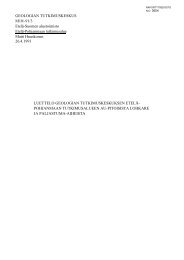
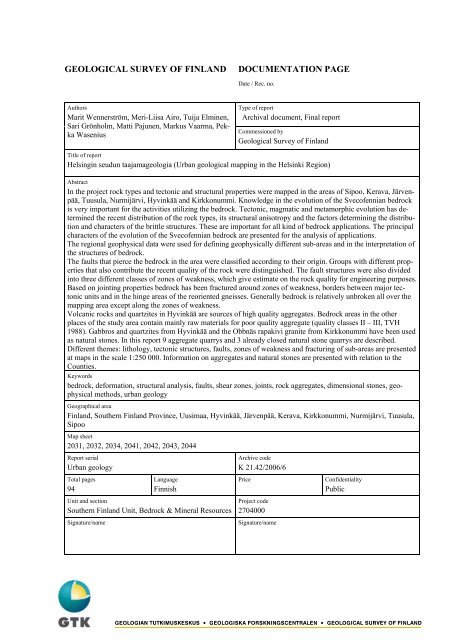
GEOLOGICAL SURVEY OF FINLAND<br />
DOCUMENTATION PAGE<br />
Date / Rec. no.<br />
Authors<br />
Marit Wennerström, Meri-Liisa Airo, Tuija Elminen,<br />
Sari Grönholm, Matti Pajunen, Markus Vaarma, Pekka<br />
Wasenius<br />
Type of report<br />
Archival document, Final report<br />
Commessioned by<br />
Geological Survey of Finland<br />
Title of report<br />
<strong>Helsingin</strong> <strong>seudun</strong> taajamageologia (Urban geological mapping in the Helsinki Region)<br />
Abstract<br />
In the project rock types and tectonic and structural properties were mapped in the areas of Sipoo, Kerava, Järvenpää,<br />
Tuusula, Nurmijärvi, Hyvinkää and Kirkkonummi. Knowledge in the evolution of the Svecofennian bedrock<br />
is very important for the activities utilizing the bedrock. Tectonic, magmatic and metamorphic evolution has determined<br />
the recent distribution of the rock types, its structural anisotropy and the factors determining the distribution<br />
and characters of the brittle structures. These are important for all kind of bedrock applications. The principal<br />
characters of the evolution of the Svecofennian bedrock are presented for the analysis of applications.<br />
The regional geophysical data were used for de<strong>fi</strong>ning geophysically different sub-areas and in the interpretation of<br />
the structures of bedrock.<br />
The faults that pierce the bedrock in the area were classi<strong>fi</strong>ed according to their origin. Groups with different properties<br />
that also contribute the recent quality of the rock were distinguished. The fault structures were also divided<br />
into three different classes of zones of weakness, which give estimate on the rock quality for engineering purposes.<br />
Based on jointing properties bedrock has been fractured around zones of weakness, borders between major tectonic<br />
units and in the hinge areas of the reoriented gneisses. Generally bedrock is relatively unbroken all over the<br />
mapping area except along the zones of weakness.<br />
Volcanic rocks and quartzites in Hyvinkää are sources of high quality aggregates. Bedrock areas in the other<br />
places of the study area contain mainly raw materials for poor quality aggregate (quality classes II – III, TVH<br />
1988). Gabbros and quartzites from Hyvinkää and the Obbnäs rapakivi granite from Kirkkonummi have been used<br />
as natural stones. In this report 9 aggregate quarrys and 3 already closed natural stone quarrys are described.<br />
Different themes: lithology, tectonic structures, faults, zones of weakness and fracturing of sub-areas are presented<br />
at maps in the scale 1:250 000. Information on aggregates and natural stones are presented with relation to the<br />
Counties.<br />
Keywords<br />
bedrock, deformation, structural analysis, faults, shear zones, joints, rock aggregates, dimensional stones, geophysical<br />
methods, urban geology<br />
Geographical area<br />
Finland, Southern Finland Province, Uusimaa, Hyvinkää, Järvenpää, Kerava, Kirkkonummi, Nurmijärvi, Tuusula,<br />
Sipoo<br />
Map sheet<br />
2031, 2032, 2034, 2041, 2042, 2043, 2044<br />
Report serial<br />
Urban geology<br />
Total pages<br />
94<br />
Language<br />
Finnish<br />
Unit and section<br />
Southern Finland Unit, Bedrock & Mineral Resources<br />
Signature/name<br />
Archive code<br />
K 21.42/2006/6<br />
Price<br />
Project code<br />
2704000<br />
Signature/name<br />
Con<strong>fi</strong>dentiality<br />
Public