Projektbericht - Geologische Bundesanstalt
Projektbericht - Geologische Bundesanstalt
Projektbericht - Geologische Bundesanstalt
Erfolgreiche ePaper selbst erstellen
Machen Sie aus Ihren PDF Publikationen ein blätterbares Flipbook mit unserer einzigartigen Google optimierten e-Paper Software.
Ü-LG-32-33/2011<br />
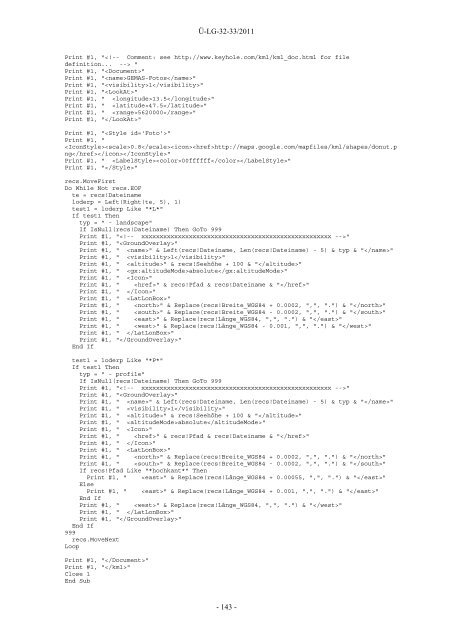
Print #1, " "<br />
Print #1, ""<br />
Print #1, "GEMAS-Fotos"<br />
Print #1, "1"<br />
Print #1, ""<br />
Print #1, " 13.5"<br />
Print #1, " 47.5"<br />
Print #1, " 5620000"<br />
Print #1, ""<br />
Print #1, ""<br />
Print #1, "<br />
0.8http://maps.google.com/mapfiles/kml/shapes/donut.p<br />
ng"<br />
Print #1, " 00ffffff"<br />
Print #1, ""<br />
recs.MoveFirst<br />
Do While Not recs.EOF<br />
te = recs!Dateiname<br />
loderp = Left(Right(te, 5), 1)<br />
test1 = loderp Like "*L*"<br />
If test1 Then<br />
typ = " - landscape"<br />
If IsNull(recs!Dateiname) Then GoTo 999<br />
Print #1, ""<br />
Print #1, ""<br />
Print #1, " " & Left(recs!Dateiname, Len(recs!Dateiname) - 5) & typ & ""<br />
Print #1, " 1"<br />
Print #1, " " & recs!Seehöhe + 100 & ""<br />
Print #1, " absolute"<br />
Print #1, " "<br />
Print #1, " " & recs!Pfad & recs!Dateiname & ""<br />
Print #1, " "<br />
Print #1, " "<br />
Print #1, " " & Replace(recs!Breite_WGS84 + 0.0002, ",", ".") & ""<br />
Print #1, " " & Replace(recs!Breite_WGS84 - 0.0002, ",", ".") & ""<br />
Print #1, " " & Replace(recs!Länge_WGS84, ",", ".") & ""<br />
Print #1, " " & Replace(recs!Länge_WGS84 - 0.001, ",", ".") & ""<br />
Print #1, " "<br />
Print #1, ""<br />
End If<br />
test1 = loderp Like "*P*"<br />
If test1 Then<br />
typ = " - profile"<br />
If IsNull(recs!Dateiname) Then GoTo 999<br />
Print #1, ""<br />
Print #1, ""<br />
Print #1, " " & Left(recs!Dateiname, Len(recs!Dateiname) - 5) & typ & ""<br />
Print #1, " 1"<br />
Print #1, " " & recs!Seehöhe + 100 & ""<br />
Print #1, " absolute"<br />
Print #1, " "<br />
Print #1, " " & recs!Pfad & recs!Dateiname & ""<br />
Print #1, " "<br />
Print #1, " "<br />
Print #1, " " & Replace(recs!Breite_WGS84 + 0.0002, ",", ".") & ""<br />
Print #1, " " & Replace(recs!Breite_WGS84 - 0.0002, ",", ".") & ""<br />
If recs!Pfad Like "*hochkant*" Then<br />
Print #1, " " & Replace(recs!Länge_WGS84 + 0.00055, ",", ".") & ""<br />
Else<br />
Print #1, " " & Replace(recs!Länge_WGS84 + 0.001, ",", ".") & ""<br />
End If<br />
Print #1, " " & Replace(recs!Länge_WGS84, ",", ".") & ""<br />
Print #1, " "<br />
Print #1, ""<br />
End If<br />
999<br />
recs.MoveNext<br />
Loop<br />
Print #1, ""<br />
Print #1, ""<br />
Close 1<br />
End Sub<br />
- 143 -


