Projektbericht - Geologische Bundesanstalt
Projektbericht - Geologische Bundesanstalt
Projektbericht - Geologische Bundesanstalt

Erfolgreiche ePaper selbst erstellen
Machen Sie aus Ihren PDF Publikationen ein blätterbares Flipbook mit unserer einzigartigen Google optimierten e-Paper Software.
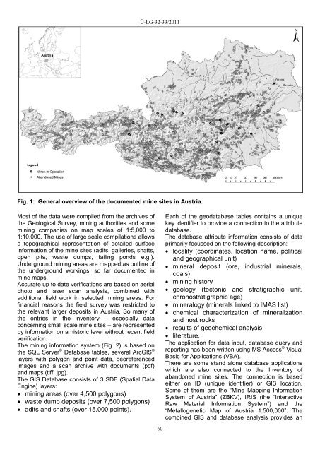
Ü-LG-32-33/2011<br />
Fig. 1: General overview of the documented mine sites in Austria.<br />
Most of the data were compiled from the archives of<br />
the Geological Survey, mining authorities and some<br />
mining companies on map scales of 1:5,000 to<br />
1:10,000. The use of large scale compilations allows<br />
a topographical representation of detailed surface<br />
information of the mine sites (adits, galleries, shafts,<br />
open pits, waste dumps, tailing ponds e.g.).<br />
Underground mining areas are mapped as outline of<br />
the underground workings, so far documented in<br />
mine maps.<br />
Accurate up to date verifications are based on aerial<br />
photo and laser scan analysis, combined with<br />
additional field work in selected mining areas. For<br />
financial reasons the field survey was restricted to<br />
the relevant larger deposits in Austria. So many of<br />
the entries in the inventory – especially data<br />
concerning small scale mine sites – are represented<br />
by information on a historic level without recent field<br />
verification.<br />
The mining information system (Fig. 2) is based on<br />
the SQL Server © Database tables, several ArcGIS ®<br />
layers with polygon and point data, georeferenced<br />
images and a scan archive with documents (pdf)<br />
and maps (tiff, jpg).<br />
The GIS Database consists of 3 SDE (Spatial Data<br />
Engine) layers:<br />
• mining areas (over 4,500 polygons)<br />
• waste dump deposits (over 7,500 polygons)<br />
• adits and shafts (over 15,000 points).<br />
Each of the geodatabase tables contains a unique<br />
key identifier to provide a connection to the attribute<br />
database.<br />
The database attribute information consists of data<br />
primarily focussed on the following description:<br />
• locality (coordinates, location name, political<br />
and geographical unit)<br />
• mineral deposit (ore, industrial minerals,<br />
coals)<br />
• mining history<br />
• geology (tectonic and stratigraphic unit,<br />
chronostratigraphic age)<br />
• mineralogy (minerals linked to IMAS list)<br />
• chemical characterization of mineralization<br />
and host rocks<br />
• results of geochemical analysis<br />
• literature.<br />
The application for data input, database query and<br />
reporting has been written using MS Access ® Visual<br />
Basic for Applications (VBA).<br />
There are some stand alone database applications<br />
which are also connected to the Inventory of<br />
abandoned mine sites. The connection is based<br />
either on ID (unique identifier) or GIS location.<br />
Some of them are the “Mine Mapping Information<br />
System of Austria” (ZBKV), IRIS (the “Interactive<br />
Raw Material Information System”) and the<br />
“Metallogenetic Map of Austria 1:500,000”. The<br />
combined GIS and database analysis provides an<br />
- 60 -