- Page 1:
U G A N D A Atlas of Our Changing E
- Page 4 and 5:
© 2009, National Enviornment Manag
- Page 6 and 7:
Chapter 2: Uganda’s Changing Envi
- Page 8 and 9:
Foreword Hon. Maria Mutagamba MINIS
- Page 10 and 11:
Sunset over Europe and Africa A dig
- Page 12 and 13:
The beautiful ridges landscape in K
- Page 14 and 15:
x Display of Jupiter, Venus and the
- Page 16 and 17:
Figure 2: The Geology of Uganda 2 G
- Page 18 and 19:
Uganda experiences moderate tempera
- Page 20 and 21:
Rainfall distribution Figure 3: Uga
- Page 22 and 23:
Zone 1: Lake Victoria Basin Zone 2:
- Page 24 and 25:
A degraded lake-shore catchment zon
- Page 26 and 27:
Lake Water Levels Lake Victoria hig
- Page 28 and 29:
14 River Basins, Lakes and Wetlands
- Page 30 and 31:
Figure 8: Uganda’s water potentia
- Page 32 and 33:
The water problem in Kamuli Distric
- Page 34 and 35:
Figure 9: Uganda’s Land Cover Cla
- Page 36 and 37:
Terraced gardens and intensive tree
- Page 38 and 39:
22 Wetlands: about 33,000 km 2 ; 13
- Page 40 and 41:
Name of Ramsar site Year of Site Ar
- Page 42 and 43:
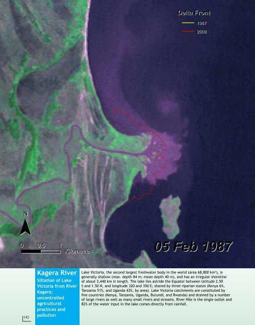
Wetlands: importance and uses 28 Ug
- Page 44 and 45:
Wetlands: threats Indiscriminate du
- Page 46 and 47:
Wetlands: interventions Wetland res
- Page 48 and 49:
Plant a tree for the future: A girl
- Page 50 and 51:
An early morning ride through a coo
- Page 52 and 53:
Conservation areas: Protected areas
- Page 54 and 55:
The Delta in Murchison Falls Nation
- Page 56 and 57:
Kabwoya Wildlife Reserve Map of Kab
- Page 58 and 59:
Figure 13: The major soils of Ugand
- Page 60 and 61:
Soils: Agro-Ecological Zones Agro-E
- Page 62 and 63:
48 Agro-Ecological Rainfall Minimum
- Page 64 and 65:
Energy: Hydro electric power Above:
- Page 66 and 67:
Energy: different sources of energy
- Page 68 and 69:
Kasese Cobalt Trail left by acidic
- Page 70 and 71:
More pictures of Game parks /wildli
- Page 72 and 73:
Kiruhura 1990 58 K I R U Kiruhura I
- Page 74 and 75:
Karamoja 60 Karamoja Increase in ag
- Page 76 and 77:
62 Kibimba Rice Scheme Ten years ag
- Page 78 and 79:
Mabira 2001 Mabira forest 2001 64 M
- Page 80 and 81:
Part of the Mabira Tropical High Fo
- Page 82 and 83:
Katuugo Forest 1990, Nakasongola Di
- Page 84 and 85:
70 Budongo Forest Reserve Decreased
- Page 86 and 87:
72 Budongo fire fronts 2002 Budongo
- Page 88 and 89:
74 Katuugo Forest Reserve Loss of v
- Page 90 and 91:
76 Mwenge - Mafuga Forest Reserves
- Page 92 and 93:
Rhino camp 1975 78 Pader Refugee ca
- Page 94 and 95:
80 Kooki Hills Area Degraded hills
- Page 96 and 97:
Kooki hills in Kibaale-Bukoora, Rak
- Page 98 and 99:
Rainy season: Kooki hills in the ba
- Page 100 and 101:
86 Mt. Elgon National Park Conserva
- Page 102 and 103:
Dawn at the Mt. Elgon Ranges (2008)
- Page 104 and 105:
90 Lake Wamala Wetland degradation
- Page 106 and 107: 92 Lake Bunyonyi - Iyamuriro Wetlan
- Page 108 and 109: Aerial view of Kabale-Iyamuriro wet
- Page 110 and 111: 96 Lake Mutanda Rapid silting and w
- Page 112 and 113: Lake Mutanda: Heavily converted Git
- Page 114 and 115: 100 Laropi- Moyo lakes/ lagoons Flo
- Page 116 and 117: Shifted bridge as result of floodin
- Page 118 and 119: 104 Teso region Flooding The northe
- Page 120 and 121: 106 Kampala Urbanisation and indust
- Page 122 and 123: Kampala City (2007). Inset: Kampala
- Page 124 and 125: 110 . . . . .
- Page 126 and 127: 112 Naguru-Kololo in 1959 In 1959,
- Page 128 and 129: Bugolobi in 1959 Unplanned settleme
- Page 130 and 131: 116 Flood prone area at Clock Tower
- Page 132 and 133: 118 Construction in the Nsooba-Lubi
- Page 134 and 135: 120 Construction in waterways at Za
- Page 136 and 137: 122 Construction of houses in Nakiv
- Page 138 and 139: 124 Kampala-Jinja Highway Naguru Ho
- Page 140 and 141: Biomass Land use/land cover Land us
- Page 142 and 143: Positive impacts of Kampala’s cha
- Page 144 and 145: A Some of the landmarks in the midd
- Page 146 and 147: 132 NEMA 2008
- Page 148 and 149: Mt. Elgon borders Uganda and Kenya
- Page 150 and 151: 136 Mt. Rwenzori Glaciers Global wa
- Page 152 and 153: 138 River Semliki Eroded banks of R
- Page 154 and 155: A herd of cattle grazing and wateri
- Page 158 and 159: 144 Lake Victoria Green algae bloom
- Page 160 and 161: 146 Lake Kyoga Shallow lake, unstab
- Page 162 and 163: NEMA staff and Lira District offici
- Page 164 and 165: 150 Kasyoha- Kitomi Forest Reserve
- Page 166 and 167: 152 Rhino Refugee camp Impact of re
- Page 168 and 169: Misuse of seasonal wetlands: Teso f
- Page 170 and 171: Uganda’s economy More than 73% of
- Page 172 and 173: Millennium Development Goals (MDGs)
- Page 174 and 175: MDG 7: Ensure Environmental Sustain
- Page 176 and 177: The 2000-2005 growth rate in Africa
- Page 178 and 179: Uganda is divided into four regions
- Page 180 and 181: Literacy rate Literacy rates as a m
- Page 182 and 183: Tourism and the Environment Uganda
- Page 184 and 185: Land use and land cover Over 36 per
- Page 186 and 187: Forest Reserves Central Forest Rese
- Page 188 and 189: and Ntungamo had the percentage of
- Page 190 and 191: Latrine Coverage The use of proper
- Page 192 and 193: Energy for cooking in 2005-2006 Ove
- Page 194 and 195: Arable land Almost all Uganda’s l
- Page 196 and 197: 182 Recommendations 1. Efforts to r
- Page 198 and 199: 184 Kika Group, a local dance troup
- Page 200 and 201: Wildlife Where is my food- The Gira
- Page 202 and 203: Biodiversity Ecotourism: Heart-shap
- Page 204 and 205: 190 Areas of interest Houses of Par
- Page 206 and 207:
A modern country homestead near Mba
- Page 208 and 209:
Places of worship Namirembe Cathedr
- Page 210 and 211:
Traditional aspects Gisu Imbalu (ci
- Page 212 and 213:
Crater lakes in Uganda 198
- Page 214 and 215:
Acronyms AEZ Agro-ecological Zoning
- Page 216 and 217:
Index A Abim 60,181 Abstraction 18
- Page 218 and 219:
Montane forests 90 Moon x Moroto 60
- Page 220:
The Uganda Atlas of Our Changing En