

Uganda Atlas of Our Changing Environment - GRID-Arendal
Uganda Atlas of Our Changing Environment - GRID-Arendal
Uganda Atlas of Our Changing Environment - GRID-Arendal

Create successful ePaper yourself
Turn your PDF publications into a flip-book with our unique Google optimized e-Paper software.
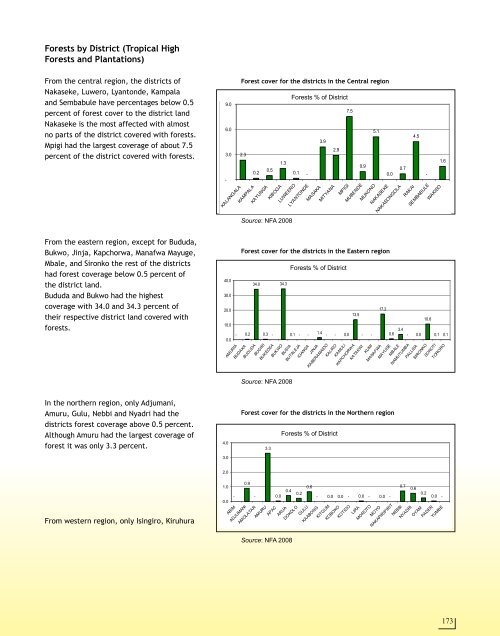
Forests by District (Tropical High<br />
Forests and Plantations)<br />
From the central region, the districts <strong>of</strong><br />
Nakaseke, Luwero, Lyantonde, Kampala<br />
and Sembabule have percentages below 0.5<br />
percent <strong>of</strong> forest cover to the district land<br />
Nakaseke is the most affected with almost<br />
no parts <strong>of</strong> the district covered with forests.<br />
Mpigi had the largest coverage <strong>of</strong> about 7.5<br />
percent <strong>of</strong> the district covered with forests.<br />
From the eastern region, except for Bududa,<br />
Bukwo, Jinja, Kapchorwa, Manafwa Mayuge,<br />
Mbale, and Sironko the rest <strong>of</strong> the districts<br />
had forest coverage below 0.5 percent <strong>of</strong><br />
the district land.<br />
Bududa and Bukwo had the highest<br />
coverage with 34.0 and 34.3 percent <strong>of</strong><br />
their respective district land covered with<br />
forests.<br />
In the northern region, only Adjumani,<br />
Amuru, Gulu, Nebbi and Nyadri had the<br />
districts forest coverage above 0.5 percent.<br />
Although Amuru had the largest coverage <strong>of</strong><br />
forest it was only 3.3 percent.<br />
From western region, only Isingiro, Kiruhura<br />
9.0<br />
6.0<br />
3.0<br />
-<br />
KALANGALA<br />
40.0<br />
30.0<br />
20.0<br />
10.0<br />
4.0<br />
3.0<br />
2.0<br />
1.0<br />
0.0<br />
0.0<br />
Forest cover for the districts in the Central region<br />
2.3<br />
KAMPALA<br />
0.2<br />
KAYUNGA<br />
0.5<br />
KIBOGA<br />
1.3<br />
LUWEERO<br />
Source: NFA 2008<br />
0.1 -<br />
LYANTONDE<br />
MASAKA<br />
Forests % <strong>of</strong> District<br />
Forest cover for the districts in the Eastern region<br />
- 0.2<br />
AMURIA<br />
BUDAKA<br />
-<br />
34.0<br />
BUDUDA<br />
BUGIRI<br />
0.3 -<br />
34.3<br />
Source: NFA 2008<br />
0.1 - -<br />
Forest cover for the districts in the Northern region<br />
0.9<br />
-<br />
3.3<br />
0.0<br />
0.4<br />
Source: NFA 2008<br />
Forests % <strong>of</strong> District<br />
3.9<br />
MITYANA<br />
BUKEDEA<br />
BUKWO<br />
BUSIA<br />
BUTALEJA<br />
IGANGA<br />
JINJA<br />
KABERAMAIDO<br />
2.9<br />
7.5<br />
MPIGI<br />
Forests % <strong>of</strong> District<br />
0.2<br />
0.6<br />
Forests % <strong>of</strong> District<br />
1.4 - - 0.0<br />
KALIRO<br />
KAMULI<br />
Forests % <strong>of</strong> District<br />
Forests % <strong>of</strong> District<br />
0.9<br />
MUBENDE<br />
13.5<br />
5.1<br />
MUKONO<br />
- -<br />
KAPCHORWA<br />
KATAKWI<br />
KUMI<br />
NAKASEKE<br />
0.0<br />
NAKASONGOLA<br />
17.2<br />
0.6<br />
0.7<br />
3.4<br />
MANAFWA<br />
MAYUGE<br />
MBALE<br />
- 0.0 0.0 - 0.0 - 0.0 -<br />
0.7<br />
RAKAI<br />
4.5<br />
-<br />
SEMBABULE<br />
- 0.0<br />
10.6<br />
WAKISO<br />
1.6<br />
0.1 0.1<br />
NAMUTUMBA<br />
PALLISA<br />
SIRONKO<br />
SOROTI<br />
TORORO<br />
0.6<br />
0.2<br />
0.0 -<br />
ABIM<br />
ADJUMANI<br />
AMOLATAR<br />
AMURU<br />
APAC<br />
ARUA<br />
DOKOLO<br />
GULU<br />
KAABONG<br />
KITGUM<br />
KOBOKO<br />
KOTIDO<br />
LIRA<br />
MOROTO<br />
MOYO<br />
NAKAPIRIPIRIT<br />
NEBBI<br />
NYADRI<br />
OYAM<br />
PADER<br />
YUMBE<br />
173


