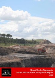
HVO 2009 Annual Environmental Management Report - Final
HVO 2009 Annual Environmental Management Report - Final
HVO 2009 Annual Environmental Management Report - Final

You also want an ePaper? Increase the reach of your titles
YUMPU automatically turns print PDFs into web optimized ePapers that Google loves.
Coal & Allied – Hunter Valley Operations<br />
Water Inputs<br />
Water was supplied predominantly from three sources in <strong>2009</strong>:<br />
Surplus mine water stored in pit;<br />
<br />
Intercepted runoff water; and<br />
Groundwater percolation into the open cut.<br />
A total of 564mm of rainfall was recorded at <strong>HVO</strong> in <strong>2009</strong> producing an estimated 7,485ML of runoff from<br />
approximately 4,500ha of developed, disturbed and mining catchments. Water falling on undisturbed clean<br />
water catchments is diverted off site into natural systems where possible. Rainfall runoff was the largest input<br />
to the site mine water balance in <strong>2009</strong>.<br />
Groundwater contributed approximately 1,251ML to the site water supply.<br />
Independent groundwater Modelling of the pits which comprise <strong>HVO</strong> indicate a portion of total groundwater is<br />
contributed from connected Hunter River alluviums. Table 14 lists the Modelled amounts of water entering the<br />
pit and the reference from which the number is generated.<br />
Alluvial groundwater intercepted in North Pit was measured based on pump out rates during active mining in<br />
this area. Since that time the pit has been back filled with spoil and the water level has risen to the base of the<br />
barrier wall, hence seepage from the river alluvium will have reduced significantly. The seepage figure<br />
provided is considered an overestimate. No Modelling has been undertaken to determine seepage rates with<br />
the current conditions in North Pit.<br />
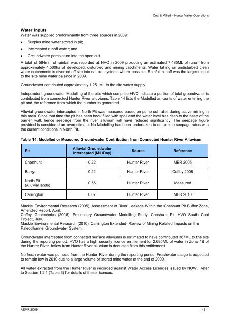
Table 14: Modelled or Measured Groundwater Contribution from Connected Hunter River Alluvium<br />
Pit<br />
Alluvial Groundwater<br />
Intercepted (ML/Day)<br />
Source<br />
Reference<br />
Cheshunt 0.22 Hunter River MER 2005<br />
Barrys 0.22 Hunter River Coffey 2008<br />
North Pit<br />
(Alluvial lands)<br />
0.55 Hunter River Measured<br />
Carrington 0.07 Hunter River MER 2010<br />
Mackie <strong>Environmental</strong> Research (2005), Assessment of River Leakage Within the Cheshunt Pit Buffer Zone,<br />
Amended <strong>Report</strong>, April.<br />
Coffey Geotechnics (2008), Preliminary Groundwater Modelling Study, Cheshunt Pit, <strong>HVO</strong> South Coal<br />
Project, July.<br />
Mackie <strong>Environmental</strong> Research (2010), Carrington Extended- Review of Mining Related Impacts on the<br />
Paleochannel Groundwater System.<br />
Groundwater intercepted from connected surface alluviums is estimated to have contributed 387ML to the site<br />
during the reporting period. <strong>HVO</strong> has a high security licence entitlement for 2,685ML of water in Zone 1B of<br />
the Hunter River. Inflow from Hunter River alluvium is deducted from this entitlement.<br />
No fresh water was pumped from the Hunter River during the reporting period. Freshwater usage is expected<br />
to remain low in 2010 due to a large volume of stored mine water at the end of <strong>2009</strong>.<br />
All water extracted from the Hunter River is recorded against Water Access Licences issued by NOW. Refer<br />
to Section 1.2.1 (Table 3) for details of these licences.<br />
AEMR <strong>2009</strong> 42