Source - Vi.potsdam.ny.us - Potsdam
Source - Vi.potsdam.ny.us - Potsdam
Source - Vi.potsdam.ny.us - Potsdam

Create successful ePaper yourself
Turn your PDF publications into a flip-book with our unique Google optimized e-Paper software.
<strong>Potsdam</strong> Municipal Airport - Master Plan – Phase 1 Report<br />
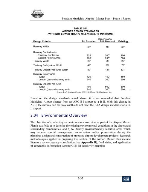
TABLE 2-11<br />
AIRPORT DESIGN STANDARDS<br />
(WITH NOT LOWER THAN ¾ MILE VISIBILITY MINIMUMS)<br />
Dimensions<br />
Design Criteria: B-I Standard B-II Standard Existing<br />
Runway Width 60’ 75’ 60’<br />
Runway Centerline to<br />
- Taxiway Centerline<br />
- Aircraft Parking Area<br />
225’<br />
200’<br />
240’<br />
250’<br />
400’<br />
500’<br />
Taxiway Width 25’ 35' 25’<br />
Taxiway Safety Area Width 49’ 79' 79’<br />
Taxiway Object Free Area Width 89’ 131' 131’<br />
Runway Safety Area<br />
- Width<br />
- Length (beyond runway end)<br />
Runway Object Free Area<br />
- Width<br />
- Length (beyond runway end)<br />
120’<br />
240’<br />
400’<br />
240’<br />
150'<br />
300'<br />
500'<br />
300'<br />
<strong>Source</strong>: FAA Advisory Circular 150/5300-13 and C&S Engineers, Inc.<br />
150’<br />
300’<br />
500’<br />
300’<br />
Based on the design standards noted above, it is recommended that <strong>Potsdam</strong><br />
Municipal Airport change from an ARC B-I airport to a B-II. With this change in<br />
ARC, the runway and taxiway widths do not meet the FAA design standards for a B-<br />
II airport.<br />
2.04 Environmental Overview<br />
The objective of conducting an environmental overview as part of the Airport Master<br />
Plan is twofold: a) to describe the existing environmental conditions in the airport and<br />
surrounding communities, and b) to identify environmentally sensitive areas which<br />
may require special management, conservation and/or preservation during the<br />
planning, design and construction of proposed airport development projects. Research<br />
methodologies applied in preparing this section of the Airport Master Plan include<br />
literature review, agency consultation (see Appendix B), field visits, and application<br />
of geographic information system (GIS) for sensitivity mapping.<br />
2-32