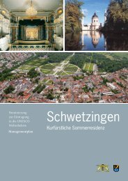
II. - Schloss Schwetzingen
II. - Schloss Schwetzingen
II. - Schloss Schwetzingen

You also want an ePaper? Increase the reach of your titles
YUMPU automatically turns print PDFs into web optimized ePapers that Google loves.
still characterized by the alterations made in<br />
Carl Theodor’s time, and by Bibiena’s plans<br />
based on the principles of Absolutist town<br />
planning (see Fig. 5). 39<br />
The important existing roads to Oftersheim<br />
and Mannheim had been improved and made<br />
up; the road to Mannheim had been straightened<br />
in parts. 40 By the 1760s, parts of the<br />
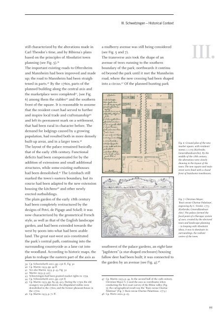
planned building along the central axis and<br />
the marketplace were completed 41 , (see Fig.<br />
6) among them the stables 42 and the southern<br />
front of the square. It is reasonable to assume<br />
that the resident court had served to further<br />
and inspire local trade and craftsmanship 43<br />
and left its permanent mark on a settlement,<br />
that had been rural in character before. The<br />
demand for lodgings caused by a growing<br />
population, had resulted both in more densely<br />
built-up areas, and in a larger town. 44<br />
The layout of the palace remained basically<br />
that of the early 18th century. Functional<br />
defi cits had been compensated for by the<br />
addition of extensions and small additional<br />
structures, while some existing outhouses<br />
had been demolished. 45 The Leimbach still<br />
marked the town’s eastern boundary, but its<br />
course had been adapted to the new extension<br />
housing the kitchens 46 and other newly<br />
erected outbuildings.<br />
The plain garden of the early 18th century<br />
had been completely restructured by the<br />
designs of Petri, de Pigage and Sckell; it was<br />
now characterized by the geometrical French<br />
style, as well as that of the English landscape<br />
garden, and had been extended towards the<br />
west by 900m into what had been arable<br />
land. The great east-west axis constituted<br />
the park’s central path, continuing into the<br />
surrounding countryside as a lane cut into<br />
the woodland. According to historic maps, the<br />
plan to reshape the eastern part of the axis as<br />
39 Cp. Schweinfurth 2001, pp. 236 ff., Fig. 3a<br />
40 Cp. Martin 1933, pp. 44 ff.<br />
41 See also Martin 1933, p. 43, Fig. 32.<br />
42 Martin 1933, p. 427.<br />
43 <strong>Schwetzingen</strong> had been granted market rights in 1759.<br />
44 Cp. Schweinfurth 2001, pp. 236 ff.<br />
45 Cp. Martin 1933, pp. 89, 95, 423. During the 1750s the old<br />
orangery was pulled down; the dilapidated stables were<br />
demolished in the 1760s, and the former pheasant-house in<br />
the 1770s.<br />
46 Cp. Martin 1933, p. 71 ff.<br />
<strong>II</strong>I. <strong>Schwetzingen</strong> – Historical Context<br />
a mulberry avenue was still being considered<br />
(see Fig. 5 and 7).<br />
The transverse axis took the shape of an<br />
avenue of trees running to the southern<br />
boundary of the park; northwards it continued<br />
beyond the park until it met the Mannheim<br />
road, where the new crossing had been shaped<br />
into a circus. 47 Of the planned hunting park<br />
southwest of the palace gardens, an eight-lane<br />
“Jagdstern” (a star-shaped enclosure) housing<br />
fallow deer had been built; it was connected to<br />
the garden by an avenue (see Fig. 4). 48<br />
47 Cp. Martin 1933, p. 44. In the second half of the 19th century,<br />
Christian Mayer S. J. used the axes as coordinates when<br />
conducting the fi rst exact survey of the Rhine valley (Fig.<br />
5); the cartographical result was the “Basis novae Chartae<br />
Palatinae” (Fig. 7: Basis novae Chartae Palantinae. 1773.)<br />
48 Cp. Wertz 2002, p. 25.<br />
<strong>II</strong>I.<br />
Fig. 6: Ground plan of the new<br />
market square, with residents’<br />
names, c.1775 (Karlsruhe,<br />
Generallandesarchiv). By the<br />
middle of the 18th century,<br />
the alterations were clearly<br />
showing in the layout of the<br />
town. The new square and main<br />
street were lined with a closed<br />
front of handsome townhouses.<br />
Fig. 7: Christian Mayer,<br />
‘Basis novae Chartae Palatinae’,<br />
engraving by C. Verelst, 1773<br />
(Karlsruhe, Generallandesarchiv).<br />
The palace formed the<br />
focal point of a Baroque system<br />
of axes, created by the electoral<br />
town and landscape planning<br />
– in keeping with Absolutist<br />
ideas, it was to dominate its<br />
surroundings, the radiant<br />
centre of the town.<br />
95