
Create successful ePaper yourself
Turn your PDF publications into a flip-book with our unique Google optimized e-Paper software.
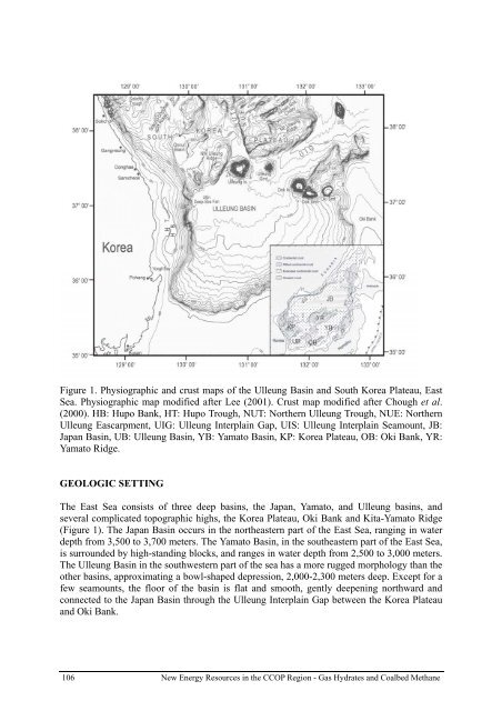
Figure 1. Physiographic and crust maps of the Ulleung Basin and South Korea Plateau, East<br />
Sea. Physiographic map modified after Lee (2001). Crust map modified after Chough et al.<br />
(2000). HB: Hupo Bank, HT: Hupo Trough, NUT: Northern Ulleung Trough, NUE: Northern<br />
Ulleung Eascarpment, UIG: Ulleung Interplain Gap, UIS: Ulleung Interplain Seamount, JB:<br />
Japan Basin, UB: Ulleung Basin, YB: Yamato Basin, KP: Korea Plateau, OB: Oki Bank, YR:<br />
Yamato Ridge.<br />
GEOLOGIC SETTING<br />
The East Sea consists of three deep basins, the Japan, Yamato, and Ulleung basins, and<br />
several complicated topographic highs, the Korea Plateau, Oki Bank and Kita-Yamato Ridge<br />
(Figure 1). The Japan Basin occurs in the northeastern part of the East Sea, ranging in water<br />
depth from 3,500 to 3,700 meters. The Yamato Basin, in the southeastern part of the East Sea,<br />
is surrounded by high-standing blocks, and ranges in water depth from 2,500 to 3,000 meters.<br />
The Ulleung Basin in the southwestern part of the sea has a more rugged morphology than the<br />
other basins, approximating a bowl-shaped depression, 2,000-2,300 meters deep. Except for a<br />
few seamounts, the floor of the basin is flat and smooth, gently deepening northward and<br />
connected to the Japan Basin through the Ulleung Interplain Gap between the Korea Plateau<br />
and Oki Bank.<br />
106<br />
New Energy Resources in the <strong>CCOP</strong> Region - Gas Hydrates and Coalbed Methane