
You also want an ePaper? Increase the reach of your titles
YUMPU automatically turns print PDFs into web optimized ePapers that Google loves.
The Korea Plateau includes a northern component (North Korea Plateau) and a southern<br />
component (South Korea Plateau), bordered by the Sokcho Trough connected to the<br />
southwestern part of the Japan Basin (Figure 1). The South Korea Plateau comprises rifted<br />
continental crust in its western part and fragmented continental crust in its eastern part (Figure<br />
1; Tamaki, 1988; Jolivet et al., 1991). To the north of Ulleung Island, a trough deepens<br />
northward along the North Ulleung Escarpment and extends to the Japan Basin (Figure 1).<br />
The South Korea Plateau can be divided further into western and eastern segments, separated<br />
by the North Ulleung Escarpment (or Trough) (Figure 1; Chough et al., 2000).<br />
SUMMARY OF PREVIOUS RESEARCH<br />
The mass flow processes in the Ulleung Basin and Korea Plateau were originally reported by<br />
Chough (1982, 1983, 1984). Following multi-channel seismic reflection surveys and drilling<br />
of the Dolgorae exploratory well by the Korea Petroleum Development Corporation<br />
(PEDCO) in the late 1980’s, many further geological and geophysical studies of the Ulleung<br />
Basin were carried out (Chough and Lee, 1992; Yoon and Chough, 1995; Chough et al., 1997;<br />
Lee and Suk, 1998; Lee et al., 2001; Lee and Kim, 2002). Chough and Barg (1987) outlined a<br />
suggested tectonic history of the margin of the Ulleung Basin and Chough and Lee (1987)<br />
first analysed the slope stability of the western margin of the Ulleung Basin.<br />
In the 1990’s, a few seismic stratigraphic schemes for the Ulleung Basin were suggested<br />
(Chough and Lee, 1992; Yoon, 1994; Yoon and Chough, 1995; Chough et al., 1997; Lee and<br />
Suk, 1998). These stratigraphic analyses commonly recognized an overall distribution of<br />
relatively thick, chaotic and transparent seismic facies units, reflecting mass flow deposits.<br />
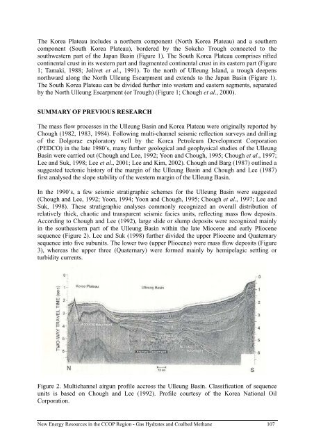
According to Chough and Lee (1992), large slide or slump deposits were recognized mainly<br />
in the southeastern part of the Ulleung Basin within the late Miocene and early Pliocene<br />
sequence (Figure 2). Lee and Suk (1998) further divided the upper Pliocene and Quaternary<br />
sequence into five subunits. The lower two (upper Pliocene) were mass flow deposits (Figure<br />
3), whereas the upper three (Quaternary) were formed mainly by hemipelagic settling or<br />
turbidity currents.<br />
Figure 2. Multichannel airgun profile accross the Ulleung Basin. Classification of sequence<br />
units is based on Chough and Lee (1992). Profile courtesy of the Korea National Oil<br />
Corporation.<br />
New Energy Resources in the <strong>CCOP</strong> Region - Gas Hydrates and Coalbed Methane 107